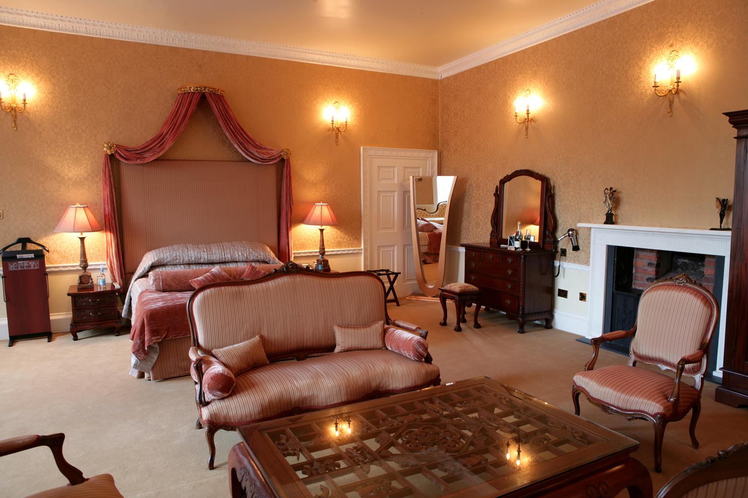


Horspool Retreat
Horspool Retreat offers Self Catering Accommodation for 29 plus guests. The Private Indoor…

Enjoy a pleasant rural stretch of Nottinghamshire's premier river above an historic bridge and weir.
East Bridgford
5.5 miles (8.8kms)
The River Trent is the foremost river in the East Midlands and has always been a key route for trading and transport. It rises in Staffordshire and flows through Stoke, Burton upon Trent, Nottingham and Newark before joining the Ouse to form the Humber. Crossing points, first by ferry or ford and later by bridge, were all important, and communities often grew up close by.
The Trent crossing by East Bridgford and Gunthorpe was a key route into Nottingham, in fact the only bridge over the river between Nottingham and Newark. The location of the first bridge can still be made out near the end of the walk off Trent Lane, with buttresses on both sides of the river and the original Toll House still evident on the far bank. It was built by the Gunthorpe Bridge Company, which raised £7,500 in £10 shares and completed the sturdy iron structure in 1875.
For 50 years it was a private toll bridge and in 1925 the tolls were recorded as 1/- for a horse and carriage, 6d for a horse and wagon, 3d for a horse alone and 1d for ‘people and passengers’. Motorcycles were charged 3d, cars 1/- and lorries 2/6. However, all this came to an end in 1925 when the Nottinghamshire County Council (Gunthorpe Bridge) Act 1925, rather unusually, laid a legal obligation on the local council to buy out the owners, knock down the bridge and replace it with the present stone construction, and to subsequently allow free passage for all users. Indeed, it’s claimed that this was the first ever toll bridge to be replaced by free one.
Near the site of the old bridge is a small marina, which before it was built used to be a wharf where food, building supplies, coal and other goods for East Bridgford were landed. However, what’s likely to be far more distracting is the mighty weir nearby, where the thundering noise of thousands of gallons of plunging water will have been audible long before you actually see it. The weir was built in 1925 in order to maintain the depth of the river between Gunthorpe Lock and Stoke Lock so that large freight ships could continue using it.
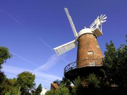
Leaving East Bridgford to head north above the Trent valley, your eyes will be drawn to the former windmill at Mill Farm, now minus its sails. It was known as Kneeton Hills Mill and was a four-storey building that originally had four sails, which was later extended to six. On the southern side of the village was Stokes Mill, another brick-built corn mill that was built in 1828 and which had four double-shuttered patent sails. Both windmills ceased operation in the early part of the 20th century and have been converted into residential properties.
From the centre of East Bridgford, by the crossroads below the church, walk along Kneeton Road out of the village past The Reindeer Inn. Just past Lammas Farm, with the stump of an old brick windmill ahead, turn left on to a wide, semi-surfaced lane signed ‘public bridleway’. Ignore a footpath turning on the right and after 0.25 miles (400m) turn right at a junction for a wide, undulating track between hedges.
Beyond Old Hill, with its communications mast, the track narrows and drops downhill. Before it bends sharply left go across a stile on your right for a path steeply uphill by a line of hawthorn trees. Continue across the level edge of another, then at a junction of routes turn left by a yellow-topped post for a succession of field-edge paths. At the edge of Kneeton go through the metal gate for a lane to reach the Church of St Helen.
Turn left beyond the church for a sunken lane down to the floodplain. Go over the stile and out across Trent Meadows with the river to your right. There is a faint track across the grass, but aim for the stile and gate in the middle of the cross-fence almost 0.5 miles (800m) ahead, then continue through a second field to the far left corner.
Go over a stile ahead/right (not the one uphill to the left) and turn right for a path around the bottom of a small of the wooded slope. Go up a low bank and left, over a stile, for a stepped path up through the trees to an open field. Turn right and walk along the bottom of a succession of large fields for over a mile (1.6km), keeping parallel with the river now some way below on your right.
There are several large wooded gullies you either have to skirt or cross via steps, but follow the waymarked route going straight over at two path junctions. Eventually you go through a gate and down the driveway of a small mobile-home park to the road. To inspect the river and noisy weir at first hand go right and right again on the public path past the marina.
Cross the road by the mobile-home entrance, then go left, through a kissing gate (not the public footpath straight on) for a stepped path along the field-edge above the road. At the end continue back to the centre of East Bridgford.
Field tracks and riverside meadow, may be flooded after heavy rain, steep steps and arable fields, several stiles
Wide river plain backed by steep banks
Good on enclosed tracks, but on lead around livestock in riverside meadows
OS Explorer 260 Nottingham
Kerbside in centre of East Bridgford
None on route (nearest in Bingham)
Read our tips to look after yourself and the environment when following this walk.
Most people associate Nottinghamshire in the East Midlands with the legend of Robin Hood, though the former royal hunting ground of Sherwood Forest has been somewhat tamed since Robin’s outlaw days. Traditionally, the county’s primary industry, alongside agriculture, was coal mining but it is also an oil producing area, and during World War II produced the only oil out of reach of the German U-Boats.
The county is divided between the old coalfields north of the city of Nottingham, the commuter belt of the Wolds to the south, Sherwood Forest and the great country estates known as the ‘Dukeries’. Towns of note are the river port and market town of Newark, which hosts major antiques fairs six times a year, and Southwell, known for the medieval minster with exquisite carvings of Sherwood Forest.
D H Lawrence was a Nottinghamshire man, born in Eastwood, the son of a miner and former schoolteacher. He grew up in poverty, and his book Sons and Lovers reflects the experiences of his early years. Other Nottinghamshire notables include Thomas Cranmer, the first Protestant Archbishop; Jesse Boot, founder of the Boots pharmaceutical company; Henry Ireton, the man who singed Charles I’s death warrant; and Olympic skaters Torvill and Dean.
Discover more than 15,000 professionally rated places to stay, eat and visit from across the UK and Ireland.
Choose a place to stay safe in the knowledge that it has been expertly assessed by trained assessors.
Search by location or the type of place you're visiting to find your next ideal holiday experience.
Read our articles, city guides and recommended things to do for inspiration. We're here to help you explore the UK.