


Ironbridge View Townhouse
Ironbridge View Townhouse is a holiday home, set in the historic Ironbridge Gorge, has stunning…

Ironbridge
4.5 miles (7.2kms)
The little town of Ironbridge is built of mellow brick, its attractive buildings clinging in tiers to the north side of the gorge, overlooking the River Severn. Though it is part of a UNESCO World Heritage Site and a major tourist centre, it has not lost its charm, retaining a maze of steep, narrow streets that mingle with patches of woodland, open to the public and managed by the Severn Gorge Countryside Trust.
The Iron Bridge itself was built by Abraham Darby III, grandson of the man who started it all by smelting iron ore with coke, although the original idea and design were by the largely forgotten Shrewsbury architect Thomas Pritchard. The lack of a bridge across the Severn had become a handicap to the development of industry in the gorge. The bridge was cast in Darby's foundry at Coalbrookdale, cost around £6,000 and contains 378 tons of iron. It carried all kinds of traffic right up to 1934. To get more background, check out the exhibition in the Tollhouse at the south end of the Bridge.
On the climb through Benthall Edge Wood you'll be very aware of the Ironbridge power station; one of its cooling towers looms, seemingly directly overhead, as you reach the start of the climb, and you're only just above them when you reach the top. In fact the towers you see are part of Ironbridge B, built in the 1960s; the older A station is adjacent. The station was designed to be invisible from the historic sites in the gorge and the concrete of the cooling towers has a red pigment added to reflect the colour of the local soil. The single chimney, 673ft (205m) tall, is the tallest structure in Shropshire.
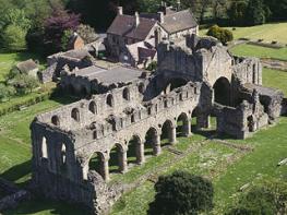
Away from the bustle of the gorge it's almost a different world. After crossing gentle farmland, you come first to St Bartholomew's Church and then to Benthall Hall. The church is an interesting building and worth a visit – just check out that sundial! Next-door Benthall Hall, which was built of stone in the 16th century, presents a stunning face to the world. It's quite something inside as well, and as it's owned by the National Trust you can have a look around (best to check first as it is only open on certain days). There are plaster ceilings and lots of carved oak. Mr and Mrs Benthall still live here so it's a real home, with a warmer feel than many National Trust properties.
Without crossing into Ironbridge, and with your back to the bridge, turn right into Benthall Edge Wood, taking the higher of two tracks and soon passing under a disused railway bridge. When the track comes to an end, with a cooling tower looming ahead, cross a stile on the left and turn sharp left, going uphill to arrive at a major path junction.
Turn right here (signed for Benthall Hall). Stay on the main path, through damp, jungly woodland, nearly always climbing steadily and keeping the same heading. Approaching the top, the path curves round a hollow. Ignore a gate and track on the left and continue, slightly downhill and then roughly level, along a narrower path just inside the edge of the wood.
Leave the wood at a stile and continue along the edge of a field, then bear left and down to a stile just left of Cowslip Cottage. Follow the lengthy access track to a lane. Turn left and follow the lane to a sharp right-hand bend.
Turn left here on a footpath between hedges, sometimes muddy in a couple of spots. Pass a pool and enter a field. Follow the hedge on the right at first then keep going, bearing slightly right to join a vague tractor track. Turn right along field-edges to meet a track by Benthall Hall Farm. Turn right, then left onto a lane to St Bartholomew's Church.
Backtrack down the lane a short way then turn left on an obvious bridleway across parkland, soon passing in front of Benthall Hall. Go through a gate at the far side, after which the clear path continues along two field-edges, meeting a track at the far side. Turn right and at a junction carry straight on down a lane. Approaching another junction, turn left into Workhouse Coppice (owned by the Woodland Trust).
The path soon forks – carry straight on. At the next junction, by a memorial marker, turn right, downhill, then left at a T-junction, and straight on at two subsequent junctions. As you approach the far side of the wood, turn right on a stony track. Before long you'll come to the first of several flights of wooden steps, opposite a bench.
Lots more steps, interspersed with boardwalks, make the descent easier, if rather over-civilised. Just keep going down. At the bottom cross a stile and turn right on the old railway track that you followed at the start. Very soon this goes under the old bridge again and leads out back to the Iron Bridge.
Mostly excellent, muddy in places, lots of steps (down only), 7 stiles
Wooded hills and mixed farmland above Severn Gorge
Will love woods, but keep under control in fields
OS Explorer 242 Telford, Ironbridge & The Wrekin
Bridge Car Park at south end of Iron Bridge
In The Square at Ironbridge
Read our tips to look after yourself and the environment when following this walk.
Perhaps nowhere else in England will you find a county so deeply rural and with so much variety as Shropshire. Choose a clear day, climb to the top of The Wrekin, and look down on that ‘land of lost content’ so wistfully evoked by A E Housman. Peer through your binoculars and trace the course of Britain’s longest river as the Severn sweeps through the county, from the Breidden Hills to Wyre Forest, slicing Shropshire in two. To the north is a patchwork of dairy fields, hedgerows, copses and crops, broken at intervals by rugged sandstone ridges such as Grinshill or Nesscliffe, and dissected by a complex network of canals.
Spilling over the border into neighbouring Cheshire and North Wales is the unique meres and mosses country, with serenely smooth lakes glinting silver, interspersed with russet-tinged expanses of alder-fringed peat bog, where only the cry of the curlew disturbs the silence. South of the Severn lies the Shropshire Hills AONB. It’s only when you walk Wenlock Edge that you fully discover what a magical place it is – glorious woods and unexpectedly steep slopes plunge to innumerable secret valleys, meadows, streams and farmhouses, all tucked away, invisible from the outside world.
Discover more than 15,000 professionally rated places to stay, eat and visit from across the UK and Ireland.
Choose a place to stay safe in the knowledge that it has been expertly assessed by trained assessors.
Search by location or the type of place you're visiting to find your next ideal holiday experience.
Read our articles, city guides and recommended things to do for inspiration. We're here to help you explore the UK.