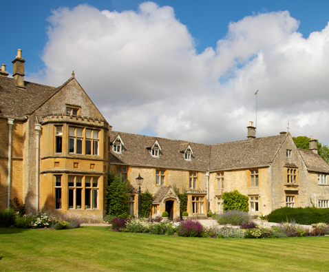
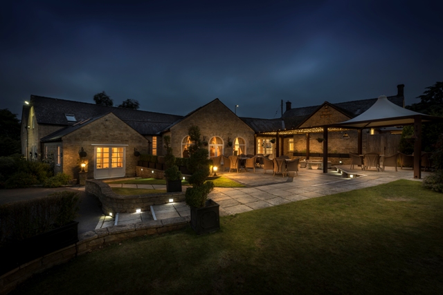

Stow Lodge Hotel
Situated in smart grounds, this family-run hotel has direct access to the market square and…

Following the course of Ryknild Street across the high wold
Condicote
9 miles (14.5kms)
During the first portion of this walk you will be following the unmistakable line of a Roman road, Ryknild Street. This extended northwest from the Fosse Way near Bourton-on-the-Water, crossed Watling Street near Lichfield, and turned northeast to terminate at Templeborough, near Rotherham. The stretch you will be walking along may not have changed much in 2,000 years, even if the ordered landscape that rolls away on either side would not, perhaps, be immediately recognisable to travellers of the era.
It is well known that the Romans built remarkably straight roads throughout Britannia, with a total length of about 10,000 miles (16,000km). Most of these were built during the first 100 years of occupation, which equates to a mile (1.6km) of road every four days. Later roads were not as well built as the earlier ones – road building has always been an expensive business and the Romans sometimes found it expedient not to insist on straight lines.
Roman roads differed from their predecessors in the quality of the road building and the comprehensive coverage of the road network. The basic aim was to link sites with water supplies, which were located a day’s march apart (10–15 miles/16–24km). Alignments were laid out from hilltop to hilltop and then with intermediate points between. Some zig-zagging was permitted, but only for good reasons – hill cuttings, for example, were rarely used, and perhaps only as early military roads. Marshes were not considered an obstacle and roads were built across them by the copious use of brushwood. Fording was preferred to bridges, presumably for reasons of cost and longevity.
The procedure for the construction of the road itself might consist initially of woodland clearance to the tune of a 90ft (27.4m) line, marked by ploughed outer ditches, followed by two more drainage ditches about 30ft (9m) apart that provided the outer limits of the road itself. Material from around about would be dug up and used to build up the roadway. On top of this would go local stone, followed by rubble or gravel, which would then be cambered.
From Condicote village green, with your back to the church, take the road south out of the village. Beyond the houses of Condicote bend left where a footpath leads straight on at a gate and follow the lane to a junction. Go straight ahead onto a track at a sign ‘Unsuitable for Motors’ and follow what is in effect all that remains of Ryknild Street. As you might expect, the route is clear – follow this track for just under 2 miles (3.2km) to the B4068, crossing two roads by further ‘Unsuitable for Motors’ signs.
The views are good from this stretch, with distant glimpses of Cotswold hills, combes and farmland, and either side of the track is a landscape divided by fields and dotted with woodland. The section after the B4068 is a surfaced road, which will bring you to a T-junction. Cross to a gate and stile, and then cross a field to a stile. In the next field, curve right to a stile at the edge of woodland. Cross an estate road to follow a woodland path across a staggered junction to a kissing gate at the edge of a field. Curve left to follow a fence down the field to a gate in the bottom corner.
Turn right along the road. After 100yds (91m) go left and turn immediately right through a gate. Pass through a succession of fields, finally dipping down to a gate and a bridge over a stream. Follow a path up to Upper Slaughter and turn left at the road. At the village triangle turn right and head back towards the river.
Pass the church, then bear left at a Wardens Way sign and follow the bridleway track with the river to your right, passing a house to enter trees. Pass through a gate and cross grassland to gates by Cress Cottage. Walk in woodland for 700yds (640m), eventually descending to the B4068.
Turn left and walk along the road for about 350yds (320m), using the verge where possible. Just before cottages turn right onto a metalled drive rising up between trees. This will take you past Eyford Park. Stay on the drive for 1.5 miles (2.4km), crossing a series of cattle grids, to eventually reach a road.
Turn right for 0.75 miles (1.2km) to a junction where a George VI letterbox is seen on the right, built into the wall of a barn. Turn left, signposted ‘Condicote’, and follow the road to the B4077. Cross over and continue until you come to the road on your left leading back into Condicote. Return to the village green where the walk began.
Track, field, estate road and country lanes; several stiles
Long views across high wolds, estate land, villages
Nice long stretches of track; lead required around livestock
OS Explorer OL45 The Cotswolds
Roadside parking in Condicote village
None on route
Read our tips to look after yourself and the environment when following this walk.
Gloucestershire is home to a variety of landscapes. The Cotswolds, a region of gentle hills, valleys and gem-like villages, roll through the county. To their west is the Severn Plain, watered by Britain’s longest river, and characterised by orchards and farms marked out by hedgerows that blaze with mayflower in the spring, and beyond the Severn are the Forest of Dean and the Wye Valley.
Throughout the county you are never far away from the past. Neolithic burial chambers are widespread, and so too are the remains of Roman villas, many of which retain the fine mosaic work produced by Cirencester workshops. There are several examples of Saxon building, while in the Stroud valleys abandoned mills and canals are the mark left by the Industrial Revolution. Gloucestershire has always been known for its abbeys, but most of them have disappeared or lie in ruins. However, few counties can equal the churches that remain here. These are many and diverse, from the ‘wool’ churches in Chipping Campden and Northleach, to the cathedral at Gloucester, the abbey church at Tewkesbury or remote St Mary’s, standing alone near Dymock.
Discover more than 15,000 professionally rated places to stay, eat and visit from across the UK and Ireland.
Choose a place to stay safe in the knowledge that it has been expertly assessed by trained assessors.
Search by location or the type of place you're visiting to find your next ideal holiday experience.
Read our articles, city guides and recommended things to do for inspiration. We're here to help you explore the UK.