


Memnon Cottage
Situated on Lindisfarne (Holy Island) with a large, light and airy living area and an…

Lindisfarne
5.5 miles (8.8kms)
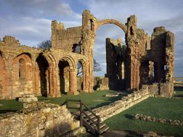
St Aidan travelled to Lindisfarne from Iona in AD 635 at the invitation of King Oswald, to bring Christianity to a heathen land. He founded a monastery on the island, which was little more than a simple wooden chapel ringed by a few crude huts, from which he and his followers took their ministry into the surrounding countryside. When Aidan died at Bamburgh in AD 651, a young lad tending sheep in the nearby hills saw a vision of his soul passing to heaven and was so moved that he journeyed to Melrose Abbey and sought admittance as a monk. Called Cuthbert, he too eventually came to Lindisfarne, first as its prior and later, reluctantly, as its bishop. Well known for his preaching, Cuthbert developed healing powers and attracted people wherever he went. But his vocation increasingly drew him to prayer and meditation and, in his later years, he withdrew, first to the offshore island here, and then to Inner Farne, where he ended his days.
Cuthbert's body was brought back to Lindisfarne for burial and a cult developed around his memory. Eleven years later, when his body was exhumed to enshrine his bones, the remains were discovered completely undecayed 'as if he were just asleep'. It was to commemorate Cuthbert's elevation to sainthood that the famous Lindisfarne Gospels were written, by a monk called Eadfrith, who later also became bishop.
The miracles of St Cuthbert drew increasing numbers of pilgrims and the monastery grew both in wealth and influence. However, it also attracted unwelcome visitors, the Vikings, and in AD 875 the monks were forced to abandon the island, taking with them the relics, gospels and even wood from Aidan's original chapel, in search of a new home, which they eventually found at Durham.
In the 11th century, monks from Durham (by then a Benedictine community) returned to Lindisfarne and refounded the priory, building a church on the site of the chapel where Cuthbert had been buried. About the same time, the parish church was erected and the place became known as Holy Island. At first the monastery prospered, but increasing border hostility at the end of the 13th century ruined the lands upon which it depended. By the Dissolution in 1537, perhaps only a prior and a couple of monks remained here.
The island was first fortified in the 1540s to serve as a landing for raids upon Scotland. It never saw significant action, but remained garrisoned until 1819. In 1901, the publisher Edward Hudson bought the castle and employed Edwin Lutyens to transform it into a worthy residence. Out of an uninspiring and utilitarian bastion, the architect wrought this intriguing medieval pocket mansion, a fascinating example of the inventiveness and harmony that Lutyens brought to his work.
Head back from the car park towards the shore. Just beyond the bend, a signed footpath lead through a gate on the right onto a nature reserve. Go ahead where it splits, making for a lime kiln, half buried in the dunes. Keep on across an open area, crossing more sand hills to find a ruined building. Through a fence gap behind, continue forward to the beach.
Swing right along the strand, which soon gives way to a bare, wave-cut platform, where the rock can be slippery. Rounding Snipe Point there is the surprise of a secluded cove, but again, take care crossing boulders below the low cliffs at the far side. If the tide is in, you will need to abandon the shore for a path above. Beyond Castlehead Rocks, the going improves behind another expanse of beach, divided at low water by the exposed reef of Keel Head. If you have not already done so, leave the foreshore at the far side and continue to a navigation marker on Emmanuel Head.
The route now runs at the edge of the dunes above a rocky apron washed by the sea. Beyond the corner of a fence, cross a stile and carry on ahead towards the distant Lindisfarne Castle. Eventually, join a raised tramway that curves past old lime kilns. After crossing a bridge, climb a grass bank to pass left of the castle.
The way continues along a lane behind the bay towards the village, forking left past upturned boats to the harbour. In the harbour yard, bear right past fishermen's sheds on a gravel path that rises onto The Heugh. Swinging right at the top, walk past a Celtic cross war memorial, designed by Lutyens, and the former coastguard lookout, now refurbished as a watch tower and interpretation centre.
Beyond, a rugged path drops from the exposed whinstone of The Heugh's western snout. At the bottom wind right on a track from the beach up to St Mary's Church. Turn into the graveyard and walk around the northern side of the church. Leave left through a gate past the Lindisfarne Priory Museum.
Follow the street through Market Square and along Crossgate to a junction in the centre of the village. The Lindisfarne Centre is just a short distance to the left along Marygate, while the car park lies some 0.25 miles (400m) along Berwick Road ahead.
Shore and dunes, clambering on rocky shore (avoidable), 1 stile
Dunes and expansive inter-tidal sands
Dogs should remain on leads through village
OS Explorer 340 Holy Island & Bamburgh
Large pay-and-display car park at entrance to village
Signed within village
<p>Check tides; causeway onto island impassable at high water, walk best undertaken at low tide</p>
Read our tips to look after yourself and the environment when following this walk.
If it’s history you’re after, there’s heaps of it in Northumberland. On Hadrian’s Wall you can imagine scarlet-cloaked Roman legionaries keeping watch for painted Pictish warriors while cursing the English weather and dreaming of home. Desolate battlefield sites and hulking fortresses such as Alnwick, Dunstanburgh, Bamburgh and Warkworth are reminders that this, until not so very long ago, was a contested border region. The ruins of Lindisfarne bear witness to the region’s early Christian history.
Northumberland also has some of Britain’s best beaches. On summer days, and even in winter, you’ll see surfers and other brave souls making the most of the coast. Inland, there are some great walks and bike rides in the dales of the Cheviot Hills and the Simonsides – just hilly enough to be interesting, without being brutally steep. There's dramatic scenery in the High Pennines, where waterfalls plunge into deep valleys, and there are swathes of heather-scented moorland. Northumberland National Park covers over 400 square miles of moorland and valleys with clear streams and pretty, stone-built villages. It’s just the place for wildlife watching too. You’ll find flocks of puffins, guillemots and other seabirds around the Farne Islands, and seals and dolphins offshore.
Discover more than 15,000 professionally rated places to stay, eat and visit from across the UK and Ireland.
Choose a place to stay safe in the knowledge that it has been expertly assessed by trained assessors.
Search by location or the type of place you're visiting to find your next ideal holiday experience.
Read our articles, city guides and recommended things to do for inspiration. We're here to help you explore the UK.