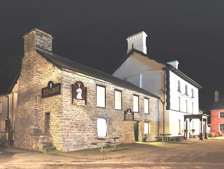


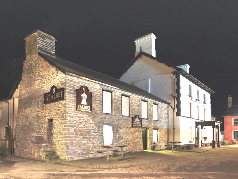
Y Talbot
Located in the heart of this quiet town, Y Talbot has been appointed to provide a range of very…

Following ancient monastic trails round the Teifi Pools
Teifi Pools
6.25 miles (10kms)
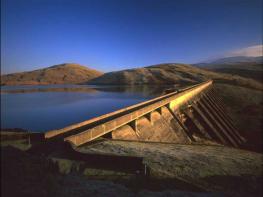
The Teifi Pools is the collective name for a group of small lakes (some of which have been enlarged by dams) high up in the hills to the east of Pontrhydfendigaid. The lakes, which are popular with fishermen and possess a stark, austere beauty, lie some 1,500ft (450m) above sea level in an area of wild, open moorland often referred to as Wales’ ‘green desert’. The largest of the lakes, Llyn Teifi, is traditionally considered to be the source of the Afon Teifi, at 76 miles (122km), the longest Welsh river wholly within Wales.
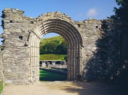
Driving up the Teifi Valley from Pontrhydfendigaid (known colloquially as ‘Bont’), you will pass the former Cistercian abbey of Strata Florida. Founded in 1164 under the patronage of the Lord Rhys (1132–1164), a native Welsh prince of Deheubarth, the abbey developed into one of the great buildings of medieval Wales. Under Rhys and his successors, it also acted as a focus for resistance to Anglo-Norman occupation.
The abbey’s significance derived from the loss of St Davids to the Normans in the 12th century. As a result, the Welsh princes of Deheubarth (a former kingdom based in the southwest of Wales) transferred their patronage to the new abbey at Strata Florida, transforming it into the cultural and spiritual centre of the Welsh fight for independence. The abbey grounds claim to be the final resting place for no fewer than 11 Welsh princes, as well as the greatest of Welsh poets, Dafydd ap Gwilym (active in the 14th century). It was also in Strata Florida that Brut y Tywysogion (Chronicle of the Princes) was written, which is one of the most important primary sources for medieval Welsh history.
Unfortunately, this once splendid abbey is now in an extremely ruinous state, and compares unfavourably with Wales’ best-preserved monastic remains at Tintern. It is likely that Strata Florida paid the price for staunchly supporting Wales’ native princes. The abbey was badly damaged during the final years of Welsh independence at the end of the 13th century and again during the Glyndwr Rising (1400–15), when an English garrison was quartered there.
Between Tyncwm farm and Llyn Egnant, the walk route follows an ancient trackway known as the Monks’ Trod. This was developed by Cistercian monks to connect Strata Florida with Abbeycwmhir in Powys, and rises above Tyncwm along the tumbling mountain stream of Nant Egnant. The path then runs along the shores of Llyn Egnant (now a road), where the monks farmed eels and trout for food.
From the lay-by, walk back down the lane for a short distance to reach a bridleway sign by a bench. Turn right and follow an obvious path in the direction of Nant Egnant, a tumbling mountain stream that is crossed by a footbridge. Climb a steep bank ahead and turn left on to the track from Tyncwm farm.
Further up this beautiful rocky valley, Nant Egnant is crossed once again, this time by a ford. Continue through a gate, following the obvious path ever higher up the mountain. Not far past a cairn, the path bears left round a corner, and Llyn Egnant appears suddenly before you.
Pass through a gate and continue across a short boggy section towards the lake. Join a metalled track alongside the dam and follow this along the left-hand shore of the lake. Beyond Llyn Egnant, the track climbs to reach a T-junction with a narrow, unfenced lane.
Turn left and follow this winding, undulating lane for just over 0.5 miles (800m). Take the second vehicle track on the left, which crosses more open moorland towards the largest of the lakes, Llyn Teifi. Continue along the right-hand edge of the lake to a dam.
Where progress is blocked by a rusty iron gate, join a narrow path to the right of a fence and track. At the end of the fence, the path bears slightly right, winding its way down a valley to a stile. Cross over and ford a stream (the infant Afon Teifi). Bear right and follow the river downstream.
The valley opens out near a stone cairn. Continue downstream, now with a fence between the path and the river. Where the stream comes back under the fence, bear left to pick up a path higher up the valley slope. Go through a wooden gate and follow a clear path curving left round the hill towards Frongoch farm.
Bear right in front of the abandoned farmhouse and follow the farm track down to the next house along, Troed-y-rhiw. With the house on your immediate right, bear left through a gateway and continue along the bottom edge of a field, with the hedge to your right.
At the end of the field, the path joins a narrow ledge as it curves left across a steep, open slope. Descend obliquely down the hill to rejoin the lane from Strata Florida. Keep ahead up the valley to return to the lay-by.
Moorland bridleways and surfaced tracks, boggy in places (2 stiles)
Mountain lakes, open moorland, upland river valleys
Mostly open country, though dogs will need to be kept on a lead near sheep
OS Explorer 187 Llandovery and OS Explorer 213 Aberystwyth & Cwm Rheidol
Small lay-by 1.7 miles (2.75km) east of Strata Florida abbey, just west of Tyncwm farm
None on route
Read our tips to look after yourself and the environment when following this walk.
The name ‘Ceredigion’ takes a bit of explanation. The town of Cardigan gives its name to the surrounding bay, but the county now uses the Welsh word for Cardiganshire – Ceredigion, pronounced with a ‘dig’. Cardigan Bay itself is a large inlet of the Irish Sea and stretches from Bardsey Island to Strumble Head. With many beaches and a unique marine life, it’s the place to come to spot bottlenose dolphins, porpoises and Atlantic grey seals. The area is a Special Area of Conservation (SAC), designated under European law to protect its species and habitats. The Ceredigion coastal path is also a major attraction.
Much of the surrounding land is fertile farmland, dotted with towns and seaside resorts such as Fishguard, New Quay, Aberaeron, Aberystwyth, Borth, Aberdyfi, Barmouth and Porthmadog. It’s also a section of coast that major rivers flow into, including the Afon Glaslyn, Teifi, Rheidol, Dyfi, Aeron, Dysynni and Mawddach. Historically, the area supported a strong maritime industry. Cardigan was a major hub, once having more than 300 ships registered in its port, seven times as many as Cardiff. Due to being something of a backwater, in many ways this area remains charmingly unspoilt. The nearby heather-clad Preseli Hills are an additional delight.
Discover more than 15,000 professionally rated places to stay, eat and visit from across the UK and Ireland.
Choose a place to stay safe in the knowledge that it has been expertly assessed by trained assessors.
Search by location or the type of place you're visiting to find your next ideal holiday experience.
Read our articles, city guides and recommended things to do for inspiration. We're here to help you explore the UK.