Additional information
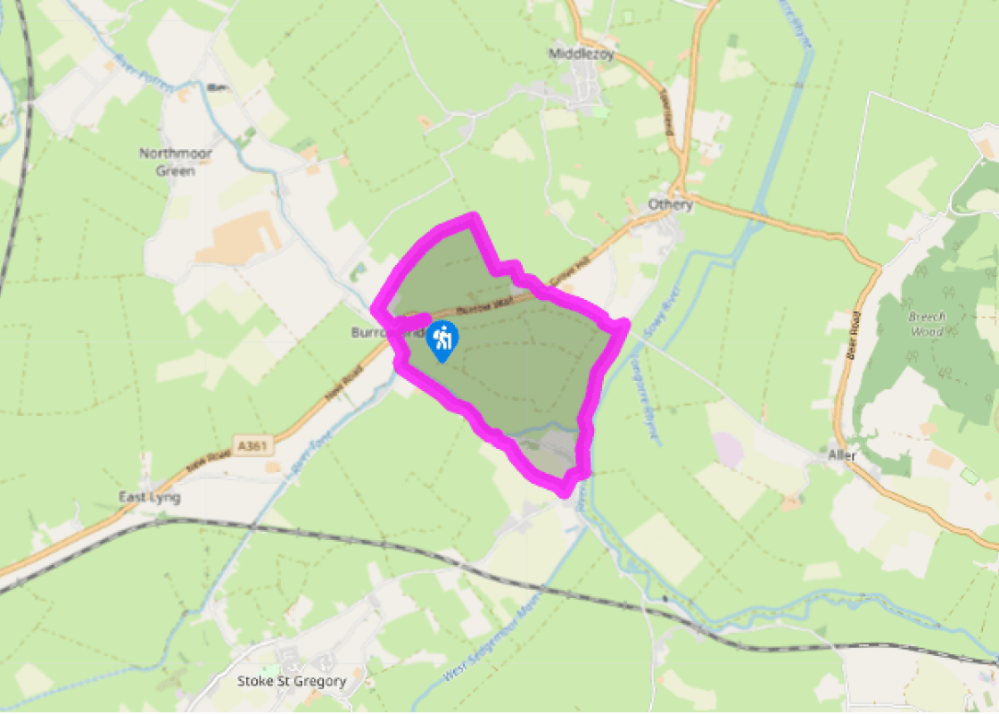
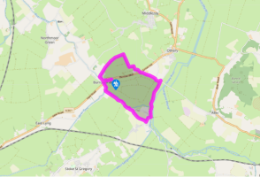
Terrain
- Tracks, paths, unfrequented field-edges
Landscape
- Flat pasture with ditches and one surprising, small hill
Dog friendliness
- Good on drove tracks where dogs are separated from livestock by deep ditches
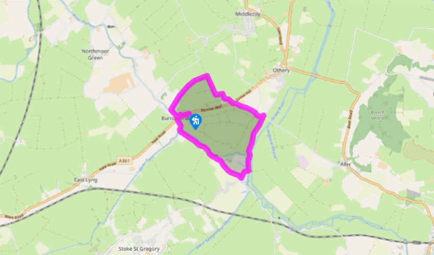
Parking
- National Trust car park (free) at Burrow Mump
Toilets en route
- None on route
About the walk
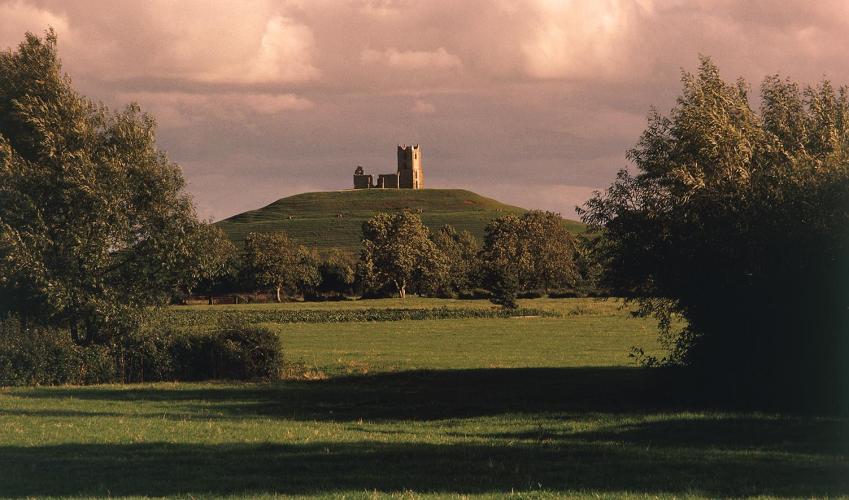
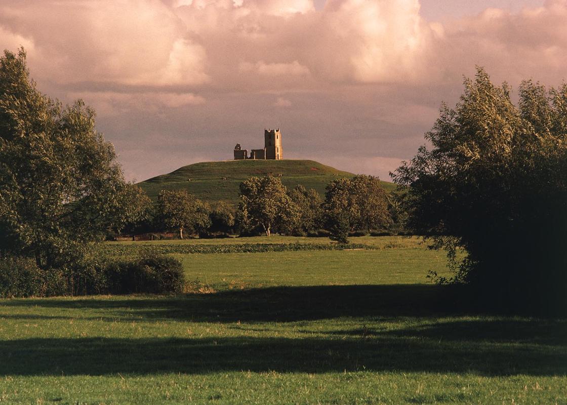
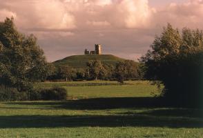
After the last ice age, around 10–18,000 years ago, this ground was under the sea; in one sense it still is, as the high tide in the Bristol Channel rises up to 20ft (6m) above the fields and ditches. If the sea ever does get back in, it will lap against Glastonbury Tor and make Bridgwater and... Burnham reminiscent (albeit in just one sense) of Venice – they will have canals instead of streets. The draining of this ground started in Roman times, but gathered pace in the early Middle Ages. The three centuries following the Norman conquest (until the Black Death) brought increasing prosperity and security, shown by, among other things, the windmills that sprung up along the Polden Hills. The growing population required more land to be drained for the plough and the cow. Summer pasture The water-meadows around Barrow Mump were first drained by the monks of Glastonbury Abbey in about 1255. They raised walls to keep out the pervasive waters of the River Parrett, to form fertile water-meadows. In winter these would be allowed to flood, their soils enriched by silt from the river. In summer the drained grasslands formed highly fertile grazing land for their cattle, with convenient and effective wet fencing and plenty of fresh drinking water. This agricultural process may give us the origin of 'Sumor Saete' or Somerset, the 'land of summer'. Drainage was continued through the ages: the King's Sedgemoor Drain, with its complex arrangement of sluices and pumps, was constructed in the 19th century; and managed drainage came to the Huntspill River area during World War Two. Wind pumps were replaced by steam-powered engines and then by the diesel one that may be heard thumping in the distance at the start of the walk. Our route is around the drove tracks and the river barriers, with a final ascent of Burrow Mump for an overall view. In the days when the surrounding ground was swamp, Burrow Mump was occupied by the local Celtic people against the Romans. In the Anglo-Saxon era, it was a strongpoint of King Alfred's; he fortified it against Danish raiders coming up the River Parrett. Later it held a Norman castle. Once the surroundings were drained its tactical value decreased, and the present Chapel of St Michael was built by the monks of Athelney Abbey. Even so it remained an obvious strongpoint, and the chapel was held by the Royalists in 1645 after their crushing defeat by Cromwell's New Model Army at the Battle of Langport. It was partially destroyed on that occasion, restored in the 18th century, and has fallen back down again since then. The summit, though only raised 100ft (30m) above the sea-level surroundings, commands a wide and interesting view. Half a dozen parish churches can be seen in various directions. The closest of these, looking due north from the Mump, is St Mary's in Westonzoyland, with its square tower. Here captured rebels were imprisoned by government troops after their defeat at the Battle of Sedgemoor in 1685. Closer at hand, the distinctive pattern of droves (tracks) and walls (river barriers, originally 12ft (4m) high and 30ft (9m) wide) can be seen around the water-meadows.
Read more
Somerset
Somerset remains rural and unspoiled, and ever popular areas to visit are the limestone and red sandstone Mendip Hills rising to over 1,000 feet, and by complete contrast, to the south and southwest, the flat landscape of the Somerset Levels. Another popular spot, the Quantocks, once the haunt of poets Coleridge and Wordsworth, are noted for their gentle slopes, heather-covered moorland expanses and red deer.