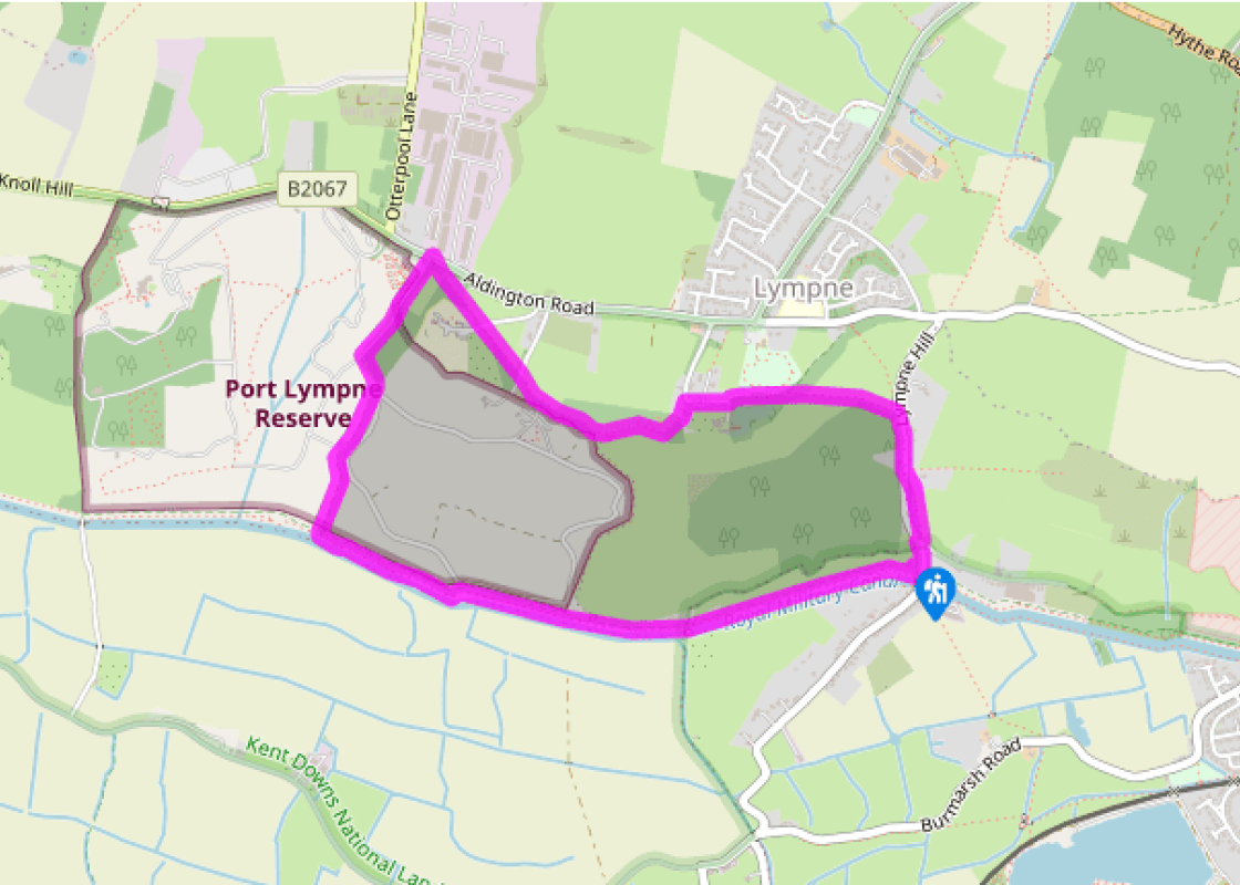
By the Royal Military Canal at Hythe

Exotic animals and ancient buildings on a walk near the Royal Military Canal.

NEAREST LOCATION

West Hythe

RECOMMENDED BY
DISTANCE

3 miles (4.8kms)

ASCENT
328ft (100m)
TIME
2hrs
GRADIENT
DIFFICULTY
Hard
STARTING POINT
TR124342

About the walk

This walk passes through part of the wildlife park at Port Lympne – where you’ll almost certainly meet a few of its inhabitants – and some very English countryside with a highly unusual geology and quite a history, too. The first section follows the Royal Military Canal west of Hythe, scarcely wavering above sea level. You then ascend a very sharp incline to the top of an inland cliff, giving grandstand views over Romney Marsh to the open sea. The manorial village of Lympne is a medieval time warp, and there are glimpses of even older buildings on the jumbled slopes below.

The Royal Military Canal

This grand project formed part of the defences against a possible Napoleonic invasion in the early 19th century. The low-lying Romney Marsh seemed an obvious place for troops to land, so the 28-mile (45km) canal was laboriously constructed by hand between 1804 and 1809. The earth dug out of the trench was piled up alongside as a rampart from which troops could fire at invading forces, but the steep terrain immediately behind the canal created an even more formidable natural barrier. Now fully restored, it has taken on a new lease of life as a leisure and wildlife site. It also controls the drainage of Romney Marsh.

Port Lympne Reserve

The late John Aspinall’s animal park occupies a 600-acre (243ha) site in the grounds of an elegant 1920s mansion. It promises a great family day out, and claims a serious conservation role in protecting and breeding endangered animals, where possible returning them to the wild. The philosophy behind its ‘African Experience’ is to allow species to roam freely together as they would in their native habitats. Prize exhibits include large herds of black rhino and Przewalski horses.

Walk directions

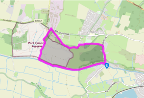
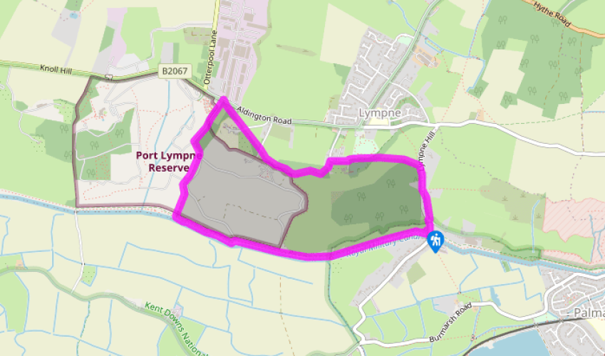
From the car park at West Hythe, take the towpath westwards for just over a mile (1.6km). On the first section of the walk, two paths run parallel along the canal: one a bridleway, the other a raised bank for walkers (the latter is dryer and smoother, with better views of the waterfront). Pass a footbridge on your left after about 800yds (732m), and shortly afterwards, look out for the crumbling masonry of Stutfall Castle (an old Roman fort) to your right. Ignore a footpath to the right at this point and carry on along the towpath.

After a mile (1.6km) or so, look out for strange creatures in the grounds of Port Lympne Reserve, right. Watch carefully for a footpath signed to your right, over a wooden footbridge. Start a steady climb uphill. The track weaves a bit but is easy to follow and strongly fenced to either side, especially at the elephant enclosure towards the top. At one point there is a crossing point with gates where Port Lympne staff can take vehicles or animals from one side to the other. The path now gets steeper.

Eventually the path levels and you reach a road. Just before this, take the footpath signed to your right and walk through woodland past post-and-wire fencing. Cross the drive to Lympne Place and carry on over another lane. Continue ahead, ignoring the steep path adjoining on your right.

The path now skirts the edge of more woods. Follow it bearing left through offset rails towards the houses of Lympne. Go out to the road and turn right, passing Lympne Castle. Walk through St Stephen’s churchyard.

Take the gate at the far side, turning right on the lane and right again over a footpath stile in a few paces. Head downhill on a steep, uneven path, crossing another stile at the edge of the trees. Now go half left down sloping pasture to the road below.

Cross another stile at the field-edge, turn right on the road (Lympne Hill) and walk downhill. At a house called Long Barrow on your left, take the second waymarked path through a gate and walk past a 1930s art deco-style house. Follow the path down a long, narrow field, with a brook on your left, to a stile at the bottom. Emerge on the road at a junction by a garage, JAC Motor Enterprises.

Bear right down the main road for a few paces until you reach the car park just before the bridge.

Additional information

Canal tow path, fields and wooded hillsides; village streets; steep gradients; several stiles

Scenic waterfront and wooded cliff, with some unexpected wildlife

Should be kept under control in orchards, near stock or on roads

OS Explorer Dover, Folkestone & Hythe

West Hythe car park (by the canal bridge)

None on route; nearest in Hythe, near The Green on the corner of Chapel Street, or at the library/museum

Been on this walk?

Send us photos or a comment about this route.

Know a good walk?

Share your route with us.

WALKING IN SAFETY

Read our tips to look after yourself and the environment when following this walk.

Find out more

Why choose Rated Trips?

Your trusted guide to rated places across the UK
icon example
The best coverage

Discover more than 15,000 professionally rated places to stay, eat and visit from across the UK and Ireland.

icon example
Quality assured

Choose a place to stay safe in the knowledge that it has been expertly assessed by trained assessors.

icon example
Plan your next trip

Search by location or the type of place you're visiting to find your next ideal holiday experience.

icon example
Travel inspiration

Read our articles, city guides and recommended things to do for inspiration. We're here to help you explore the UK.