
Filey Brigg Touring Caravan & Country Park
A municipal park overlooking Filey Brigg with splendid views along the coast and set in a…

An easy walk over a dramatic headland and the beach that shelters behind it.
Filey
2.25 miles (3.6kms)
You don’t need to be an expert geologist to see the contrast between the ragged headland of Filey Brigg and Bempton Cliff across the bay. Filey Brigg’s crumbling red cliffs look like badlands from the Wild West, while Bempton Cliff is vertical and greyish-white. Bempton Cliff is chalk, in fact the northernmost chalk cliff in Britain. Locally, the upper part of the promontory – the part explored on this walk – is known as Carr Naze, with Filey Brigg referring specifically to the rocky tail that extendings out to sea; its furthest point is called Brigg End.
The cliffs of Carr Naze, especially on the side facing the bay, are mostly composed of glacial deposits or till, which – as you can readily see – are soft and easily eroded. Underlying these, and showing more clearly on the seaward side, are a succession of limestone and sandstone strata. At low tide these rocks can be seen to form an extensive platform on the bay side and towards Brigg End. When the tide is low it is possible to cross the platform linking the end of Carr Naze to the sandy beach, but the rocks are slippery and the paths on the flank of Carr Naze are steep and eroded. Try it if you like, but at your own risk.
Crumbling they may be, but these cliffs have sheltered Filey Bay for millennia. It is likely that the area was occupied in pre-Roman times, but the first clear archaeological evidence is a Roman signal station (which has good line of sight to the one at Scarborough) on Carr Naze. This is dated to the fourth century, late in the Roman occupation. Many people believe that a mostly submerged structure, called the Spittal Rocks, was actually a Roman pier, probably part of a harbour.
While there’s little direct evidence of human habitation in Filey after the Romans left, it’s highly likely that a small fishing village existed here. More definitely, parts of St Oswald’s Church date back to the 12th century. Filey grew rapidly in the 19th century, with planned development centred on the elegant Crescent. The arrival of the railway in 1846 cemented its future as a resort. In 1947 a Butlin’s Holiday Camp, opened – complete with its own railway halt – to the south of the town. At its peak in the 1960s it could accommodate more than 10,000 visitors, but it closed in 1983. After years of dereliction the site has been partly redeveloped for holiday homes.
Near the start of the walk is a tall marker stone, denoting the start/finish point of both the Wolds Way and the Cleveland Way. The Cleveland Way is a 109 mile (175km) route which runs up the coast past Whitby to turn inland at Saltburn-by-the-Sea. It then runs down the northern and western fringes of the North York Moors to finish at Helmsley.
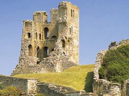
Go through the gate beside the interpretive signs in the corner of the car park and walk towards a tall pointed marker stone showing the start/finish of the Wolds Way and the Cleveland Way. Continue straight ahead to the edge of cliffs overlooking the North Sea. A small promontory here has good views north to Scarborough, with its castle, and the coast beyond.
Turn right along the cliff-edge path, passing the site of the Roman signal station. Beyond this the promontory narrows so much that there’s only room for a single wide path. Reach a fork in the path. The branch on the right looks as if it will take you down to the beach, but it’s quite eroded and awkward at the bottom.
Instead take the main, left, fork until this too becomes a dead end at a stern warning sign. They’re not joking either: the path beyond this point is no longer maintained and runs out onto a very narrow and obviously crumbling ridge. So turn around and retrace, this time sticking to the main path, then follow the edge of a mown grassy area just below the car park, a few paces back from the edge of the cliffs above the beach.
Where a steep valley cuts into the cliff edge, a marker post on the corner indicates the start of some steep steps. Follow these down to a tarmac lane and turn left down its steep lower end to Filey Sailing Club, then right down the ramp onto the beach. You might want to walk along left to look at the badlands cliffs from below, but the main route continues right to another ramp/slipway at Coble Landing.
Go up the ramp and along past cafes, amusement arcades and souvenir shops to the road. Turn right up Church Ravine, then right again up steps near a telephone box. Keep right where the path splits (though it doesn’t really matter, as all the paths come out to the same open grassy area).
Follow the right-hand edge of the grassy space, above the cliffs, until it turns a corner. Go left above the little valley that you descended into earlier, to meet a road near the Country Park Stores and Café. Turn right along this road to return to the car park.
Clifftop paths, beach and pavement, some steps
Windswept headland, sheltered bay and country park
No livestock on the route but plenty of cliff edges, so take care
OS Explorer 301 Scarborough, Bridlington & Flamborough Head
Filey Country Park North (pay-and-display); park in grassed area beyond the cafe
At the bottom of Church Ravine and at the country park
Read our tips to look after yourself and the environment when following this walk.
Discover more than 15,000 professionally rated places to stay, eat and visit from across the UK and Ireland.
Choose a place to stay safe in the knowledge that it has been expertly assessed by trained assessors.
Search by location or the type of place you're visiting to find your next ideal holiday experience.
Read our articles, city guides and recommended things to do for inspiration. We're here to help you explore the UK.