


Pomeroy Caravan Park
Pomeroy Caravan Park is a small, family-run dairy farm, with a shop selling its own artisan ice…

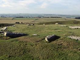
Ride the Dragons Back (the limestone ridge of Chrome Hill) if you dare. Spectacular views await those who do.
Axe Edge
6.3 miles (10.3kms)
At the far end of the Dove Valley stands Axe Edge. This is the Pennine watershed and near to here five rivers – the Goyt, the Dane, the Dove, the Wye and the Manifold – go their separate ways towards the Irish and North Seas. You’re 1,660ft (506m) above sea level on one of the wildest gritstone moors of the Dark Peak, but when you look east you’re looking across to the White Peak valley of the Dove. It’s a fascinating view with several rocky hills vying for attention. One angular hill stands out from all the rest that’s Chrome Hill, and it’s the highpoint of the day. It’s tough and rugged going from that direction though, so this walk starts more gently from Earl Sterndale to the southeast. There’s a fabulous view over Parkhouse and Chrome Hills from Hitter Hill, but the direct descent is steep, so a less steep way snakes diagonally down to the valley, then below Parkhouse Hill.
Chrome Hill and its neighbours are the remains of coral reefs formed over 320 million years ago, when Derbyshire lay under a warm tropical sea near the equator. Arches and caves, spires and fissures have been carved out of the coral and you can see why it’s sometimes known as the Dragon’s Back. There’s a steep downhill section to do before the climb, then the footpath seems to take a timid line along the west side. Just as you think you’ve missed the summit path, the one you’re on turns left and climbs for the sky. The path doesn’t always keep to the crest, but avoids mild scrambles by plotting a devious course round the top rocks. Experienced walkers with a head for heights may well prefer to ‘ride the dragon’s back’. From the top, Parkhouse Hill captures your attention. It’s not unlike Chrome Hill, but the start and ridgeline is very tough with some awkward discontinuous sections where the ridge drops down a crag. If you’ve found Chrome Hill easy then give it a go. This route descends to the little road at its foot, and takes a good look from below before following a path across the pastures to its west.
From the green in the centre of the village, skirt to the right of a pub (currently closed), then bend left around it, following footpath waymarkers towards Longnor as the path divides. Go through a gate with a yellow-topped post and rise gently up through fields. Cross a rough stile on to the higher ground of Hitter Hill. The summit is unmarked but in line with the ridge from Parkhouse and Chrome to the north.
The descent to the far corner of access land is very steep, so return to the previous stile then head right along the field edge-top, to a stile in the corner. Continue briefly along the top edge in the next field, then fork right at a waymarker to Longnor. This narrow path descends diagonally across fields on a steep hillside to a tarmac track by a farm.
Fork right along this track. At Glutton Bridge, turn left along a road, then next right up a narrow lane. This leads underneath the western flanks of Parkhouse Hill.
As the road bends right to cross the col between Parkhouse and Chrome Hills, fork left on to a byway, which initially runs along Stannery Farm’s driveway. Follow signs to Hollinsclough, ignore a left fork, then bypass a ford on a footbridge. At a T-junction of farm tracks go left. At a surfaced lane, go right then right again in Hollinsclough.
At the edge of the village, fork right through a gate on to a footpath. Bend right and down to cross an old stone footbridge. Go through an old metal gate and bend left up a bridleway track. At the top, turn left on to a farm track. Follow this all the way to a junction with a tarmac lane near Booth Farm and turn right.
At a bend left, fork right over a stile on a concession path which follows a farm track to a pair of gates. Cross a stile by the left gate then follow waymarker posts gently left to a wall stile. Bend slightly left at a gate, reaching a track by a waymarked junction. Continue towards Chrome Hill with the top wall on your left.
Go through three gates, then follow waymarkers near a field edge and steeply downhill. Cross a gate on your left; at the next gate, climb left to the ridge. Turn right along the ridge to follow the path over Chrome Hill, bending left at the end to the lane beneath Parkhouse Hill.
Head southwards down the lane, forking left on to a footpath that veers gently away from the road under the western slopes of Parkhouse Hill.
Cross the road and back into fields, heading diagonally left across rough trackless ground. Head directly across the next field, then diagonally right across a third, passing a jutting-out wall corner on your left. Pass through four gates in quick succession near a house to return to the green.
Mostly reasonable paths and tracks, but some are rugged, steep ridgeline, can be muddy or slippery after rain.
Gritstone moors and cloughs with limestone hills
Farmland; dogs should be kept under close control
OS Explorer OL24 Peak District – White Peak Area
On roadside in Earl Sterndale (limited space)
None on route
Read our tips to look after yourself and the environment when following this walk.
The natural features of this central English county range from the modest heights of the Peak District National Park, where Kinder Scout stands at 2,088 ft (636 m), to the depths of its remarkable underground caverns, floodlit to reveal exquisite Blue John stone. Walkers and cyclists will enjoy the High Peak Trail which extends from the Derwent Valley to the limestone plateau near Buxton, and for many, the spectacular scenery is what draws them to the area.
The county is well endowed with stately homes – most notably Chatsworth, the palatial home of the Duke and Duchess of Devonshire, with its outstanding collections of paintings, statuary and art. Other gems include the well preserved medieval Haddon Hall, the Elizabethan Hardwick Hall, and Kedleston Hall, whose entrance front has been described as the grandest Palladian façade in Britain.
The spa town of Matlock is the county’s administrative centre and other major towns of interest include Derby and the old coal mining town of Chesterfield, with its crooked spire. Around the villages of Derbyshire, look out for the ancient tradition of well dressing, the decorating of springs and wells – the precious sources of life-sustaining water – with pictures formed from flowers.
Discover more than 15,000 professionally rated places to stay, eat and visit from across the UK and Ireland.
Choose a place to stay safe in the knowledge that it has been expertly assessed by trained assessors.
Search by location or the type of place you're visiting to find your next ideal holiday experience.
Read our articles, city guides and recommended things to do for inspiration. We're here to help you explore the UK.