Sandman Signature London Gatwick Hotel
A short drive from the UK’s second-busiest airport, Sandman Signature London Gatwick Hotel is…

This fine park has many good paths, lakes and varied landscapes as well as attractions such as the Nature Centre.
Tilgate Park
3.75 miles (6kms)
Originally within the Worth Forest held by William de Warenne, Earl of Surrey, Tilgate was separated out from the forest, and by the 16th century a mansion apparently existed near the main lake.
In the 1860s John Nix bought the estate and set about making his mark. He built a large Tudor-style stone mansion of many gables and chimneystacks, on the site now occupied by the empty pub, with fine views over the lakes and the park. He and his successors planted the pinetum, and the kitchen garden where their vegetables, fruit and house flowers were grown is now the Walled Garden. In the 1930s the estate was broken up. Sir Malcolm Campbell bought the lakes for developing his attempts at the world speed record (his Bluebird K4 set the record on Coniston Water in 1939). There is a commemorative plaque by the lake.
In 1964 Crawley Urban District Council bought the estate and turned it into today’s park, a much used and much loved ‘green lung’ for the town. In the designation of Crawley under the 1949 New Town Act, 200 acres (81ha) of the Tilgate estate was zoned as public open space, although it was not purchased until 15 years later.
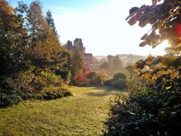
Unfortunately Nix’s mansion was in too poor a state to retain and was demolished, but the stable block survives, converted to flats. The whole park now is thriving, with a popular Walled Garden and Nature Centre, as well as a Go Ape treetop trail for children. The great gales of 1987 severely damaged the Victorian pinetum – a collection of specimen conifer trees – but this has been restored.
Tilgate Lake, the largest of the lakes, underwent a massive engineering project, completed 2011, as part of Crawley’s flood defences. The entire dam was raised and a new spillway was constructed. Some 6,000 lorry loads of clay and other material were brought in for the purpose. Tracks now follow three sides of the lake; near the southeast corner, look for a reedbed, which was created as part of the scheme and which attracts a variety of birds.
From the car park vehicular exit cross the road towards the children’s play area. Go under the Go Ape treetop trail, with its ropeways, and at crosspaths bear left, then right just before an emergency vehicle access area to descend parallel to the road. Head towards the house, then just after the Tilgate Park sign (facing the other way) turn right at the first road junction. Follow this road and cross a bridge past a car park and over a stream, then go right alongside the stream.
Just below the dam bear left onto a metalled track and follow this up and along the side of Tilgate Lake. Towards the end, look out for the information board about the reed bed on the left. Continue past the end of the lake.
Cross a footbridge and then go along the dam of the Silt Lake. At the end continue on the second path from the left amid pines. The path winds within the Pinetum.
Reach a timber footbridge: do not cross it but continue ahead on a broad grassy path (avoiding a minor left fork) amid more open specimen conifer trees. Ahead is the roar of the M23. Reaching the track near the motorway fence bear right and follow the track amid woods. Descend to the valley bottom just as the main track starts to rise.
Cross the stream and just as the main track starts to rise, bear right to leave it. The track winds along in woods beside Titmus Lake. At the end, go right along the dam path, then go right and left to continue ahead uphill with glimpses of alpacas and other animals through the hedge on your right.
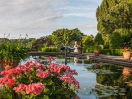
Emerge on a park road and go forward following signs for the Walled Garden, which you soon reach. (You can also follow signs for the Heather Garden and Peace Garden.) After visiting the garden, turn right out of the entrance, along the wall, and then at the first wall corner fork left on a tarmacked path. This immediately curves to the right round a picnic area, then reaches a fork, where you bear left.
At the next junction, go forward, signposted Tilgate Forest Walk, and follow the path to the lake shore. Turn left along the lakeside until the play area comes into view up on the left, and take a path up to it and the main car park.
Footpaths and tracks
Parkland, a golf course, woods including a Victorian pinetum and lakes
Dog friendly
OS Explorer 134 Crawley & Horsham
Tilgate Park Car Park, pay at entry barrier
At the car park and in the Walled Garden
Read our tips to look after yourself and the environment when following this walk.
Discover more than 15,000 professionally rated places to stay, eat and visit from across the UK and Ireland.
Choose a place to stay safe in the knowledge that it has been expertly assessed by trained assessors.
Search by location or the type of place you're visiting to find your next ideal holiday experience.
Read our articles, city guides and recommended things to do for inspiration. We're here to help you explore the UK.