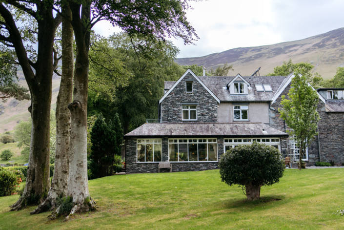


Alban Rise
Alban Rise is a spacious modern three-bedroom property set over two floors with rooftop views of…

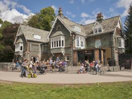
Keswick
15 miles (24.1kms)
Keswick may be the busiest town in Lakeland, but this walk soon leaves the bustle behind and passes into some of the loneliest territory in the district. This passage through the Northern Fells culminates in the ascent of High Pike, at 658 metres (2159ft) the highest point of the Cumbria Way and the one true summit on the route. It is also the most northerly fell over 2,000ft (610m) in the Lake District. From its flat top the view towards Carlisle and the Pennines is panoramic and, very helpfully, it boasts a seat! In good weather this is not to be missed, but it is worth knowing that there is an alternative route at Skiddaw House.
Keswick has ancient roots. It was granted a market charter in the 13th century and in the 16th century became a trading centre for the wool produced in Borrowdale. In 1565 Goldscope copper mine was opened in the Newlands valley and 50 German miners were brought over for their expertise (Goldscope is a corruption of the German name for the mine, ‘God’s gift’). Within two years of the mine opening, Keswick became a thriving industrial town and within the next 150 years huge tracts of woodland were felled to provide charcoal for the furnaces. In the I8th century, the romantic age of tourism began and Keswick became a popular resort. Today, climbers, walkers and tourists rub shoulders in its narrow streets.
Set within a vast expanse of open moorland and protected by conifers, Skiddaw House was originally built for use by shepherds. It has now been renovated and offers simple accommodation if you’d like to split this quite lengthy stage; accommodation is dormitory style and you prepare your own meals.
Follow Station Street and continue ahead into Station Road, crossing the River Greta and passing Fitz Park. Turn sharp right onto Brundholme Road, which loops round left, passing under a railway bridge. Join a path beside the road and continue, crossing a side-road. After 500yds (455m), turn right up a rough track, Spooneygreen Lane.
This bridges the Keswick bypass then climbs steadily around the flanks of Latrigg. After a mile (1.6km), meet a lane and turn right.
Go through a gate or over a stile and turn left. After two gates fork right, soon descending to Whit Beck. The path now climbs gently around Lonscale Fell, giving good views ahead and to the south, before curving left along the narrow valley of Glenderaterra Beck, contouring mid-way up its steep side.
Follow the track to the head of this lonely valley, where a watershed is passed, then curve left and climb to solitary Skiddaw House (grid ref. NY287291).
Pass the front of Skiddaw House then turn right along a spongy track, cross the infant Caldew and follow the track close to the river for about 3 miles (5km) to the point it becomes surfaced. Cross the bridge over Grainsgill Beck then turn left on a good track to Carrock Mine.
After the mine continue up Grainsgill Beck, climbing on faint paths close to the stream. A hut on the skyline is a good landmark, but don’t make directly for it. Stay with the beck until the valley opens out the turn right, over boggy ground to the hut (Lingy Hut: grid ref. NY312336), a welcome shelter in bad weather. From here a clear track leads past Great Lingy Hill and over Hare Stones, where High Pike comes into view. In a shallow dip, fork left up a clear path to the summit.
From the summit, continue straight ahead, past a rough shelter. There are several paths but the easiest way is probably slightly to the left, then right on a crossing track. Descend past mine pits and spoil heaps, cross another clear track and continue down to an enclosed lane as the Cumbria Way approaches Nether Row.
Continue north down the lane and directly over a crossroads. Near the end of this lane go right and then left, across fields and a footbridge on to a path that leads to a road. Turn right for the centre of Caldbeck.
Generally clear hill paths, unclear and steep climbing alongside Grainsgill Beck
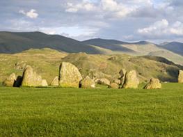
The Northern Fells are less craggy than further south, but high, bare and lonely
Sheep may be present almost anywhere (less likely in winter)
OS Explorer OL 4, OL 5
Several pay car-parks in Keswick; free village car-park by bridge in Caldbeck
In Keswick
<p>From Skiddaw House (Point 4) an escape route goes westward past Dash Falls to Bassenthwaite. This is also an alternative bad weather route to Caldbeck, joining roads near Bassenthwaite.<br /> Public Transport: just one daily bus between Caldbeck and Keswick; additional services on Saturdays</p>
Read our tips to look after yourself and the environment when following this walk.
Discover more than 15,000 professionally rated places to stay, eat and visit from across the UK and Ireland.
Choose a place to stay safe in the knowledge that it has been expertly assessed by trained assessors.
Search by location or the type of place you're visiting to find your next ideal holiday experience.
Read our articles, city guides and recommended things to do for inspiration. We're here to help you explore the UK.