

Draycote Hotel
Located in the picturesque Warwickshire countryside and within easy reach of motorway networks,…

Eathorpe
3.5 miles (5.7kms)
This is a stroll through the attractive hidden villages southeast of Coventry. The route starts at Eathorpe, going near to the River Leam and over pleasant Warwickshire countryside to the historic village of Wappenbury, then crosses the river to Hunningham before returning to Eathorpe along an unclassified road.
The name is derived from ‘ea’ relating to water and ‘thorpe’, which is a common Old Norse suffix that usually denotes a farmstead. The village is sandwiched between the old Fosse Way – the Roman Road that runs from Lincoln to Axminster in Devon – and the River Leam.
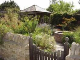
Eathorpe has two halls: the excellent Village Hall (with its small car park) which was built in 2006, and the grander mansion of Eathorpe Hall which is set in secluded parkland south of the village centre. This is a large 18th-century red-brick house once owned by Samuel Shepheard, who built the famous Shepheard’s Hotel in Cairo. Less grandly he also rebuilt the bridge across the River Leam, which bears a commemorative inscription noting its completion date of 1862.
Early records show a variety of names for the village of Wappenbury but it is likely that it means ‘Wappa’s fortified place’. It was certainly once fortified, and the great earthwork ramparts can still be seen here, best preserved on the northwestern and eastern sides. Archaeologists date the great earthwork to the first century AD, some 900 years before the Danish leader Wappa came on the scene. The rampart remains surround the whole village and are believed to be the largest in the Midlands. It is assumed it was constructed to control fords across the River Leam. During excavations, four kilns dating to about AD 350 have been found, along with some items of Roman greyware. We have no reason to doubt that the village thrived into the Middle Ages, but then, like so many others in the area, the plague came, taking the lives of some 200 villagers. Wappenbury has never recovered its original size.
The Church of St John the Baptist has a 15th-century tower, and two coffin lids are the oldest stones in the village. Gravestones and murals make fascinating reading – a mural tablet inside the church here reads: ‘A lingering sickness did me seize And no physician could me ease I fought for help but all in vain Until the Lord did ease my pain.’
From the Village Hall head through the village, initially passing a lovely pair of 17th-century thatched dwellings called Myrtle and Thyme Cottages. At the end of the village the road bends left to pass the old watermill, and crosses the bridge over the River Leam. In 80yds (73m), go right through a kissing gate into pastureland and follow the footpath to the left of the river. You will reach a fence with a distant view of Princethorpe College, with its fine turrets. Cross the stile and aim for the handgate in the far left corner of the field beside a farm gate.
Through the gate, follow the waymarker direction, with the hedge on your right. Continue ahead via a kissing gate at a footpath junction and alongside a hedge, with wooded grounds on the crest ahead. Go through a field gate and continue ahead to a kissing gate to the right of some conifers. Continue alongside trees until you come to a handgate at the road into Wappenbury, to the right of the walls of Wappenbury Hall’s grounds. Turn left along the village road until you come to the front gates of Wappenbury Hall. Go right here towards the Church of St John the Baptist – to its left you will see a fine thatched cottage called Garden Cottage. Walk along the lane to the right of the church and continue right, by a laurel hedge, passing to the right of converted farm buildings. Head back into the open countryside. Go left at a footpath fork through a gate onto a footpath. Descend to a gate onto a single-arch brick bridge, with a second (metal) footbridge beyond it.
Across the River Leam there is about 0.5 miles (800m) of easy walking. Passing through two gates, you reach the road in the village of Hunningham via a bridle gate. To visit The Red Lion pub turn right through the village for about 0.25 miles (400m). The pub garden looks towards the narrow, partly medieval bridge over the River Leam, mostly rebuilt around 1651.
If you do not visit the pub, go left and walk up the farm drive towards Hunningham Farm, signed ‘Leam Lodge and Unclassified County Road’. Continue between the farm buildings, the road now no more than a good stone farm track. After following this road for about 600yds (549m), you will see that it bends to the right about 80 paces ahead of you. Look out for a stile here, leading onto a footpath going off to the left towards the River Leam once again. Walk along the footpath close to the riverbank. From the river the footpath veers right through a kissing gate. Continue along the edge of the field and left at the corner over two stiles. Veer right, and leave the next field over a stile beside an oak tree. Here you are back to the road on the edge of Eathorpe. Go left along the road, passing the entrance to Eathorpe Hall and its lodge to return to the village.
Mainly field footpaths and farm tracks, several stiles
Gentle countryside
Under control at all times
OS Explorer 221 Coventry & Warwick
Village hall car park in Eathorpe or along road near by
None on route
Read our tips to look after yourself and the environment when following this walk.
The sparkle of sunlight on a gentle river as it meanders through beautiful countryside; the reflections of sailing boats on a lake; relaxing with a pint in the garden of an old English pub in a picturesque village; brightly coloured narrow boats making their way through a flight of lock gates; the imposing silhouette of an historic castle. These are the scenes that make Warwickshire a delight.
There may be few seriously high hills in this fertile plain, but it is an area full of attractive walking in rolling countryside, blessed with a fascinating history and wonderful places and buildings to visit. This is Shakespeare’s county, and the footprint of the famous Bard appears almost everywhere. He was born and brought up around the beautiful Warwickshire town of Stratford-upon-Avon, and many of his plays draw upon his own experiences in the area.
Warwickshire has a history that embraces the Civil War, castles and large country houses are scattered over the county. Warwick Castle is the home of the Earl of Warwick, Kenilworth Castle was a stronghold for lords and kings of England in the 11th and 12th centuries, and so the list goes on.
Discover more than 15,000 professionally rated places to stay, eat and visit from across the UK and Ireland.
Choose a place to stay safe in the knowledge that it has been expertly assessed by trained assessors.
Search by location or the type of place you're visiting to find your next ideal holiday experience.
Read our articles, city guides and recommended things to do for inspiration. We're here to help you explore the UK.