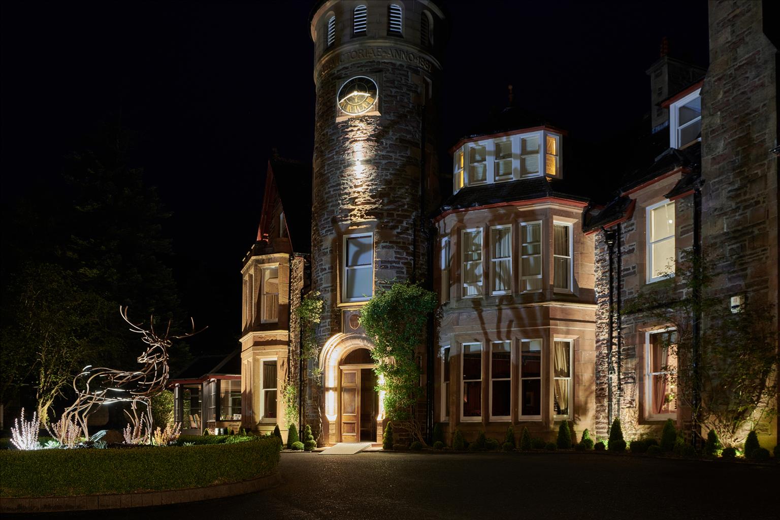
The Torridon
Delightfully set amid inspiring loch and mountain scenery, The Torridon is an elegant Victorian…

Porpoise-watching along the Gairloch shore and up a rocky valley.
Gairloch
5.25 miles (8.4kms)
On a calm day in 1809, three fisherman drowned in Loch Ewe when their small boat was attacked and sunk by a whale. These waters are among the best in Europe for cetaceans (whales, dolphins and porpoises). The Gulf Stream brings warm, plankton-rich water and the swirling currents around the islands bring nutrients to the surface. The plankton flourish; the fish eat the plankton; the whales and dolphins eat the fish.
The strongest currents are at headlands and narrow sea passages, so these are good places to look for marine wildlife. Calm days are best, and early morning best of all when looking west, as the low sunlight shines off their wet backs. On most summer days, either the harbour porpoise or common dolphin – or possibly both – can be seen, given a little patience, in Loch Gairloch. But which is which? At 6ft (2m) or less, the porpoise is smaller. It has a short, stubby fin compared with the dolphin's more elegant one. Harbour porpoises are normally shy, but the ones at Gairloch are untypically friendly, often approaching boats. Endangered in the world as a whole, the ones at Gairloch are doing well.
The whaling industry in Scotland ended in 1951, but serious threats remain. Dolphins and porpoises are accidentally caught in fishing nets, and floating plastic rope and old nets are another danger. Pollution from agriculture and forestry releases heavy metals and pesticides into the ocean. Fish farming is also probably damaging the dolphins. More fish sewage than human sewage goes into the Hebridean seas, all of it untreated, and anti-fouling paint on fish farms contributes more chemicals.
Cetaceans use sound signals for finding fish, as well as for communication. Interference comes from ships, dredging nets, seismic oil exploration and underwater beepers fitted to fish farms to keep seals away.
We don't know how well the dolphins and porpoises are doing. The growth of the whale-spotting industry means that we are just starting to discover how the populations are growing or declining. Marine tourism in Scotland today is a booming trade, supporting several hundred jobs. By going on one of these trips, you'll contribute to crucial research. A responsible boatman will not pursue the animals or steer into the middle of a group, but move quietly and wait for the dolphins to approach the boat.
Cross the road and head up to the right of the newer cemetery. Turn left at its corner, going into trees to a path above. Turn right until a footbridge leads on to a wide path that soon runs downhill. The main path bends right (greentop waymarker) and runs down to a tarred driveway.
Turn left along a tarred track to pass Flowerdale House. The track passes to the left of a lovely old barn and turns right at a sign for Gairloch Trekking Centre.
At the trekking centre keep ahead on a smooth track. Where it bends uphill, keep ahead on a wide path, still to the left of the stream, to reach a footbridge built by the Royal Engineers, just before you get to Flowerdale Waterfall.
The path leads up past the waterfall to cross a footbridge above. It runs up into a windblown pine clump, then turns back down the valley. After another footbridge you pass a memorial to the blind piper of Gairloch, just before you reach a forest road. Turn left, away from the river valley, through felled forest that's regenerating naturally (with birch, alder, pine, willow and rowan).
After 0.5 miles (800m) gently uphill, a footbridge on the right is the start of a path back towards the river. It leads through scrub birch and bracken. The path bends right at an old fence cornerpost and goes down through bracken and birch to reach the valley floor at the corner of a walled paddock. Turn left on a grass track beside the wall, and cross a small stream to join a firm stony track.
Turn left for a few steps, until a small bracken path runs up to the right past a power pole with a faint blue paint mark. At the hilltop the path bends left under oaks, then left again as it drops to rejoin the firm track. This soon meets a larger track, which is the old road from Loch Maree to Gairloch. Turn right along this, through a couple of gates, to reach the Old Inn at Charlestown.
Cross the old bridge, and the main road, towards the pier. Turn right at the signpost for the beach, to a stepped path to the left of Gairloch Wildlife Gallery hut. The tarred path, signed for the beach, turns left above the pier, then turns right into the trees. It bends left again and emerges to run along the spine of a small headland. Just before being carried out to sea it turns sharp right at a signpost, and crosses above a rocky bay to the fort (An Dun). A gravel path runs along the back of the beach, then turns right to the car park.
Tracks and smooth paths, mostly waymarked
Gentle river valley and rocky coast
Keep on lead past Flowerdale House (as signs indicate)
OS Explorer 433 Torridon – Beinn Eighe & Liathach or 434 Gairloch & Loch Ewe
Beach car park, southern end of Gairloch
Walk start and Charlestown pier
Read our tips to look after yourself and the environment when following this walk.
Apart from the Orkneys and the Shetlands, Highland is Scotland’s northernmost county. Probably its most famous feature is the mysterious and evocative Loch Ness, allegedly home to an ancient monster that has embedded itself in the world’s modern mythology, and the region’s tourist industry. Monster or no, Loch Ness is beautiful and it contains more water than all the lakes and reservoirs in England and Wales put together. The loch is 24 miles long, one mile wide and 750 feet deep, making it one of the largest bodies of fresh water in Europe.
At the very tip of the Highlands is John o’ Groats, said to be named after a Dutchman, Jan de Groot, who lived here in the early 16th century and operated a ferry service across the stormy Pentland Firth to Orkney. In fact, the real northernmost point of the British mainland is Dunnet Head, whose great cliffs rise imposingly above the Pentland Firth some two miles further north than John o’ Groats.
The Isle of Skye is the largest and best known of the Inner Hebrides. Its name is Norse, meaning ‘isle of clouds’, and the southwestern part of the island has some of the heaviest rainfall on the whole of the British coast. Despite this, it’s the most visited of all the islands of the Inner Hebrides. It’s dominated from every view by the high peaks of the Cuillins, which were only conquered towards the end of the 19th century.
Discover more than 15,000 professionally rated places to stay, eat and visit from across the UK and Ireland.
Choose a place to stay safe in the knowledge that it has been expertly assessed by trained assessors.
Search by location or the type of place you're visiting to find your next ideal holiday experience.
Read our articles, city guides and recommended things to do for inspiration. We're here to help you explore the UK.