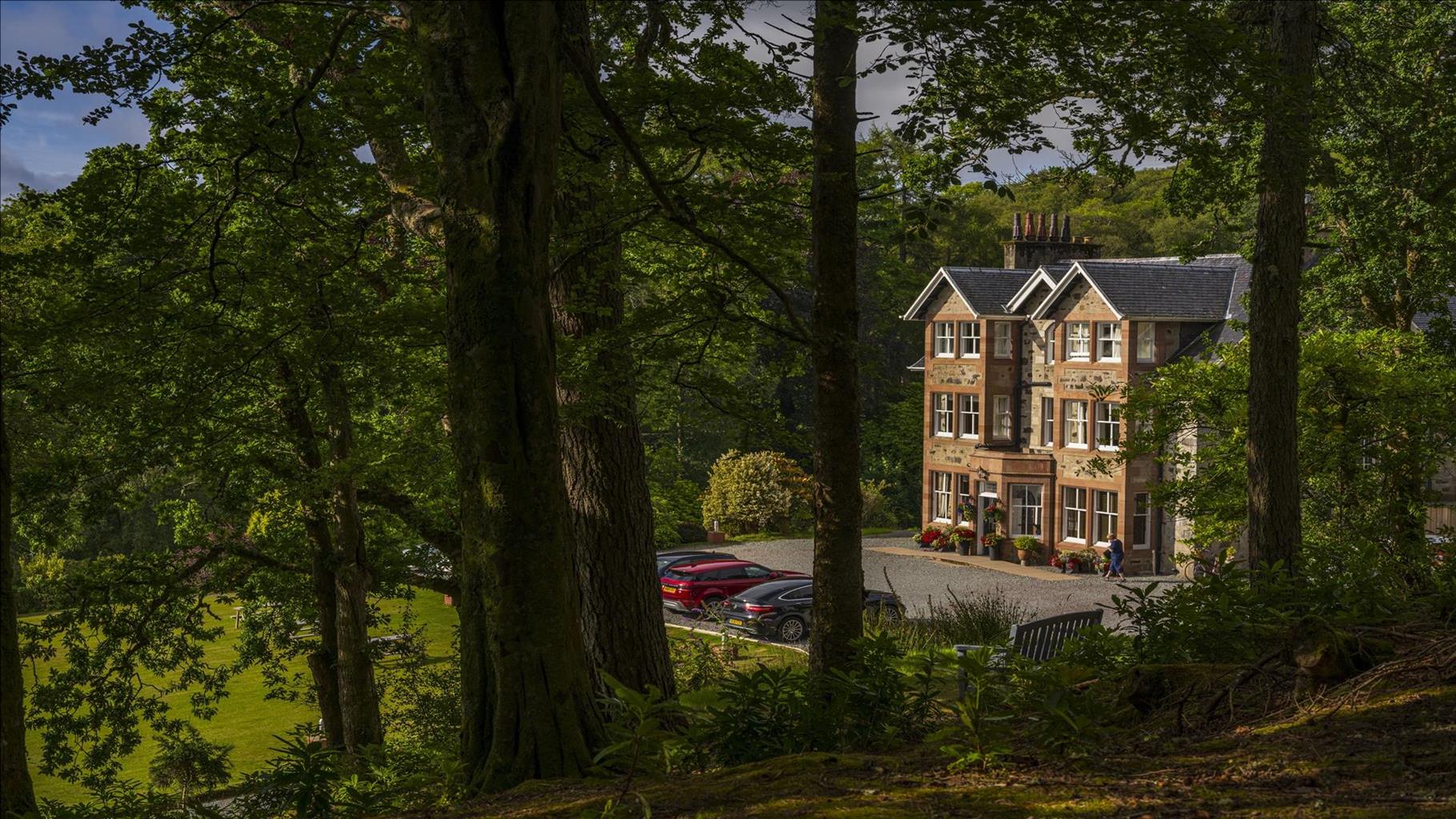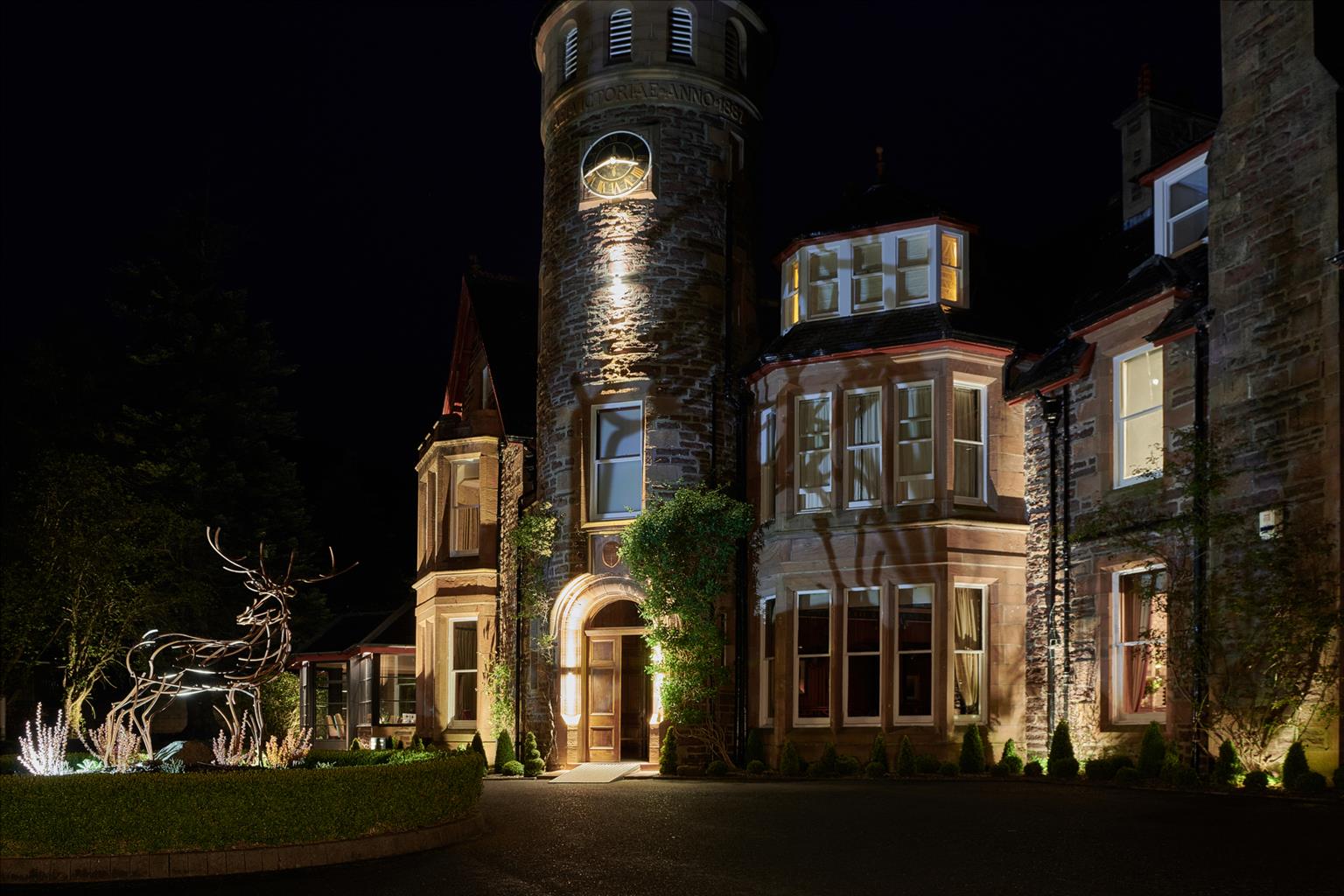
The Torridon
Delightfully set amid inspiring loch and mountain scenery, The Torridon is an elegant Victorian…

A walk above Loch Torridon in the footsteps of the fairy folk – the legendary Duine Sithe
Loch Torridon
9.9 miles (15.9kms)
New Year's Eve in Wester Ross is a time when old songs are sung, whisky is drunk (not all of it approved by the exciseman either) and tales are told in both English and Gaelic. Over the years these stories mature and grow, and also change location, so that the tailor who lost his hump to the fairies lived not only in Scotland, but in Ireland and even Italy.
Many of the tales told in Alligin take place in the knolly, magical ground on the way to Diabaig. One story concerns two villagers who were bringing whisky for the New Year from Gairloch by way of the coast path. They heard wonderful music and came upon a cave in the hill where the fairy people had started their Hogmanay celebrations a few hours early. Fascinated, the man with the keg crept closer and closer until he was actually inside, whereupon the cave closed up and disappeared. A year later the other man came back, found the cave open and dragged his friend out across the threshold. The friend thought he'd been in there only a few minutes, but of the whisky he carried there was no trace.
At the top of the hill road is tiny Lochan Dearg, and here there is a ghost that appears only to people bearing his own name, Murdo Mackenzie. The kilted spirit, one of the Mackenzies of Gairloch, was slain by a Torridon MacDonald and buried somewhere near by.
Loch Diabaigas Airde (Point 3) is haunted by the water spirit called the kelpie. This appears as a magnificent white horse, but if you mount it, the horse gallops rapidly into the loch and you're never seen again. That is, unless you just happen to have a bridle that's made of pure silver to tame it. Another kelpie lives in the Lochan Toll nam Biast, the Lochan of the Beast Hole, at the back of Beinn Alligin.
Fairy music has been heard above the gorge of the Alligin burn. So, to protect yourself from the Duine Sithe, be polite, but don't accept food from them. At best it'll be cow dung, at worst it'll enslave you for ever. Carry iron, oatmeal or a groundsel root for protection, and a cry of 'am monadh oirbh, a' bheistein' ('back to the hill, you wee beastie') is effective. Approaching Wester Alligin, walk carefully past Cnoc nan Sithe, the Fairy Knoll, so as not to disurb them.
From the parking place, follow the road over the Abhainn Alligin river. A path leads along the shoreline for 100yds (91m) and then makes its way up right among sandstone outcrops. Bear left underneath a power line to join the corner of a tarmac driveway. Keep ahead to reach Wester Alligin.
Turn right up the road and then left, on the road for Diabaig. The road steepens as you continue along the road (although you can take a path to the right of power lines), across a high pass, with superb views (Bealach na Gaoithe Viewpoint) and then down past two lochs – Loch Diabaigas Airde and Loch a’Mhullaich – which are linked.
Turn off left, crossing the outflow of Loch a’ Mhullaich on a footbridge. A clear path leads out along the high wall of a stream valley, then zig-zags down to a grey gate. Go down through woods to a white house, No 1 Diabaig. Turn right to reach the old stone pier.
Return up the path you just came down to pass a stone shed. Here a sign indicates a turn to the right, under an outcrop and between boulders. The path heads up to a small rock step with an arrow mark and a convenient tree root which you can use to hold on to. It then leads up to a gate in a fence and zig-zags into an open gully with a large crag on the right. At the top of this, it turns right along a shelf, with still more crag above. The path slants gently down along the foot of another crag, then up to a col.
From here the path is small but clear. It bends right to Loch a’ Bhealaich Mhoir and then turns left below it to Lochan Dubh. Cross its outbound flow and slant down left towards the cottage of Port Laire.
Pass above the house, then slant gradually up away from the sea. The path crosses the head of a bracken valley with a ruined croft house into a bleak knolly area out of sight of the sea. Cross two branches of a stream and go up to a cairn which marks where the path bears left up the spur. It now contours across a heathery meadow among the knolls, at the end of which it climbs pink rocks over a final spur. Just ahead is a gate in the deer fence.
The path leads along a level shelf with views to Liathach and the head of Loch Torridon, then it crosses a high, steep slope of heather. Near the end of this slope, the path forks. Take the upper branch, to go through a wide col. The rather boggy path heads down towards Wester Alligin. From a gate above the village, a faint path runs down in the direction of a distant green shed. It descends through a wood, then contours just above the village to reach the road above Point 2. Retrace your steps to the start of the walk.
Narrow, rough and wet in places
Rocky knolls and small lochans
Keep on lead passing Wester Alligin and near sheep
OS Explorer 433 Torridon – Beinn Eighe & Liathach
Inveralligin, pull-in on side road near Alligin River
Torridon village
Read our tips to look after yourself and the environment when following this walk.
Apart from the Orkneys and the Shetlands, Highland is Scotland’s northernmost county. Probably its most famous feature is the mysterious and evocative Loch Ness, allegedly home to an ancient monster that has embedded itself in the world’s modern mythology, and the region’s tourist industry. Monster or no, Loch Ness is beautiful and it contains more water than all the lakes and reservoirs in England and Wales put together. The loch is 24 miles long, one mile wide and 750 feet deep, making it one of the largest bodies of fresh water in Europe.
At the very tip of the Highlands is John o’ Groats, said to be named after a Dutchman, Jan de Groot, who lived here in the early 16th century and operated a ferry service across the stormy Pentland Firth to Orkney. In fact, the real northernmost point of the British mainland is Dunnet Head, whose great cliffs rise imposingly above the Pentland Firth some two miles further north than John o’ Groats.
The Isle of Skye is the largest and best known of the Inner Hebrides. Its name is Norse, meaning ‘isle of clouds’, and the southwestern part of the island has some of the heaviest rainfall on the whole of the British coast. Despite this, it’s the most visited of all the islands of the Inner Hebrides. It’s dominated from every view by the high peaks of the Cuillins, which were only conquered towards the end of the 19th century.
Discover more than 15,000 professionally rated places to stay, eat and visit from across the UK and Ireland.
Choose a place to stay safe in the knowledge that it has been expertly assessed by trained assessors.
Search by location or the type of place you're visiting to find your next ideal holiday experience.
Read our articles, city guides and recommended things to do for inspiration. We're here to help you explore the UK.