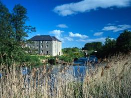


Barmoor Ridge Cottage & The Old Farmhouse
Set near Lowick, just a few miles from the coast and Holy Island, Barmoor Ridge Cottage and the…

Ford Moss
7 miles (11.3kms)
Tucked beneath Goatscrag Hill, Ford Moss began as a shallow lake created at the end of the last ice age. Encroaching vegetation, however, gradually turned the hollow into marsh, and over time the accumulation of dead matter created an ever-deepening layer of peat to become a raised bog. The formation rests on water and is fringed by marsh and fen, but because the surface is very soft, it is dangerous to cross. However, the perimeter path used for this walk gives fine views over the mire.
Such habitats are uncommon in Britain, and since 1968 Ford Moss has been designated an SSSI. Encompassing some 148 acres (60ha), the area supports a wealth of vegetation and wildlife. In the wetter areas, patches of cotton grass, easily recognised by white fluffy seed heads sway above a carpet of sphagnum mosses, which retains water like a massive sponge. Take a pair of binoculars along, for the bog attracts many birds. You might spot snipe probing the wetter areas with their long, straight beaks; or possibly woodcock, a more stocky wader with reddish legs, although during the day they tend to remain under cover. Look out, too for, kestrel or perhaps the much larger buzzard, which patrol the skies above.
Until the early 20th century, the area was mined for coal, and old shafts and spoil heaps dot the surrounding landscape. Not surprisingly, water seeping from the moss was a problem and eventually steam pumps were installed to drain the workings and allow the exploitation of deeper seams. The tall chimney and engine house are now all that remain.
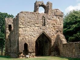
The route returns past the impressive prehistoric rock carvings of Routin Lynn. Variously spelled, the name refers to a nearby waterfall and means 'roaring pool', a natural feature that might have had special significance to the people who created the carvings. There are numerous examples of cup-and-ring marks in Northumberland, but this great whaleback of rock is by far the largest and most profusely carved. Discovered in 1852, the enigmatic carvings consist of patterns of cup-shaped hollows, concentric circles and grooves, and there is also a tether cut into the rock. More than 4,000 years old, the carvings are associated with a period known as Beaker culture, named for the pottery containers or beakers that have been found at various sites and which had all manner of uses including the interment of funerary ashes.
From Lady Waterford Hall, walk east up the main street and turn right in front of Jubilee Cottage to the main road. Turn left, crossing after 150yds (137m) to a track on the right signed to Ford Hill. At a waymarker just beyond a gate, leave left on a narrow woodland path. Emerging beyond, a contained path leads down to a stile. Strike half left across the hillside, crossing an old hedged bank to a field gate near the far bottom corner.
Go over a stream and walk on above more woodland. Carry on in a second field, but after 75yds (69m) pass right through a gateway, dropping between trees to a crossing track. Through a gate opposite, head out along the rising fold of the field, the way signed to Ford Moss. Maintain the same line in the next field, leaving through a gate at the top onto a narrow lane. Walk left for 150yds (137m) before doubling back right on a rising track, which leads into the Ford Moss Nature Reserve.
At a junction near the interpretation panel, keep left to pass through a gate. Stay with the main path, curving above the northern edge of the moss. Go over a stile and carry on by the left fence past the engine house to a stile in the corner. Walk on past trees, soon mounting another stile to continue with the fence again on your left. Beyond a couple of gates and a footbridge, leave the nature reserve and walk through rough pasture. Keep going by the left fence. Eventually approaching the corner, watch for a gate by a powerline post.
Veer right, soon joining the end fence to the next corner. Pass through the left gate and swing right beside the fence beside more open grazing. Ultimately, beyond a hillock, bear left through a gate onto a lane.
Follow the lane right for 0.75 miles (1.2km), cresting a rise and descending into woodland. About 75yds (69m) before a junction, look for a narrow path on the right that leads to the Routin Lynn rock.
Return to the lane, go right to the junction and right again along a bridleway to Routin Lynn Farm and Goatscrag. When the track finally swings into the farmyard, keep ahead through a gate to pass below Goatscrag cliffs.
Go through another gate at the far end of the crag and turn off right on a path through bracken onto the hill. At the top curve left along the broad ridge. Keep right at two successive forks, soon losing height towards the chimney at the foot of the moss. After dropping between trees, go through a gate and past the chimney back to the junction crossed earlier, near the interpretation panel. Keep ahead and retrace your outward route across the fields to Ford.
Field paths, tracks and lane, 4 stiles
Cultivated fields and moorland grazing
Grazing livestock, keep dogs on leads
OS Explorer 339 Kelso & Coldstream
Street parking in Ford
In Ford village
Read our tips to look after yourself and the environment when following this walk.
If it’s history you’re after, there’s heaps of it in Northumberland. On Hadrian’s Wall you can imagine scarlet-cloaked Roman legionaries keeping watch for painted Pictish warriors while cursing the English weather and dreaming of home. Desolate battlefield sites and hulking fortresses such as Alnwick, Dunstanburgh, Bamburgh and Warkworth are reminders that this, until not so very long ago, was a contested border region. The ruins of Lindisfarne bear witness to the region’s early Christian history.
Northumberland also has some of Britain’s best beaches. On summer days, and even in winter, you’ll see surfers and other brave souls making the most of the coast. Inland, there are some great walks and bike rides in the dales of the Cheviot Hills and the Simonsides – just hilly enough to be interesting, without being brutally steep. There's dramatic scenery in the High Pennines, where waterfalls plunge into deep valleys, and there are swathes of heather-scented moorland. Northumberland National Park covers over 400 square miles of moorland and valleys with clear streams and pretty, stone-built villages. It’s just the place for wildlife watching too. You’ll find flocks of puffins, guillemots and other seabirds around the Farne Islands, and seals and dolphins offshore.
Discover more than 15,000 professionally rated places to stay, eat and visit from across the UK and Ireland.
Choose a place to stay safe in the knowledge that it has been expertly assessed by trained assessors.
Search by location or the type of place you're visiting to find your next ideal holiday experience.
Read our articles, city guides and recommended things to do for inspiration. We're here to help you explore the UK.