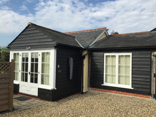


Wakes Hall Lodges
Luxury 1 and 2-bedroom single-storey lodges completed in 2013 to a high specification, including…

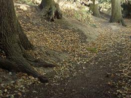
A fairly challenging walk along a disused railway track, now a nature reserve, and through ancient woodland.
Earls Colne
5 miles (8kms)
Is this the prettiest valley in all Essex? Judge for yourself as you follow the meandering River Colne and visit the village of Earls Colne, where the de Vere family – Earls of Oxford and one of the greatest families in English history – left their name. Here you will find a lovely view from the split-timber seating beside St Andrew’s Church, with its tower visible for miles around; a nature reserve along a disused railway track, which has been cut back allowing wildlife to flourish; and the ancient trees of Chalkney Wood.
The Colne Valley Railway opened in 1860 and soon brought prosperity to the valley. Earls Colne, one of the stations on the line, was built by the Hunt family who developed the Atlas Works, which produced farming equipment until it closed in 1988. The line was used to import raw materials and to despatch the finished product, but since its closure in 1965 the trackside vegetation has become a rich habitat for wildlife, with plenty of trees and shrubs providing heavy shade. As you walk along the disused track you will see evidence of coppicing which allows light to reach the ground, which in turn allows wildlife such as butterflies and other insects to proliferate.
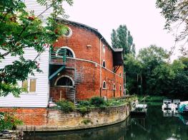
Chalkney Wood dates back to 1605, when it was owned by the de Vere family. This walk takes you through the woods where conifers are gradually being replaced with traditional species. You'll also see, near the kennels, an 18th-century watermill which last worked in the 1930s and is now a private residence. In the Alder Valley are the remains of conifer plantations established in the 1960s, but today the area supports more moss and liverworts than any other wood in East Anglia. You'll also pass close to the Wool Track, believed to be an ancient Roman road linking Colchester and Cambridge, and come across a prominent bank which enclosed the woods as a swine park where pigs would feed on acorns amongst the coppice.
Brickfields and Long Meadow Nature Reserve, bordered by woodland of oak, ash and hawthorn, has plenty of boggy areas and wet grassland. It is small, but teems with insect life. The ponds, surrounded by acacia and rhododendron, are home to newts, frogs and dragonflies. A major feature of the area is the anthills, which house huge colonies of yellow ants. Long Meadow, used for grazing, is free of fertilisers and pesticides, and as a result supports wildlife and a variety of grasses such as yarrow and birds-foot trefoil.
From the car park turn left, and left again into Burrows Road. Turn right, cross a road called Hillie Bunnies and keep ahead to climb a stile beside a public footpath sign. Follow the path downhill across the golf course, passing to the left of a pond, to reach a yellow waymark beside a footbridge. Cross this and bear left towards a hedge gap along a grassy path, to join the railway nature reserve. Turn right onto the railway embankment and maintain direction, keeping the river and golf course on your right. Cross the footbridge over the River Peb and maintain your direction for about 600yds (549m).
Leave the reserve by turning right at a collection of waymarks. Keep the fence of the sewage works on your left and follow the grassy path, which later becomes a tarmac road, and pass through a kissing gate to reach Lower Holt Street. Turn left, cross the road, and follow the footpath and waymark between house Nos. 20 and 22 through the wooden gate. Maintain direction across the meadow with the River Colne down on your right, and go through two more gates.
Turn right and cross the bridge over the Colne, passing kennels and Chalkney Mill on your right, and maintain direction into Chalkney Wood. Keep ahead at a crossing of paths, and follow the track as it curves right to a parking area. Continue along the wide, downhill track for 300yds (274m) and turn left into Tey Road at Peek's Corner.
After 300yds (274m) turn right at the public footpath sign and go along the field-edge path, keeping the hedgerows on your right. Cross the earth bridge through trees, maintain direction uphill, and pass Tilekiln Farm House, on your right, to reach Coggeshall Road.
Turn right at Coggeshall Road, and as the road curves right, turn left at the public footpath sign marked Park Lane. Follow the path, ignoring the first kissing gate where the houses end on the right. Go through the next kissing gate and turn immediately right along the path bounded by thick gorse bushes. Follow the path along the right-hand edge of woodland to a stile. Do not go over this but turn left beside a stream. Go through a kissing gate and walk along the field-edge path, keeping the hedgerow on your right, to an earth bridge where you turn right over the stream.
Take the path past a Brickfields information board on your right, and turn right at the top into Park Lane, with St Andrew's Church on your left. Turn left through the churchyard, passing beside the lych gate to reach the High Street, and return to the car park.
Grassy with some muddy tracks, forest and field-edge paths
Disused railway line, ancient woodland, riverside and grazing meadows
On a lead near the kennels
OS Explorer 195 Braintree & Saffron Walden
Free parking at Queens Road car park in Earls Colne
Queens Road car park
Read our tips to look after yourself and the environment when following this walk.
Essex is full of pleasant surprises. It has the largest coastline of any county in England, with its fair share of castles, royal connections and scenic valleys. Take Colchester, for example, which was built by the Romans and is Britain’s oldest recorded town. Its castle contains the country’s largest Norman keep and yet, a stone’s throw from here, East Anglia’s newest arts centre promises to put Colchester firmly on the map as Essex’s capital of culture.
Tidal estuaries are plentiful and their mudflats offer migrating birds a winter feeding place. Essex was known as the land of the East Saxons and for centuries people from all over Europe settled here, each wave leaving its own distinctive cultural and social mark on the landscape. Walking a little off the beaten track will lead you to the rural retreats of deepest Essex, while all over the county there are ancient monuments to explore:
Discover more than 15,000 professionally rated places to stay, eat and visit from across the UK and Ireland.
Choose a place to stay safe in the knowledge that it has been expertly assessed by trained assessors.
Search by location or the type of place you're visiting to find your next ideal holiday experience.
Read our articles, city guides and recommended things to do for inspiration. We're here to help you explore the UK.