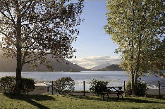


The Glencoe Inn
This welcoming inn has a stunning location in the shadow of the Pap of Glencoe overlooking Loch…

A rugged waterfall walk into the hidden hollow where the MacDonalds hid their stolen cows.
Glen Coe
2.75 miles (4.4kms)
The romantically named Lost Valley is 'Coire Gabhail' in Gaelic, the 'Corrie of Booty'. Here, during the centuries leading up to the famous massacre of 1692, the MacDonalds hid their stolen cattle when the owners came storming in over the Moor of Rannoch with torch and claymore. It seems incredible that even the sure-footed black cattle of the clans could have been persuaded up the slope to Coire Gabhail. The corrie entrance is blocked by two old landslides from the face of Gearr Aonach, the middle hill of Glen Coe's Three Sisters.
The economic system of Highland Scotland, until 1745, was based on the keeping and the stealing of cattle. It was an unsettled and dangerous lifestyle, and its artform was the verse of the bard who celebrated the most ingenious or violent acts of thievery and kept track of blood feuds. The clan, gathered under its chieftain, was an organisation for protecting its own glen and for stealing from its neighbours. The MacDonalds of Glen Coe were particularly good at it. They raided right across the country, passing the fringes of the Cairngorms to steal from Aberdeenshire and Moray. In 1689, when Campbell of Glen Lyon was a guest in the house of MacIan, chief of Glen Coe, his cold blue eyes may have dwelt on a particular cooking pot. Twice in the previous 10 years, MacIan had come raiding into Glen Lyon, dishonoured the women by cutting off their hair and, on the second occasion, stolen that pot from Campbell's own mother.
By the late 1600s, the clan and the claymore were being replaced by a legal system backed by the central government and its army. But because they were so good at cattle thieving, the MacDonalds of Glen Coe continued the practice long after everyone else had reluctantly started to move into the modern world of cash. As a result, the government decided to make an example of them.
On a cold February day, a squad of soldiers arrived in the valley. Traditional hospitality meant that even its leader from Glen Lyon, a Campbell and an enemy, was welcomed into the house of MacDonald. Five nights later, at a given signal, the soldiers rose and murdered their hosts. The Glen Coe Massacre was either incompetent or mercifully half-hearted. Of the valley's population of 300, just 40 were killed, with the remainder escaping through the snow to the Lost Valley and other high corries.
From the uphill corner of the car park, a faint path slants down to the old road, which is now a well-used wide path. Head up the valley for about 650yds (594m). With the old road continuing as a green track ahead, the main path now bends down to the right. It has been rebuilt, with the bog problem solved by scraping down to the bedrock. The path reaches the gorge where the River Coe runs in a geological dyke of softer rock. Descend here on a steep metal step ladder, to cross a spectacular footbridge.
The ascent out of the gorge is on a bare rock staircase with safety cable (in winter this can be solid ice). Above, the path runs through regenerated birch wood; sheep and deer have been excluded from the wood with a temporary fence. Emerge from this through a high gate. The path, rebuilt in places, runs uphill for 60yds (55m). Here it bends left; an inconspicuous alternative path continues uphill, which can be used to bypass the narrow path of the main route.
The main route contours into the gorge of the Allt Coire Gabhail. It is narrow with steep drops below. Where there is an alternative of rock slabs and a narrow path just below, the slabs are more secure. You will hear waterfalls, then two fine ones come into view ahead. After passing these, continue between boulders to where the main path bends left to cross the stream below a boulder the size of a small house. (A small path runs on up to the right of the stream, and bends downhill above the gorge back to the junction with the main path, passed earlier.) The river here is wide and fairly shallow. Five or six stepping-stones usually allow dry crossing. If the water is above the stones, then it's safer to wade alongside them; if the water is more than knee-deep the crossing should not be attempted.
A well-built path continues uphill, now with the stream on its right. After 100yds (91m) a lump of rock blocks the way. The path follows a slanting ramp up its right-hand side. It continues uphill, still rebuilt in places, passing above the boulder pile that blocks the valley, the result of two large rockfalls from under Gearr Aonach opposite. At the top of the rockpile the path levels, giving a good view into the Lost Valley.
Drop gently to the valley's gravel floor. The stream vanishes into the gravel, to reappear below the boulder pile on the other side. Note where the path arrives at the gravel, as it becomes invisible at that point. Wander up the valley to where the stream vanishes, 0.25 miles (400m) ahead. Anywhere beyond this point is more serious hillwalking than you have done up to now on this walk. Return to the path and follow it back to the start of the walk.
Rugged and stony, stream to wade through
Crags and mountains
Dogs must be reasonably fit and agile, especially for steep ladder steps at River Coe
OS Explorer 384 Glen Coe & Glen Etive
Lower of two roadside parking places opposite Gearr Aonach (middle one of the Three Sisters)
Glencoe NTS Visitor Centre
Read our tips to look after yourself and the environment when following this walk.
Apart from the Orkneys and the Shetlands, Highland is Scotland’s northernmost county. Probably its most famous feature is the mysterious and evocative Loch Ness, allegedly home to an ancient monster that has embedded itself in the world’s modern mythology, and the region’s tourist industry. Monster or no, Loch Ness is beautiful and it contains more water than all the lakes and reservoirs in England and Wales put together. The loch is 24 miles long, one mile wide and 750 feet deep, making it one of the largest bodies of fresh water in Europe.
At the very tip of the Highlands is John o’ Groats, said to be named after a Dutchman, Jan de Groot, who lived here in the early 16th century and operated a ferry service across the stormy Pentland Firth to Orkney. In fact, the real northernmost point of the British mainland is Dunnet Head, whose great cliffs rise imposingly above the Pentland Firth some two miles further north than John o’ Groats.
The Isle of Skye is the largest and best known of the Inner Hebrides. Its name is Norse, meaning ‘isle of clouds’, and the southwestern part of the island has some of the heaviest rainfall on the whole of the British coast. Despite this, it’s the most visited of all the islands of the Inner Hebrides. It’s dominated from every view by the high peaks of the Cuillins, which were only conquered towards the end of the 19th century.
Discover more than 15,000 professionally rated places to stay, eat and visit from across the UK and Ireland.
Choose a place to stay safe in the knowledge that it has been expertly assessed by trained assessors.
Search by location or the type of place you're visiting to find your next ideal holiday experience.
Read our articles, city guides and recommended things to do for inspiration. We're here to help you explore the UK.