

Cragside Cottage
Awaiting description.

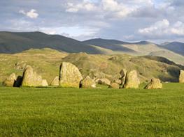
Rolling grassy fells offer quiet solitude and an air of intrigue.
Souther Fell
5.25 miles (8.4kms)
With an air of the theatrical, the little River Glenderamackin weaves a circuitous course around Souther (pronounced sue-ter) Fell, passing through, on its meanderings, the little hamlet of Mungrisdale (pronounced mun-grizedale). Whereas the central Lakeland fells are composed of hard volcanic rocks, Souther Fell and its neighbouring hills are made up of the relatively soft rocks of Skiddaw slate. The resultant smooth and rounded terrain of this mountain region gives an air of wild desolation. On this walk, a long gradual ascent following the river provides an easy way to climb Souther Fell. The rewards, once the heights are crested, are expansive views east over the plains of the Eden Valley, and behind to the dark crags and combes of Bannerdale Crags and the great Blencathra mountain.
The majority of place-names in these parts are Celtic; Mungo (a Celtic missionary), Blencathra and Glenderamackin are typical examples. Indeed, the remains of an important Celtic hill-fort still form a defensive ring around the nearby summit of Carrock Fell just to the north, and it is thought that northern Cumbria was still part of the Kingdom of Strathclyde in the 10th century.Phantom army
Locals have long said that a ghostly army of warriors marches over Souther Fell on Midsummer’s Eve, a legend that goes back to 1745, the year Bonnie Prince Charlie returned to march on England. Following reports that both soldiers and horsemen had been seen marching along the high shoulder of Souther Fell, a group of 26 local men stationed themselves at a suitable vantage point in the valley below on the evening before midsummer, determined to put to rest the rumours and speculation. To their incredulity they witnessed a rapidly moving line of troops, horses and carriages. The line spread right across the high summit shoulder of the fell in a continuous chain. Steep places and rocky outcrops neither slowed nor disrupted progress of this huge army. They couldn’t believe their eyes – yet only darkness put an effective end to these strange events. The next day there was nothing to be seen so, with considerable trepidation, half-expecting that the invasion from over the border had begun, a party climbed to the summit – where they found nothing. Not a mark in the grass, no footprint, hoof-print or wheel rut, and of an army there was not the remotest sign. So convinced were the 26 men, and determined that their integrity should be respected, that they all swore an oath before a magistrate as to what they had seen. It remains a mystery, yet Bonnie Prince Charlie was to invade in the November of that same year.
With your back to the parking area, turn left along the road, following the River Glenderamackin upstream. After passing a lane to the Mill Inn on the left, go left, past a red telephone kiosk, to follow a little lane between the cottages. Continue along the rough track above the north bank of the river. Follow the footpath as it bends away from the river and passes through a boggy area on a path of slate slabs before returning to cross Bullfell Beck on a footbridge.
A few paces beyond Bullfell Beck, as the main track starts to climb steeply, bear left along a lesser path that traces a route along the west bank of the Glenderamackin. The going is straightforward, although the path has been eroded in places and there is a steep drop down to the little river. Continue along the track, boggy in places, to ford Bannerdale Beck. Continue above a fenced area of tree-planting and round the shoulder of Bannerdale Crags, intriguingly named White Horse Bent by the Ordnance Survey. Continue the ascent until a narrow trail drops left to a footbridge to cross the River Glenderamackin, which is hardly 6ft (2m) wide at this point.
Follow the path (with frequent glances back at the dramatic form of Blencathra) as it ascends diagonally left to a high grassy saddle. Bear left, following the path and ascend the long shoulder of Souther Fell. In a slight dip, fork left to a prominent cairn for a superb view of Blencathra and Bannerdale Crags. Bear right back to the main path and continue, through another gentle dip, to a rise capped by a few rocks: the summit.
Keep north and continue to descend the grassy nose of the fell. Easy at first, the angle steepens progressively. Follow the path carefully to negotiate a little crag. A few dozen strides after this rocky section, and just before a gap through another area of bare rock, bear right at a faint fork in the path. A trail, obscured in summer by high bracken, slants down right towards a clump of tall conifers. Continue beside a fence until it meets a road near the trees.
Go left down the road, through a gate, until you reach the Mill Inn’s car park. Immediately take the signposted path to the right that drops to cross another relatively new bridge over the Glenderamackin. The car park where the walk started is now on the left.
Grassy and stony paths, open fellside
Remote river valley, open exposed fellside
Under control at all times; whole area grazed by sheep
OS Explorer OL5 The English Lakes (NE)
Car park opposite village hall (with honesty box)
None on route
Read our tips to look after yourself and the environment when following this walk.
Cumbria's rugged yet beautiful landscape is best known for the Lake District National Park that sits within its boundaries. It’s famous for Lake Windermere, England’s largest lake, and Derwent Water, ‘Queen of the English Lakes'. This beautiful countryside once inspired William Wordsworth and his home, Dove Cottage, in Grasmere is a popular museum. Another place of literary pilgrimage is Hill Top, home of Beatrix Potter, located near Windermere. Tom Kitten, Samuel Whiskers and Jemima Puddleduck were all created here.
Much of Cumbria is often overlooked in favour of the Lake Distirct. In the south, the Lune Valley remains as lovely as it was when Turner painted it. The coast is also a secret gem. With its wide cobbled streets, spacious green and views of the Solway Firth, Silloth is a fine Victorian seaside resort. Other towns along this coastline include Whitehaven, Workington and Maryport. Carlisle is well worth a look – once a Roman camp, its red-brick cathedral dates back to the early 12th century and its 11th-century castle was built by William Rufus.
Discover more than 15,000 professionally rated places to stay, eat and visit from across the UK and Ireland.
Choose a place to stay safe in the knowledge that it has been expertly assessed by trained assessors.
Search by location or the type of place you're visiting to find your next ideal holiday experience.
Read our articles, city guides and recommended things to do for inspiration. We're here to help you explore the UK.