"Lepers, Conservators and Civil War skirmishes all play their part on this walk around Devon’s ‘Cavalier Town’."
Walk directions
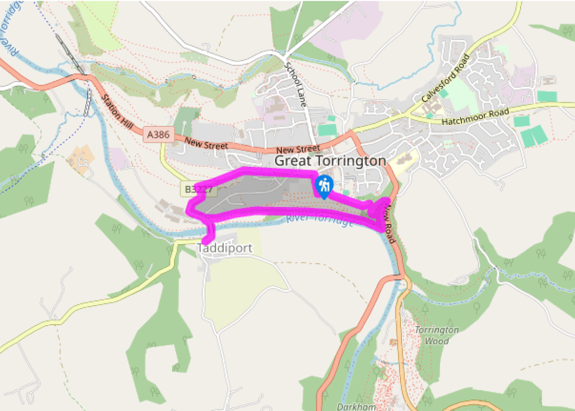
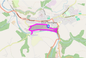
Facing the steps of the tourist information centre, turn right and walk along the wall to go through an archway in the far corner of the car park.
Turn left on a tarmac path, past high mid-19th-century castellated walls built by John, Lord Rolle. Pass another car park and a picnic area, with good views ahead towards Rosemoor Garden. The path (George’s Path) starts to descend slightly.
On meeting a grassy area with a seat ahead, turn right downhill, heading towards a stone obelisk commemorating the Battle of Waterloo (1815). At the monument turn left and follow a tarmac path downhill into woodland.
As the path bears right towards a road, turn right down steps and follow the broad path (Lady Wash) downhill to meet a track on the bank of the River Torridge.
Turn right on this broad track under lofty oaks (particularly lovely in spring and autumn) on the former Rolle Canal, opened in 1827 to improve transport links from the coast inland. This section was filled in and became a toll road, while part of its course was sold to the London and South Western Railway, which reached Great Torrington in 1872. At a gate ahead turn left down steps onto a narrow path close to the river. Where the river curves away left, keep ahead through a barrier and onto the track.
Immediately turn left onto Ladies Island. Keep along the left edge to regain the river, then follow it to cross a stile onto the road by Taddiport Bridge.
To visit the Chantry Chapel of the Leper Hospital of St Mary Magdalene, turn left over the bridge and follow the road; the chapel is on the right. Retrace your steps over the bridge and follow the road, bearing left past the Torridge Inn and the old Tannery, opposite the disused milk factory. Ascend Limers Hill to enter the Commons.
At the second footpath sign (right) turn right and take the left (higher) of two paths, climbing steadily to reach Warren Lane. Turn right, and where the lane bears right downhill, keep ahead through railings into Rack Park (so-named from the days when fleeces and woven cloth were laid on racks to dry in the sun). Exit the park onto Mill Street, then cross into South Street and keep ahead to return to the car park.
The market town of Great Torrington, perched on a bluff overlooking a bend of the River Torridge, is a fascinating place to visit, and this walk touches on a different historic period or event at every turn. It’s worth noting that this short walk experiences a long descent at the start, and a... correspondingly long climb back at the end – but the ascent in particular is steady and enjoys lovely views. A level section leads along the banks of the River Torridge, which rises near the north Cornish coast and follows a curious route east before turning north to eventually join the Taw at Appledore. A Cavalier town The town witnessed two important clashes in 1642 and 1643, and was the site of the last major battle of the Civil War in February 1646, when more than 10,000 troops were involved. The Royalists, who had barricaded the town, were finally driven out by Parliament’s New Model Army under Sir Thomas Fairfax and Oliver Cromwell.
Devon sums up all that is best about the British landscape, with its magnificent coastlines, two historic cities, the world-famous Dartmoor National Park and south Devon’s glorious English Riviera. A fashionable and much-loved holiday destination, hiking and cycling in the National Parks is extremely popular among visitors, with a great choice of off-road routes.
"Lepers, Conservators and Civil War skirmishes all play their part on this walk around Devon’s ‘Cavalier Town’."
Walk details
1hr 15min
Difficulty:
Medium
Gradient:
Moderate
Distance:
2.25 miles (3.6kms)
Ascent:
279ft (85m)
Walk directions
Facing the steps of the tourist information centre, turn right and walk along the wall to go through an archway in the far corner of the car park.
1 of 8
Turn left on a tarmac path, past high mid-19th-century castellated walls built by John, Lord Rolle. Pass another car park and a picnic area, with good views ahead towards Rosemoor Garden. The path (George’s Path) starts to descend slightly.
2 of 8
On meeting a grassy area with a seat ahead, turn right downhill, heading towards a stone obelisk commemorating the Battle of Waterloo (1815). At the monument turn left and follow a tarmac path downhill into woodland.
3 of 8
As the path bears right towards a road, turn right down steps and follow the broad path (Lady Wash) downhill to meet a track on the bank of the River Torridge.
4 of 8
Turn right on this broad track under lofty oaks (particularly lovely in spring and autumn) on the former Rolle Canal, opened in 1827 to improve transport links from the coast inland. This section was filled in and became a toll road, while part of its course was sold to the London and South Western Railway, which reached Great Torrington in 1872. At a gate ahead turn left down steps onto a narrow path close to the river. Where the river curves away left, keep ahead through a barrier and onto the track.
5 of 8
Immediately turn left onto Ladies Island. Keep along the left edge to regain the river, then follow it to cross a stile onto the road by Taddiport Bridge.
6 of 8
To visit the Chantry Chapel of the Leper Hospital of St Mary Magdalene, turn left over the bridge and follow the road; the chapel is on the right. Retrace your steps over the bridge and follow the road, bearing left past the Torridge Inn and the old Tannery, opposite the disused milk factory. Ascend Limers Hill to enter the Commons.
7 of 8
At the second footpath sign (right) turn right and take the left (higher) of two paths, climbing steadily to reach Warren Lane. Turn right, and where the lane bears right downhill, keep ahead through railings into Rack Park (so-named from the days when fleeces and woven cloth were laid on racks to dry in the sun). Exit the park onto Mill Street, then cross into South Street and keep ahead to return to the car park.
The market town of Great Torrington, perched on a bluff overlooking a bend of the River Torridge, is a fascinating place to visit, and this walk touches on a different historic period or event at every turn. It’s worth noting that this short walk experiences a long descent at the start, and a... correspondingly long climb back at the end – but the ascent in particular is steady and enjoys lovely views. A level section leads along the banks of the River Torridge, which rises near the north Cornish coast and follows a curious route east before turning north to eventually join the Taw at Appledore. A Cavalier town The town witnessed two important clashes in 1642 and 1643, and was the site of the last major battle of the Civil War in February 1646, when more than 10,000 troops were involved. The Royalists, who had barricaded the town, were finally driven out by Parliament’s New Model Army under Sir Thomas Fairfax and Oliver Cromwell.
Devon sums up all that is best about the British landscape, with its magnificent coastlines, two historic cities, the world-famous Dartmoor National Park and south Devon’s glorious English Riviera. A fashionable and much-loved holiday destination, hiking and cycling in the National Parks is extremely popular among visitors, with a great choice of off-road routes.