

Greenwood Close
Greenwood Close is located in the heart of Pateley Bridge, just a few minutes’ walk from…

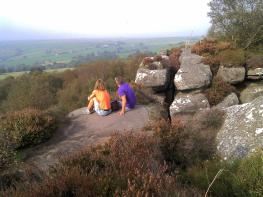
Guisecliff’s stark crags loom above lush woods, while the moors provide vast prospects.
Guisecliff
2.75 miles (4.4kms)
Nidderdale lies outside the Yorkshire Dales National Park but has the status of an Area of Outstanding Natural Beauty (National Landscape). It was recognised as a worthy landscape in the 1950s (when Britain’s first national parks were created) but did not achieve formal designation as an AONB until 1994. One of the landscape features which earned the area such recognition is its ancient woodland, and Guisecliff Wood is one of the best examples. The area round Guisecliff Tarn is shown as consistently wooded on old Ordnance Survey maps from 1854 onward. Today, it’s an enchanting environment of gnarled oak trees and moss-draped boulders.
Not all of the present wood has an unbroken history, as areas were cleared in the past to allow access for quarrying. Parts of Guisecliff Crag itself were quarried on a small scale, and there are several other disused quarries scattered around. There’s little visible evidence of quarrying as you walk through the woods today, but soon after Guisecliff Tarn you join a level track across the hillside. In some places it’s built up on a small embankment, while elsewhere it’s incised into the slope. This track was clearly engineered to take heavy traffic such as laden carts.
After this, the walk makes a steep climb before emerging onto the moor near a radio mast; a much larger quarry lies just to the south. In the 19th century quarrying dominated this landscape. Much of the terraced housing in Pateley Bridge and Glasshouses was built for the quarrymen and their families. Stone was transported to Harrogate via a railway which reached Pateley Bridge in 1862. It closed to passengers in 1951 and to freight in 1964, but the boom years for the quarries were already long gone.
Near the radio mast an alarming sign warns of deep crevasses. If you associate crevasses with glaciers this is perplexing, but there are some deep fissures in the rocks near the edge of the crag and a few further back. It’s possible that these are due to masses of rock shifting bodily. This may have happened when blasting took place nearby during the years of active quarrying.
Although the path runs quite close to the crags, you’re hardly aware of the drop unless you venture out to the edge – but then it’s sudden and absolute. If you have a good head for heights, the edge offers terrific views over Nidderdale.
Walk down the road. There are good verges at first, but take care lower down where the road narrows between walls. On a left-hand bend below the steepest section, turn right on a track opposite a footpath sign.
Follow the track past High Westcliffe and Far High Westcliffe then out through a gate into a field. Go ahead to an old gatepost, and then bear slightly left to follow a track to a gate into woodland.
Follow the track winding through the woods and out into another field. Stay with the track until it bends left again, then turn sharp right along the lower edge of the field to another gate, with a gap-stile alongside, back into the woods.
Follow the path ahead, between holly trees and on through the woods. Another path comes up from the left; keep ahead here, slightly uphill. Ignore another track leading off left and follow the main path as it curves right then forks. Take the right-hand fork towards large boulders; just beyond these you will see Guisecliff Tarn.
Return to the fork and turn right to continue uphill. The path soon swings left and runs fairly level across the slope. Approaching the edge of the woods, the path bears right and soon goes up the hill.
Climb the hill, keeping close to a wall on the left, past a quarry and towards a telecoms mast. Go through a gate left of the mast, ahead a few paces across a track, then turn right along the enclosing fence. A sign here warns of dangerous crevasses, so take great care. Follow the fence round, then turn left alongside a wall. Go over a stile and continue. Before long you will see one of the crevasses on the left. The path continues to be safe enough but sometimes runs close to similar holes which are partly hidden by vegetation, especially in summer.
The wall isn’t continuous but the path is easy to follow. There are a few branches off to the right, which visit the edge of the crags. The views are impressive but the drop is considerable.
Continue until the path alongside the wall reaches moor on the left at a stile. Continue along the path, following the wall then cutting off a corner to a gate near Yorke’s Folly. Pass just right of the folly and follow the path downhill back to the start.
Field, woodland and moorland paths, generally clear, 2 stiles
Lush pastures and rocky woodlands below heather moors with a fringe of crags
Well-behaved dogs can be off the lead in the woods
OS Explorer 298 Nidderdale
Small parking area with information board on sharp bend of Nought Bank Road
Glasshouses and Pateley Bridge
<p>Beware of ‘crevasses’ after Point 6. The walk is safe if you stick to the path, but small children and dogs should not be allowed to stray.</p>
Read our tips to look after yourself and the environment when following this walk.
North Yorkshire, with its two National Parks and two designated Areas of Outstanding Natural Beauty, is England’s largest county and one of the most rural. This is prime walking country, from the heather-clad heights of the North York Moors to the limestone country that is so typical of the Yorkshire Dales – a place of contrasts and discoveries, of history and legend.
The coastline offers its own treasures, from the fishing villages of Staithes and Robin Hood Bay to Scarborough, one time Regency spa and Victorian bathing resort. In the 1890s, the quaint but bustling town of Whitby provided inspiration for Bram Stoker, who set much of his novel, Dracula, in the town. Wizarding enthusiasts head to the village of Goathland, which is the setting for the Hogwarts Express stop at Hogsmeade station in the Harry Potter films.
York is a city of immense historical significance. It was capital of the British province under the Romans in AD 71, a Viking settlement in the 10th century, and in the Middle Ages its prosperity depended on the wool trade. Its city walls date from the 14th century and are among the finest in Europe. However, the gothic Minster, built between 1220 and 1470, is York’s crowning glory.
Discover more than 15,000 professionally rated places to stay, eat and visit from across the UK and Ireland.
Choose a place to stay safe in the knowledge that it has been expertly assessed by trained assessors.
Search by location or the type of place you're visiting to find your next ideal holiday experience.
Read our articles, city guides and recommended things to do for inspiration. We're here to help you explore the UK.