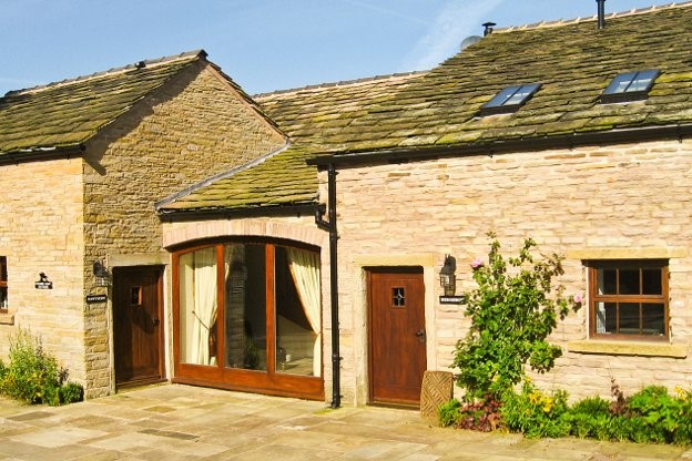

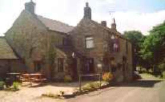

Lowes Mill Cottages at Torr Vale Mill
The four historic cottages are converted outbuildings of the Grade II* listed Torr Vale Mill,…

Lantern Pike’s lofty vantage point looks down on a village now better known for recreation rather than industry.
Hayfield
4 miles (6.4kms)
Hayfield once had cotton mills, papermaking mills and calico printing and dye factories. But it also had times of trouble. Floods washed away three bridges and even swept away some bodies from their churchyard graves. And in 1830 it resounded to marching feet of a thousand protesting mill workers, demanding a living wage. As was often the case in such times, the men were beaten back by soldiers and charged with civil disorder. Their industry went into a slow decline that would last a century, and Hayfield returned to its countryside ways.
The first part of the walk follows the Sett Valley Trail, the trackbed of a railway that once linked Manchester and New Mills with Hayfield. At its peak, the steam trains would have brought thousands of people from Manchester, but since 1970 they, too, have disappeared. Today it’s a pleasant tree-lined route, working its way through the valley between the hills of Lantern Pike and Chinley Churn.
The track, and its former wasteland surroundings, are becoming quite a haven for wildlife. Not long after you set off, on the right, is the entrance to Bluebell Wood Local Nature Reserve. Beneath the ash, sycamore, beech and oak you’ll see wood anemone, bluebells and wild garlic, along with the rhubarb-like butterbur. In the days before fridges, butterbur leaves were used to wrap butter to keep it cool.
The route from Hayfield past Lantern Pike also follows the course of the Pennine Bridleway, a National Trail designed for horse riders and cyclists, as well as walkers, that stretches all the way from the Peak District to Northumberland.
The ascent to Lantern Pike first follows a shady path through woods, then a country lane with wild flowers in the verges, and finally a path on heather and grass slopes to the rocky crested summit. It’s not one of the highest hills around, but the sense of elevation is palpable and the views back to Hayfield and Kinder Scout beyond are impressive. Lantern Pike’s name comes from the beacon tower that once stood on its summit. It had to be demolished in 1907 after falling into a dangerous state of disrepair.
On the return leg you’ll notice waymarkers for ‘Kinder Trespass 75’. This is a 14-mile (22.5km) walking route from New Mills devised to commemorate the 75th anniversary of the Kinder Scout Mass Trespass, when working-class men and women went on to the private grouse moors above Hayfield to demand a right of access. Today Hayfield is busy most weekends with walkers, many heading up on to those same moors, but the Mass Trespass is a reminder that the village’s heritage is rooted in more than just textile mills.
From the car park in Hayfield follow the old railway trackbed signed ‘Sett Valley Trail’. This heads west down the valley and above the River Sett to come out on a road. Turn right and walk along it for 200yds (183m).
Turn right up a cobbled track behind the cottages of the Crescent. Beyond a gate, the track meets a tarred farm lane at a hairpin bend. Follow the higher course to reach a road. Go right, then left beside cottages for a steep surfaced lane further up the hillside. Go straight on at the junction with Higher Cliff Farm (marked as Upper Cliffe Farm on OS maps).
Go through a gate by the National Trust sign for Lantern Pike, and leave the bridleway here. Turn left along a grassy wall-side path climbing heather and bracken slopes to the rock-fringed ridge. Turn right and ascend the airy crest to Lantern Pike’s summit, which is topped by a view indicator.
From here the path continues northwards, descending to a gate at the far boundary of the National Trust estate, where it rejoins the track you left earlier. Follow this northwards across high pastures to a six-way signpost to the west of Blackshaw Farm.
Don’t go through the gate; instead turn hard right, almost back on yourself, for the path signposted ‘Hayfield via Little Hayfield’. Follow the wall on the left across the slope, then down the edge of woodland. Keep going downhill on the main path until you cross a stile by a house.
Ignore the second stile immediately ahead, but instead turn right and walk along the driveway, which is a public footpath, heading gently downhill. At the hairpin go straight on along a bridleway, then fork left for a path down to cottages. Cross the river and beyond the buildings walk out along the road to enter Hayfield.
At the junction at the end turn left and walk along the pavement. Just before the overhead bridge go right, by a notice board about the Calico Trail, and out across an open patch of ground known as the Old School Field. Follow the path to the far left corner.
Go right over the footbridge among the trees, then follow the path along the bank of the River Sett and up between houses. Turn left to return to the car park. The village centre is to the left, across the A624 (pedestrian crossing or underpass).
Good paths and tracks; several stiles
Heather moorland and rolling farm pastures
Mostly good, but lead required in livestock fields beyond Lantern Pike
OS Explorer OL1 Dark Peak
Sett Valley Trail pay car park, Hayfield
At car park
Read our tips to look after yourself and the environment when following this walk.
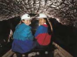
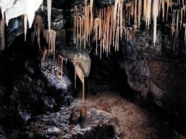
The natural features of this central English county range from the modest heights of the Peak District National Park, where Kinder Scout stands at 2,088 ft (636 m), to the depths of its remarkable underground caverns, floodlit to reveal exquisite Blue John stone. Walkers and cyclists will enjoy the High Peak Trail which extends from the Derwent Valley to the limestone plateau near Buxton, and for many, the spectacular scenery is what draws them to the area.
The county is well endowed with stately homes – most notably Chatsworth, the palatial home of the Duke and Duchess of Devonshire, with its outstanding collections of paintings, statuary and art. Other gems include the well preserved medieval Haddon Hall, the Elizabethan Hardwick Hall, and Kedleston Hall, whose entrance front has been described as the grandest Palladian façade in Britain.
The spa town of Matlock is the county’s administrative centre and other major towns of interest include Derby and the old coal mining town of Chesterfield, with its crooked spire. Around the villages of Derbyshire, look out for the ancient tradition of well dressing, the decorating of springs and wells – the precious sources of life-sustaining water – with pictures formed from flowers.
Discover more than 15,000 professionally rated places to stay, eat and visit from across the UK and Ireland.
Choose a place to stay safe in the knowledge that it has been expertly assessed by trained assessors.
Search by location or the type of place you're visiting to find your next ideal holiday experience.
Read our articles, city guides and recommended things to do for inspiration. We're here to help you explore the UK.