


Sea Gem
Close to the beach in Amble, Sea Gem is a contemporary home with huge glass windows and glass…

Discover this Northumberland town with a long and varied history.
Hexham
4.25 miles (6.8kms)
It was AD 674 and the Romans had been gone over 200 years. Their wall lay crumbling on the green hills to the north, high above the valley of the Tyne. These were the early days of Christianity, when the first monasteries and abbeys were established. Queen Etheldreda of Northumbria gave Bishop Wilfrid land by the river and here, at Hexham, he would build his priory.
Wilfrid had travelled far and wide, including to Rome, and had been impressed by the splendour and majesty of many European churches. His would be a magnificent one with ‘crypts of beautifully finished stone… walls of wonderful height and length’. Many of the stones in his great building were Roman, removed from the fort at Corbridge. The monastery became a cathedral and a renowned centre of learning. However, these were dark days and places like this were rich pickings for Viking raiders. The priory was attacked on many times, but in AD 875 Halfdene the Dane, who had ransacked much of the county, finally burned it down. It wasn’t until 1113, when the Augustinians were awarded the land and started the present abbey, that it was restored to its former majesty.
The abbey buildings survived Henry VIII’s Dissolution of the Monasteries of the 1530s because they were was also used as a parish church. Instead of being demolished, Hexham was embellished and extended. The original crypt was retained intact too, and is now surely one of the finest Saxon structures to be found anywhere in Britain. While the nave and transepts date back to the 12th and 13th centuries, Dobson’s East End and Temple Moore’s nave were constructed between 1850 and 1910.
In the shadow of the abbey, and also constructed with the help of Roman masonry, are the 14th-century Moot Hall and the Manor Office, which was the first purpose-built gaol in Britain. The two buildings will be the first points of interest you’ll see on the walk. Through the arch of the Moot Hall you come to the Market Square, which in 1761 became the scene of a major tragedy. Angry lead miners from Allendale, who were objecting to their conscription to the local militia, descended on Hexham in protest. On this spot they were read the Riot Act. Fighting broke out and, by the end of the day, more than 300 miners were injured and 50 were killed. The North Yorkshire Militia subsequently became known as the Hexham Butchers.
Past Benson’s Monument the walk comes to the edge of the old part of town and side-steps most of the new by climbing the southern hillsides along a wooded dell, known as Cowgarth Dene. The little stream here provided water for the monks of the priory. At Black House you’re at the top of the walk and can see Hexham and the valley that Wilfrid inherited.
Leave the top of the car park (the far end from the supermarket), climbing steps between the tourist information centre and cafe. Carry on along Hallgate past the Old Gaol and bear left beneath the Moot Hall arch into Market Place. Cross to the Abbey and turn left along Beaumont Street, passing between Sele Park and Queen's Hall to a junction overlooked by a statute commemorating the Boer War hero, Colonel Benson.
Cross to the street opposite, turning right at the top. Ignore Elvaston and St Andrew's roads off left and walk beyond the street's end along a tarmac path. Disregarding a junction, follow it down to the foot of Cowgarth Dene.
Take the path ahead into the wooded dene, forking left before a bridge to continue beside Wydon Burn. Over a bridge higher up, carry on along the main path to emerge onto open grass behind housing. Swing left above the wood, shortly meeting the end of a track.
Walk up, joining a street to reach Wydon Water Park. Enter the car park and take a path to the right around the lake. Beyond a bridge, fork right, then double back to re-cross the burn. Leaving onto a narrow lane, go left. At the top, bear left of a drive along a rising path to emerge onto a street.
Climb left to a bend by Intake Farm. Through a kissing gate on the right, follow the bottom field edge to a stile. A woodland path leads away above the upper reaches of Wydon Burn, crossing another stile before ultimately emerging onto a lane. Follow it left steeply uphill past a holiday park to a junction opposite Rising Sun Farm.
Turn left along the lane, known as The Yarridge, keeping ahead at a crossroads past Black House Farm.
Not far beyond the farm, cross a ladder stile on the left. Follow the left hedge down the perimeter of successive fields, finally leaving through a gate near the bottom by a white house onto a lane.
Continue down the hill to a T-junction with the B6306 and go left back into the town. Reaching the main road at the bottom go left and then, crossing at the pedestrian lights, turn off right along St Mary's Chare, which leads back to the market square. Retrace your route under the Moot Hall arch back to the car park.
Town streets, lanes and woodland paths, 4 stiles
Market town and small wooded valleys
Can run free in woods of Cowgarth Dene and Wydon Burn
AA Walker's Map 29 Hadrian's Wall
Pay-and-display car park, next to supermarket
At car park, by tourist information centre
Read our tips to look after yourself and the environment when following this walk.
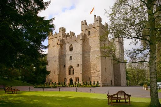
If it’s history you’re after, there’s heaps of it in Northumberland. On Hadrian’s Wall you can imagine scarlet-cloaked Roman legionaries keeping watch for painted Pictish warriors while cursing the English weather and dreaming of home. Desolate battlefield sites and hulking fortresses such as Alnwick, Dunstanburgh, Bamburgh and Warkworth are reminders that this, until not so very long ago, was a contested border region. The ruins of Lindisfarne bear witness to the region’s early Christian history.
Northumberland also has some of Britain’s best beaches. On summer days, and even in winter, you’ll see surfers and other brave souls making the most of the coast. Inland, there are some great walks and bike rides in the dales of the Cheviot Hills and the Simonsides – just hilly enough to be interesting, without being brutally steep. There's dramatic scenery in the High Pennines, where waterfalls plunge into deep valleys, and there are swathes of heather-scented moorland. Northumberland National Park covers over 400 square miles of moorland and valleys with clear streams and pretty, stone-built villages. It’s just the place for wildlife watching too. You’ll find flocks of puffins, guillemots and other seabirds around the Farne Islands, and seals and dolphins offshore.
Discover more than 15,000 professionally rated places to stay, eat and visit from across the UK and Ireland.
Choose a place to stay safe in the knowledge that it has been expertly assessed by trained assessors.
Search by location or the type of place you're visiting to find your next ideal holiday experience.
Read our articles, city guides and recommended things to do for inspiration. We're here to help you explore the UK.


