

YHA The Sill at Hadrian's Wall
YHA The Sill at Hadrian's Wall is a brand-new YHA at The Sill, a landscape discovery centre, in…

Crag Lough
8 miles (12.9kms)
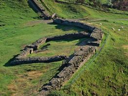
After a visit in AD 122, Roman Emperor Hadrian decided that his Governor of Britain, Nepos, would supervise the building of a great wall to repel the violent Picts and Britons of the North. They originally planned it to span the countryside between the River Irthing at Thirlwall and Newcastle, but added a turf wall that would extend to the west coast at Bowness on Solway.
The engineers were put to work, aided by Roman soldiers from York, Caerleon and Chester. The first-built sections of the castellated wall were 15ft (4.5m) high and 10ft (3m) wide, though later sections were reduced in size in order to speed up the construction. On the northern side the Romans excavated a V-shaped ditch, the Berm, 27ft (8.2m) wide and 9ft (2.7m) deep, except where defending crags made this unnecessary. Fortified gateways, or milecastles, were sited along the length of the wall at 1 Roman mile (1.5km) intervals. They would allow passage for through traffic, and also act as a barracks for eight soldiers. Between the milecastles, at intervals of a third of a Roman mile (498m), were turrets, which served as observation posts. Later large forts such as Great Chesters, Carvoran and Housesteads were built close to the wall, and a second ditch, the Vallum, was dug on the south side to enclose the military area. This was a flat-bottomed trench 20ft (6m) wide and 10ft (3m) deep.
After the Roman withdrawal from Britain the wall fell into decay and its crumbling masonry was used to build churches, farmhouses and field walls. After Bonnie Prince Charlie’s 1745 rebellion Parliament demanded that a military road be built. Unfortunately it used Hadrian’s Wall as its foundations for many miles. It seemed that the wall would disintegrate into oblivion. The fact that modern-day visitors can still view this spectacle is largely due to the efforts of entrepreneur and keen archaeologist, John Clayton (1792–1890). He bought much of the land that contained the wall, and presided over the early digs that unearthed its treasures. It now has its own dedicated long distance footpath.
Go through gates behind the car park and continue beyond the end of a gravel path to the base of a dip. Joining Hadrian's Wall trail, climb left, passing through the wall to continue along Peel Crags. After an intervening dip the path drops steeply once more to Milecastle 39. Rising sharply, the path then dips and climbs yet again before settling along Highshield Crags above Crag Lough. Later, beyond pinewood, the path falls to a gate and crossing track.
Through the gate opposite, the path gains height past Hotbank Farm and over Hotbank Crags before descending to Rapishaw Gap.
Cross a ladder stile on the left and head half right with the Pennine Way towards Leadgate. Beyond a footbridge, the trod rises to a gate and ladder stile. Maintain the diagonal course to another gate and stile. Drop left then bend right across moorland grazing, eventually reaching a kissing gate at Cragend.
Ignoring a crossing track, bypass a redundant stile and drop right then left down a steep bank. At the bottom, curve right on an intermittently indistinct trod, passing occasional waymarks to a ladder stile. Bear right over a footbridge and head up past the corner of a wall to a gate and ladder stile.
Go left on the track towards Greenlee. Pass through the yard at East Stonefolds and continue to West Stonefolds. Walk past the house to a gate and stile on the right beyond a barn. Keep on by the left wall, shortly crossing a stream and passing a small plantation. Over another stile, remain beside the left wall, passing a three-way signpost to reach a stile.
To the left is a bird hide overlooking Greenlee Lough, but the onward route lies ahead. Through a kissing gate at the far end of trees, briefly follow the right-hand fence before swinging out across the marsh along a wooden walkway. Reaching a junction, keep right, heading back to firmer ground. Through a gate, bear half left up a tussock grass moor. The path soon evaporates, but watch for occasional waymarks that guide you to a signpost beside a gravel track.
Follow it left to Gibbs Hill. After 0.75 miles (1.2km), at a junction near the farm, keep right, the track winding over a rise around the farm to another junction. Turn right over a bridge, the ongoing narrow lane leading up the hillside for another mile (1.6km) to meet the main lane. Go left and climb over the shoulder of Hound Hill back to the car park.
Mainly clear paths and tracks, but some faint moorland trods, 16 stiles
Ridge and wild moorland
Farming country, keep dogs on lead; long section of wooden walkway
AA Walker's Map 29 Hadrian's Wall
Steel Rigg pay-and-display car park
Nearby at Twice Brewed and Housesteads information centres
<p>Please don't damage wall by walking on it</p>
Read our tips to look after yourself and the environment when following this walk.
If it’s history you’re after, there’s heaps of it in Northumberland. On Hadrian’s Wall you can imagine scarlet-cloaked Roman legionaries keeping watch for painted Pictish warriors while cursing the English weather and dreaming of home. Desolate battlefield sites and hulking fortresses such as Alnwick, Dunstanburgh, Bamburgh and Warkworth are reminders that this, until not so very long ago, was a contested border region. The ruins of Lindisfarne bear witness to the region’s early Christian history.
Northumberland also has some of Britain’s best beaches. On summer days, and even in winter, you’ll see surfers and other brave souls making the most of the coast. Inland, there are some great walks and bike rides in the dales of the Cheviot Hills and the Simonsides – just hilly enough to be interesting, without being brutally steep. There's dramatic scenery in the High Pennines, where waterfalls plunge into deep valleys, and there are swathes of heather-scented moorland. Northumberland National Park covers over 400 square miles of moorland and valleys with clear streams and pretty, stone-built villages. It’s just the place for wildlife watching too. You’ll find flocks of puffins, guillemots and other seabirds around the Farne Islands, and seals and dolphins offshore.
Discover more than 15,000 professionally rated places to stay, eat and visit from across the UK and Ireland.
Choose a place to stay safe in the knowledge that it has been expertly assessed by trained assessors.
Search by location or the type of place you're visiting to find your next ideal holiday experience.
Read our articles, city guides and recommended things to do for inspiration. We're here to help you explore the UK.