"From Polden’s edge down on to the Somerset Levels and up again"
Walk directions
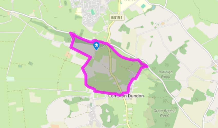
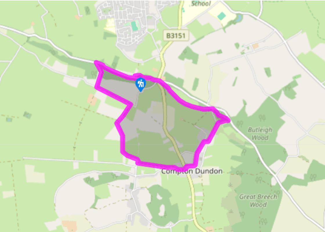
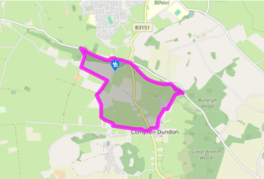
From the parking area on the youth hostel side, cross and turn right on a woodland path. After 100yds (91m) a small, steep path descends on the left with some wooden steps. At the wood's foot turn right, and at a field corner go down a little to reach another track. This runs along the base of the wood to a lane.
Go down to the entrance of Lower Ivy Thorn Farm, and turn left into a track. After 0.5 miles (800m) this reaches the corner of an unsurfaced road, where you turn right. After 0.25 miles (400m) the track turns left into a field. Follow its edge, with a ditch and fence to your left, to a gate at the field corner. In the next field continue alongside the ditch to the corner. Turn left over a fine, high footbridge, then bear right. The field-edge zigzags to pass to the left of Hurst Farm, leading to a tarred lane.
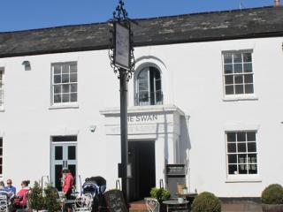
Turn right to reach a rutted track on the left, opposite the farm entrance. Follow this green track until it joins Ham Lane. Follow this lane to reach the crossroads of the B3151 in Compton Dundon, with the Castlebrook Inn to your right.
Cross the busy B3151 and pass between an ancient market cross (right) and a granite Victorian obelisk (left) into Compton Street. At the first junction keep round to the left, towards the Hood Monument above. As the street starts to climb, turn right – signposted ‘Butleigh’ – and left up the lane beyond. Where it reaches woodland bear right, up a steep fenced path, ignoring stiles to left and right. The path slants up into the wood. Then, some 35yds (32m) before it arrives at a road, turn left along the top of the steep ground, to the Hood Monument.
Continue down through the wood to a minor road, with the main road 50yds (46m) away on the right. Ignore a path descending opposite but turn right for a few steps to a footpath sign and a kissing gate. A grass path heads gently up the crest of Collard Hill, with wide views to the left.
From the summit go straight on down to a stile and the signposted crossroads of the B3151. Cross both roads. The ridge road is signposted for the youth hostel, and your path is just to its right. It crosses a glade into woodland. Keep to the right of some hummocky ground to the wood's edge, and follow this path to the car park.
Of Somerset's six hill ranges, the Poldens are the smallest; they rise to just 400ft (122m) at Great Breach Wood. Along the hedged A39 the car driver won't have any feeling of being on a summit ridge. The passengers, however, will be getting glimpses, between the branches, of wide lands on either... side. And if you get out and stand at the top of the southern scarp, the long, windswept edge above the Levels is almost like the top of a sea cliff. In fact, a sea cliff is what it once was. The Bristol Channel has flowed over the Levels several times in the last few millennia – and still does, occasionally, during winter floods. To the north, the village of Burtle stands not on peat but on a sandbank with seashells. Glastonbury Tor and Brent Knoll were formed as islands undercut by the waves. Hardy's tragic poem This high, dry ridge has been a road since Roman times. An inn stood at Marshall's Elm, now the site of the Street Youth Hostel and the start of our walk. An incident here provoked Thomas Hardy (1840-1928) to put pen to paper. A Trampwoman's Tragedy (1902) concerns flirtation and murder, and was turned down by the editor of Cornhill magazine in the United States as 'not a poem he could possibly print in a family periodical'. Despite being set in Somerset, Hardy considered it his most successful poem – and much shorter than any of the Dorset novels. And as the sun drew down to west, We climb the toilsome Polden crest, And saw, of landskip sights the best, The inn that beamed thereby. Beneath us figured tor and lea, From Mendip to the western sea – I doubt if finer sight there be Within this royal realm. Given the Polden status as a former sea cliff, it's quite appropriate that one of England's admirals should stand on Windmill Hill, in the shape of a stone column. Samuel Hood, born 1724, is perhaps England's seventh most famous admiral. He entered the navy as a teenager, and rose to distinguish himself as a bad-tempered but effective commander. American historians seem relieved that, during the Battle of the Capes in Chesapeake Bay in 1781, a bad decision by Admiral Rodney left Hood a bystander while the Royal Navy suffered one of its worst-ever defeats. In the early part of the Napoleonic War, Hood served in the Mediterranean. He mounted a successful raid on Toulon in 1793; a junior officer on the raiding party, one Horatio Nelson, was wounded by flying gravel thrown up by a cannonball and lost the sight in one eye. Hood retired the next year, and died in 1814 after seeing his tactical ideas triumphantly continued by young Nelson.
Somerset remains rural and unspoiled, and ever popular areas to visit are the limestone and red sandstone Mendip Hills rising to over 1,000 feet, and by complete contrast, to the south and southwest, the flat landscape of the Somerset Levels. Another popular spot, the Quantocks, once the haunt of poets Coleridge and Wordsworth, are noted for their gentle slopes, heather-covered moorland expanses and red deer.
"From Polden’s edge down on to the Somerset Levels and up again"
Walk details
2hrs 15min
Difficulty:
Medium
Gradient:
Gentle
Distance:
4.5 miles (7.2kms)
Ascent:
450ft (137m)
Walk directions
From the parking area on the youth hostel side, cross and turn right on a woodland path. After 100yds (91m) a small, steep path descends on the left with some wooden steps. At the wood's foot turn right, and at a field corner go down a little to reach another track. This runs along the base of the wood to a lane.
1 of 6
Go down to the entrance of Lower Ivy Thorn Farm, and turn left into a track. After 0.5 miles (800m) this reaches the corner of an unsurfaced road, where you turn right. After 0.25 miles (400m) the track turns left into a field. Follow its edge, with a ditch and fence to your left, to a gate at the field corner. In the next field continue alongside the ditch to the corner. Turn left over a fine, high footbridge, then bear right. The field-edge zigzags to pass to the left of Hurst Farm, leading to a tarred lane.
2 of 6
Turn right to reach a rutted track on the left, opposite the farm entrance. Follow this green track until it joins Ham Lane. Follow this lane to reach the crossroads of the B3151 in Compton Dundon, with the Castlebrook Inn to your right.
3 of 6
Cross the busy B3151 and pass between an ancient market cross (right) and a granite Victorian obelisk (left) into Compton Street. At the first junction keep round to the left, towards the Hood Monument above. As the street starts to climb, turn right – signposted ‘Butleigh’ – and left up the lane beyond. Where it reaches woodland bear right, up a steep fenced path, ignoring stiles to left and right. The path slants up into the wood. Then, some 35yds (32m) before it arrives at a road, turn left along the top of the steep ground, to the Hood Monument.
4 of 6
Continue down through the wood to a minor road, with the main road 50yds (46m) away on the right. Ignore a path descending opposite but turn right for a few steps to a footpath sign and a kissing gate. A grass path heads gently up the crest of Collard Hill, with wide views to the left.
5 of 6
From the summit go straight on down to a stile and the signposted crossroads of the B3151. Cross both roads. The ridge road is signposted for the youth hostel, and your path is just to its right. It crosses a glade into woodland. Keep to the right of some hummocky ground to the wood's edge, and follow this path to the car park.
Of Somerset's six hill ranges, the Poldens are the smallest; they rise to just 400ft (122m) at Great Breach Wood. Along the hedged A39 the car driver won't have any feeling of being on a summit ridge. The passengers, however, will be getting glimpses, between the branches, of wide lands on either... side. And if you get out and stand at the top of the southern scarp, the long, windswept edge above the Levels is almost like the top of a sea cliff. In fact, a sea cliff is what it once was. The Bristol Channel has flowed over the Levels several times in the last few millennia – and still does, occasionally, during winter floods. To the north, the village of Burtle stands not on peat but on a sandbank with seashells. Glastonbury Tor and Brent Knoll were formed as islands undercut by the waves. Hardy's tragic poem This high, dry ridge has been a road since Roman times. An inn stood at Marshall's Elm, now the site of the Street Youth Hostel and the start of our walk. An incident here provoked Thomas Hardy (1840-1928) to put pen to paper. A Trampwoman's Tragedy (1902) concerns flirtation and murder, and was turned down by the editor of Cornhill magazine in the United States as 'not a poem he could possibly print in a family periodical'. Despite being set in Somerset, Hardy considered it his most successful poem – and much shorter than any of the Dorset novels. And as the sun drew down to west, We climb the toilsome Polden crest, And saw, of landskip sights the best, The inn that beamed thereby. Beneath us figured tor and lea, From Mendip to the western sea – I doubt if finer sight there be Within this royal realm. Given the Polden status as a former sea cliff, it's quite appropriate that one of England's admirals should stand on Windmill Hill, in the shape of a stone column. Samuel Hood, born 1724, is perhaps England's seventh most famous admiral. He entered the navy as a teenager, and rose to distinguish himself as a bad-tempered but effective commander. American historians seem relieved that, during the Battle of the Capes in Chesapeake Bay in 1781, a bad decision by Admiral Rodney left Hood a bystander while the Royal Navy suffered one of its worst-ever defeats. In the early part of the Napoleonic War, Hood served in the Mediterranean. He mounted a successful raid on Toulon in 1793; a junior officer on the raiding party, one Horatio Nelson, was wounded by flying gravel thrown up by a cannonball and lost the sight in one eye. Hood retired the next year, and died in 1814 after seeing his tactical ideas triumphantly continued by young Nelson.
Somerset remains rural and unspoiled, and ever popular areas to visit are the limestone and red sandstone Mendip Hills rising to over 1,000 feet, and by complete contrast, to the south and southwest, the flat landscape of the Somerset Levels. Another popular spot, the Quantocks, once the haunt of poets Coleridge and Wordsworth, are noted for their gentle slopes, heather-covered moorland expanses and red deer.