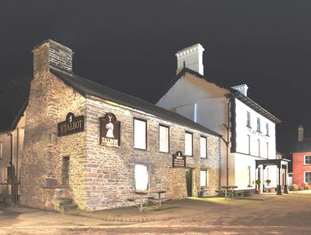
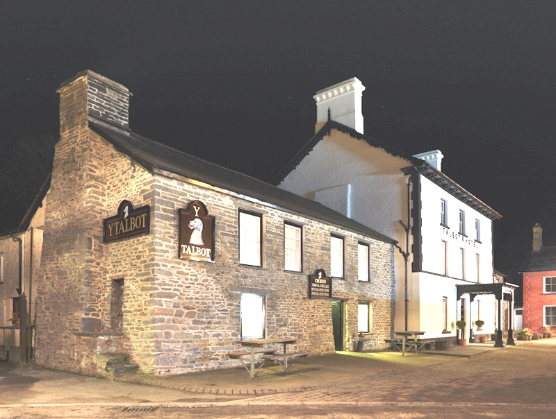
Y Talbot
Located in the heart of this quiet town, Y Talbot has been appointed to provide a range of very…

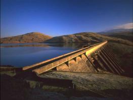
Mining ruins and a deep river gorge in the spectacular valley of Cwm Rheidol
Devil's Bridge
7 miles (11.3kms)
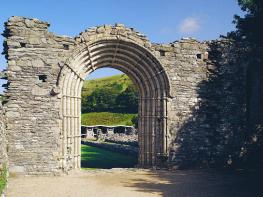
The immediate neighbourhood of Devil’s Bridge contains some of the most spectacular scenery in mid Wales. The village itself is bisected by the Mynach river, a tributary of the Rheidol, which plunges some 300ft (90m) down five great rocky steps into the Rheidol Valley. Crossing the river’s deep, narrow ravine are three bridges (c. 1188, 1753, 1901), unusually built one on top of the other. According to local legend, the oldest of the bridges was built by the Devil himself, though it is more likely to have been built by the monks of Strata Florida. The name of the village in Welsh, Pontarfynach, translates as ‘Bridge on [the] Monk’.
Below Devil’s Bridge, the land falls steeply away into Cwm Rheidol. The valley slopes are clothed in ancient oak woodland and are a designated national nature reserve (Coed Rheidol). The moist, shady conditions provide an ideal environment for mosses, liverworts and lichens, which carpet the steep rocky slopes near the bottom of the gorge. These in turn support a varied ecosystem, with nearly 80 species of birds having been recorded in the woodland. Breeding birds include the redstart, the wood warbler and the pied flycatcher. Otters are known to live in the river, but you’ll be lucky to spot one.
Between Ponterwyd and Devil’s Bridge, the Rheidol is squeezed through a narrow, rocky ravine culminating in the Gyfarllwyd Falls, ‘a valley within a valley’ formed as a result of headward erosion during the last ice age. Unfortunately, the deep gorge is almost entirely inaccessible to walkers, though the crossing of Parson’s Bridge near Ysbyty Cynfyn provides a brief but memorable glimpse of this extraordinary landscape. Lead mining in the valley was an important industry up until the end of the 19th century, and it has left a legacy of serious environmental problems in the Rheidol river. These include elevated levels of zinc, lead, copper, cadmium and other metals, as well as high levels of acidity. Artificial wetlands have been created downstream from Devil’s Bridge to act as a biofilter, removing pollutants and contaminated sediments from the water.
Winding across the wooded slopes between Aberystwyth and Devil’s Bridge is the Vale of Rheidol Railway. This narrow-gauge steam line was opened in 1902, principally to serve the logging and mining industries in the valley. To save money, rock was hand-hewn out of the steep valley slopes rather than blasted. By the time the railway opened, however, the lead-mining industry was in a steep decline, and tourism rapidly became a more important source of income for the railway. The line continues to offer a regular service between May and the end of October each year.
From the car park, return to the main road and turn left. Just past the last house, take a path on the right signed to Borth. This runs above the Vale of Rheidol Railway, then crosses the line and continues down through woodland to a bridge over the Afon Rheidol.
Turn right and follow a lane/track up the valley to a sharp left-hand bend. Keep ahead on to a footpath, then turn steeply uphill to the left and climb through woodland. On emerging in a field, climb again, then join a level grassy track parallel to a wooded valley on the right.
At a metal gate, keep ahead on to a vehicle track as far as Penrhiw farm. Turn right at a footpath sign and cross a field to a footbridge over the Afon Tuen. Climb to a lane and turn right. Pass a farm (Llwyn Teifi Uchaf) and continue on to a level farm track.
Where directed, fork right on to a grassy track and descend gently to a stone ruin. Cross a stile and descend along the right-hand field edge to another stile. Keep ahead to a stile near Dolgamfa farm, then descend to the right along a path between fences. Bear left and follow a woodland path down to Parson’s Bridge.
Cross the Afon Rheidol and climb steeply left. Hairpin right, then, at the next hairpin bend, keep ahead along a rough, narrow path to a stile into a field. Following waymark arrows, cross two fields to reach a footbridge over a stream, then keep ahead through two more fields to a junction with the A4120.
Turn right and follow the road past Erwbarfe farm and caravan park. At the second lay-by on the left, cross the road to a stile and bear right towards the top corner of a field. Cross a stile near a clump of trees and climb left to another. Turn right along a level grassy track towards a field gate.
After a second field gate, leave the track for a waymarked path bearing left. Climb towards trees and follow the woodland boundary to the right. At a gravel track, keep ahead on to a rougher track alongside a fence. Head straight down a field to an enclosed path and descend to the ruins of a mill by the Mynach river.
Cross a bridge and climb steeply to a road. Turn right, then bear left towards a house. Climb steps to a stile and join a sunken track. In an area of Scots pine, turn right at a waymark post and cross a field. Climb a stile in a fence and follow a downhill track back to the car park.
Well-marked field and woodland paths across some steep, rough terrain (19 stiles)
Wooded river valleys and upland pasture
Dogs need to be kept under close control near fast-flowing rivers and fields with sheep
OS Explorer 213 Aberystwyth & Cwm Rheidol
Free car park opposite the terminus for the Vale of Rheidol Railway
At the car park in Devil’s Bridge (open Easter to end of September)
<p>Care needs to be taken where the path is narrow and exposed</p>
Read our tips to look after yourself and the environment when following this walk.
The name ‘Ceredigion’ takes a bit of explanation. The town of Cardigan gives its name to the surrounding bay, but the county now uses the Welsh word for Cardiganshire – Ceredigion, pronounced with a ‘dig’. Cardigan Bay itself is a large inlet of the Irish Sea and stretches from Bardsey Island to Strumble Head. With many beaches and a unique marine life, it’s the place to come to spot bottlenose dolphins, porpoises and Atlantic grey seals. The area is a Special Area of Conservation (SAC), designated under European law to protect its species and habitats. The Ceredigion coastal path is also a major attraction.
Much of the surrounding land is fertile farmland, dotted with towns and seaside resorts such as Fishguard, New Quay, Aberaeron, Aberystwyth, Borth, Aberdyfi, Barmouth and Porthmadog. It’s also a section of coast that major rivers flow into, including the Afon Glaslyn, Teifi, Rheidol, Dyfi, Aeron, Dysynni and Mawddach. Historically, the area supported a strong maritime industry. Cardigan was a major hub, once having more than 300 ships registered in its port, seven times as many as Cardiff. Due to being something of a backwater, in many ways this area remains charmingly unspoilt. The nearby heather-clad Preseli Hills are an additional delight.
Discover more than 15,000 professionally rated places to stay, eat and visit from across the UK and Ireland.
Choose a place to stay safe in the knowledge that it has been expertly assessed by trained assessors.
Search by location or the type of place you're visiting to find your next ideal holiday experience.
Read our articles, city guides and recommended things to do for inspiration. We're here to help you explore the UK.