"See a heritage steam railway in action, walk in delightful Sussex countryside and alongside the winding River Uck."
Walk directions
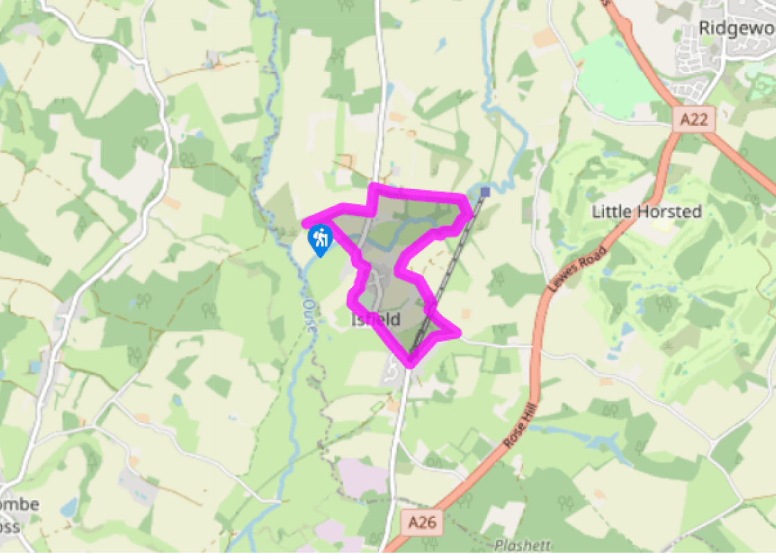
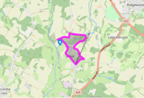
From the church car park walk back along the access lane to pass a pill box.
At the road junction turn left and pass the walled pound. Opposite the gates to Isfield Place, go right over a footbridge and stile and follow the path through the copse, soon bending right and immediately left, to a stile. Over this head half right across pasture to climb a stile in the far corner. Turn right along a grassy track and keep forward along a broad grassy strip where a track joins from a pill box to the right.
Reach the riverbank, go right and through a gate to follow the river bank to a bridge with gates each side. Across this go right along the river bank and through a gate. After passing through a kissing gate turn left along the hedge, away from the river. Follow the field-edge, and follow marker arrows to continue forward along a track as you pass just to the right of the Rowebuck Stud buildings.
Just beyond these buildings, turn left at a footpath post at a field corner, along an enclosed path and over a stile to continue ahead past a garden, then quarter right across a field, through a conifer wood, to the railway.
Bear right alongside the railway, then through a kissing gate, cross the railway bridge with views to Isfield Station. Over a stile continue ahead along the right edge of the field and onto the lane via a stile. Turn right and follow the road to the former level crossing in Isfield.
Turn right to visit the Lavender Line based in Isfield Station and then continue ahead along the village street as far as a bend by the village sign to go left at the bridleway sign. Follow a lane as it curves right. Where it bears left cross a stile and continue along the right edge of the field to a kissing gate. At the village hall field bear quarter left to the road.
Turn left along the road and then left onto a footpath opposite Hope Cottage and just before a 30mph sign. Through a gate continue ahead across sheep pasture, Isfield church ahead. Through a hand gate cross the River Uck on a footbridge, then along the left side of the hedge to go through a bridle gate. Cross another footbridge into a cattle pasture and go half left to a kissing gate by the church.
Terrain
- Field paths, tracks and lanes, several stiles
Landscape
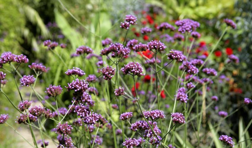
- Gently rolling countryside and the banks of the River Uck
Dog friendliness
- On lead in livestock fields and through village
Parking
- Car park at Isfield church, but not on Sunday mornings during church services; plenty of roadside parking in Isfield village
Toilets en route
- None on route
About the walk
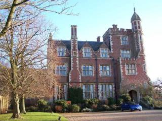
Lavender and locomotives The former Lewes to Uckfield Railway line opened in 1858 and by 1860 had been absorbed into the London, Brighton and South Coast Railway. Supporters successfully fought off Dr Beeching’s closure proposals, but the route was finally closed in 1969. In 1983 the station was... bought, and restoration of the station buildings and the signal box was undertaken, and new railway track laid. There is now a 0.75-mile (1.2km) track running north from the station, and the walk route passes over it, giving a good view of the station. It is owned by the Lavender Line Preservation Society – the name is nothing to do with the scented plant, but was the name of local coal merchants, A E Lavender & Sons, who operated from the station goods yard. Apart from visiting and being hauled by steam or diesel, you can enrol here for driver training courses. The Cinders Buffet at the station is popular, and the railway runs Wine and Dine Trains where you eat on the move. There is also a model railway in Lavender & Sons old coal office, and a coach with displays and old photographs of the line in its heyday. Always fascinating, this is a well run heritage railway. For timetables visit their website (www.lavender-line.co.uk). A remote church St Margaret of Antioch’s Church is stranded out in the fields near Isfield Place, while the village centre has migrated to the railway line. The church has a Norman tower, and in the chapel are a collection of superb monuments to the Shurley Family of Isfield Place. One Sir John, who died in 1527, is described as ‘chef clerke of the kechen to our souayn kyng henry ye viii’, that is cofferer or keeper of the kitchen budget to Henry VIII. To the west of the church, amid trees, are the earthworks of a Norman motte-and-bailey castle overlooking the River Ouse. Sheep may safely stray Near Isfield Place on the roadside is a square brick enclosure with stone coped walls and quoins, restored in 1990. This was the village pound, used to pen stray cattle and sheep, the owners paying a fine to retrieve their livestock. The date is given as 19th century but it seems to have used 17th- and 18th-century brick and stone, possibly from demolished walls at Isfield Place.
"See a heritage steam railway in action, walk in delightful Sussex countryside and alongside the winding River Uck."
Walk details
1hr 30min
Difficulty:
Easy
Gradient:
Gentle
Distance:
3.25 miles (5.2kms)
Ascent:
33ft (10m)
Walk directions
From the church car park walk back along the access lane to pass a pill box.
1 of 7
At the road junction turn left and pass the walled pound. Opposite the gates to Isfield Place, go right over a footbridge and stile and follow the path through the copse, soon bending right and immediately left, to a stile. Over this head half right across pasture to climb a stile in the far corner. Turn right along a grassy track and keep forward along a broad grassy strip where a track joins from a pill box to the right.
2 of 7
Reach the riverbank, go right and through a gate to follow the river bank to a bridge with gates each side. Across this go right along the river bank and through a gate. After passing through a kissing gate turn left along the hedge, away from the river. Follow the field-edge, and follow marker arrows to continue forward along a track as you pass just to the right of the Rowebuck Stud buildings.
3 of 7
Just beyond these buildings, turn left at a footpath post at a field corner, along an enclosed path and over a stile to continue ahead past a garden, then quarter right across a field, through a conifer wood, to the railway.
4 of 7
Bear right alongside the railway, then through a kissing gate, cross the railway bridge with views to Isfield Station. Over a stile continue ahead along the right edge of the field and onto the lane via a stile. Turn right and follow the road to the former level crossing in Isfield.
5 of 7
Turn right to visit the Lavender Line based in Isfield Station and then continue ahead along the village street as far as a bend by the village sign to go left at the bridleway sign. Follow a lane as it curves right. Where it bears left cross a stile and continue along the right edge of the field to a kissing gate. At the village hall field bear quarter left to the road.
6 of 7
Turn left along the road and then left onto a footpath opposite Hope Cottage and just before a 30mph sign. Through a gate continue ahead across sheep pasture, Isfield church ahead. Through a hand gate cross the River Uck on a footbridge, then along the left side of the hedge to go through a bridle gate. Cross another footbridge into a cattle pasture and go half left to a kissing gate by the church.
Terrain
- Field paths, tracks and lanes, several stiles
Landscape
- Gently rolling countryside and the banks of the River Uck
Dog friendliness
- On lead in livestock fields and through village
Parking
- Car park at Isfield church, but not on Sunday mornings during church services; plenty of roadside parking in Isfield village
Toilets en route
- None on route
About the walk
Lavender and locomotives The former Lewes to Uckfield Railway line opened in 1858 and by 1860 had been absorbed into the London, Brighton and South Coast Railway. Supporters successfully fought off Dr Beeching’s closure proposals, but the route was finally closed in 1969. In 1983 the station was... bought, and restoration of the station buildings and the signal box was undertaken, and new railway track laid. There is now a 0.75-mile (1.2km) track running north from the station, and the walk route passes over it, giving a good view of the station. It is owned by the Lavender Line Preservation Society – the name is nothing to do with the scented plant, but was the name of local coal merchants, A E Lavender & Sons, who operated from the station goods yard. Apart from visiting and being hauled by steam or diesel, you can enrol here for driver training courses. The Cinders Buffet at the station is popular, and the railway runs Wine and Dine Trains where you eat on the move. There is also a model railway in Lavender & Sons old coal office, and a coach with displays and old photographs of the line in its heyday. Always fascinating, this is a well run heritage railway. For timetables visit their website (www.lavender-line.co.uk). A remote church St Margaret of Antioch’s Church is stranded out in the fields near Isfield Place, while the village centre has migrated to the railway line. The church has a Norman tower, and in the chapel are a collection of superb monuments to the Shurley Family of Isfield Place. One Sir John, who died in 1527, is described as ‘chef clerke of the kechen to our souayn kyng henry ye viii’, that is cofferer or keeper of the kitchen budget to Henry VIII. To the west of the church, amid trees, are the earthworks of a Norman motte-and-bailey castle overlooking the River Ouse. Sheep may safely stray Near Isfield Place on the roadside is a square brick enclosure with stone coped walls and quoins, restored in 1990. This was the village pound, used to pen stray cattle and sheep, the owners paying a fine to retrieve their livestock. The date is given as 19th century but it seems to have used 17th- and 18th-century brick and stone, possibly from demolished walls at Isfield Place.