Isle of Wight Coastal Path: Freshwater to Blackgang Chine
Recommended by
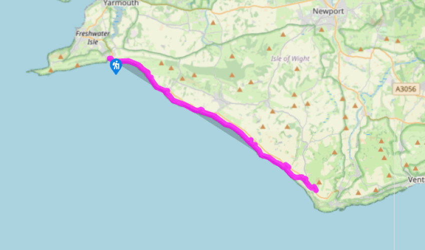
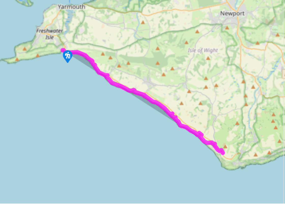
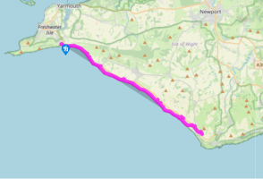
Walk directions
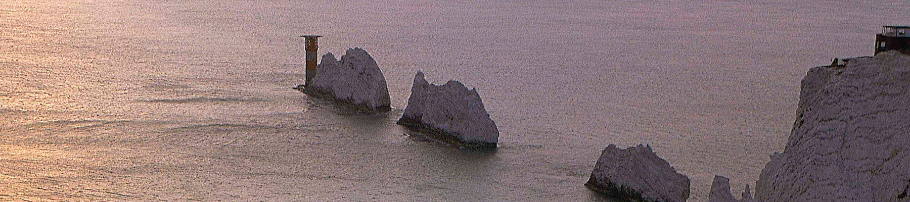
Cross the road with care to reach the beach. Turn left past the independent lifeboat shop and climb the wooden steps to the cliff top. At the stone obelisk memorial to ELM (Edward Lewis Miller from Goudhurst in Kent, who fell to his death here in 1846) on Afton Down, pause to look back at The Needles and Tennyson Down. From here to Compton Chine the path runs very close to the A3055. The cliffs along this most exposed southeasterly section suffer constant erosion from the winter gales, which is why the footpath has in places been pushed inland. Follow the coastal path sign over the stile and down steep steps to take you away from the road.
Pass through the small car park at Shippards Chine, and around the fossil forest at Hanover Point. Brook Chine is the first chine necessitating a detour in front of a row of cottages on Brook Green to get past it. (Alternately, divert left into Brook village before returning to the coastal path.)
Chilton Chine is next, also requiring a detour through the small car park and along the Military Road for 220yds (200m) before rejoining the coast. The path continues to Brighstone Holiday Centre, where, due to coastal erosion, the walk takes you through the 1930s-built holiday chalets with brightly painted doors, and over concrete paths before rejoining the coastline.
Grange Chine offers a choice: either descend within, past holiday chalets and up a steep set of broken steps cut into the hillside, or walk to the road once again. Grange is the halfway point of this stage, and the pleasant village of Brighstone is just 0.5 miles (800m) inland, offering refreshments.
Taking short detours inland, negotiate Cowleaze Chine and Shepherd’s Chine (which has impressive cliffs, pock-marked where glacial boulders have been exposed and dropped into the chine below). Rejoin the coastal path about 150m beyond the car park, and continue to Atherfield Point, not a popular spot with mariners – hundreds of ships met their doom on the reef here. The cottages just inland are coastguards’ cottages. Take a look over the edge at the lobster and fishing boats pulled some way up the cliff-face; not an easy way to make a living.
The next chine to be encountered is Whale Chine, a classic and completely impassable fissure leaving absolutely no option but to head inland to the Military Road once again. Soon after this comes another: Walpen Chine. Just before this on your left, notice the unusual square brick building with the tall doorway, standing alone in the middle of a field. The building was erected during World War II to protect markers counting aerial gunnery practice hits on targets placed on either side of the shelter. It was originally shrouded in wooden shutters and sand banking. Aircraft would approach from landward and fire practice rounds towards the sea. Follow the cliff top path, turning inland towards a row of stone cottages. Pass through the gate on the cliff top, and turn left up the narrow metalled road past the fronts of the cottages.
At the top of this road, turn sharp right up the signed bridleway. This path climbs past the backs of houses to the main road towards Blackgang Chine. Where the path emerges on to the road (A3055), turn right along the road, walking past the entrance turn to the theme park along the wide grassy verge for 100m to reach a stile in the hedge. Cross this and follow the edge of the field to another stile. Now climb the steep path to the Blackgang Viewpoint car park (free).
The route follows the Coastal Path (69 miles/111km), which is well signed on the ground with blue signs and a seagull symbol. Constant erosion of the island’s coastline means the path may be rerouted at any point, but this is usually clearly marked. Note that access for dogs to most of the island’s... beaches is restricted in summer. For information about bus links and timetables, see www.islandbuses.info This section of the route is virtually uninterrupted clifftop path, wide and very pleasant throughout, with minimal human habitation. The path is clear and simple to follow, and is never more than 0.25 miles (400m) away from the main coast road, which is regularly patrolled by buses. The main road (A3055) between Freshwater and Chale is known as the Military Road because the route was privately owned and served purely military purposes for around 70 years, until it was opened to the public in 1933. Its location makes it vulnerable to coastal erosion, and its future is not secure. As you walk along, notice the colour change in the cliffs where the road diverges from the coast. The chalk is replaced by a darker rock, another sedimentary product known as Wealden marl, rich in paleontological artefacts. This coast is continually slumping due to the grey slipper clay. The rain permeates the topsoil and when it gets to the clay, it all slips out into the sea. There is little along this stretch to distract you from the basic pleasures of walking beside the sea. The only thing to upset the continuity of the coastline is the occasional ‘chine’, originating from the Saxon cinan, meaning yawn or gap. Chines are deep ravines that cut into the cliff-edge, often extending some way inland. Many are completely impassable, and require a lengthy hike inland to skirt around them. Blackgang got its name from a ruthless gang of smugglers, and is still an impressive deep and dark gash in the cliff-side. Brook is a hamlet with a history. Brook Hill House, visible on the hillside above, was owned by Charles Seely, a wealthy Nottinghamshire coalmine owner, who made considerable improvements to it. Seely gave the island a lifeboat and libraries – and the Military Road. The house was later lived in by the Bradford-born writer J B Priestley.
Small and intimate – at just 23 miles by 13 miles, the Isle of Wight is a popular holiday destination; with its mild climate, long hours of sunshine and colourful architecture, it has something of a continental flavour. Visitors can walk along the island’s varied coastline using the well-established Coast Path or step back in time to explore the island’s history at some of the forts and castles.
Isle of Wight Coastal Path: Freshwater to Blackgang Chine
Recommended by
Walk details
5hrs
Difficulty:
Medium
Gradient:
Moderate
Distance:
13 miles (21kms)
Ascent:
705ft (215m)
Walk directions
Cross the road with care to reach the beach. Turn left past the independent lifeboat shop and climb the wooden steps to the cliff top. At the stone obelisk memorial to ELM (Edward Lewis Miller from Goudhurst in Kent, who fell to his death here in 1846) on Afton Down, pause to look back at The Needles and Tennyson Down. From here to Compton Chine the path runs very close to the A3055. The cliffs along this most exposed southeasterly section suffer constant erosion from the winter gales, which is why the footpath has in places been pushed inland. Follow the coastal path sign over the stile and down steep steps to take you away from the road.
1 of 7
Pass through the small car park at Shippards Chine, and around the fossil forest at Hanover Point. Brook Chine is the first chine necessitating a detour in front of a row of cottages on Brook Green to get past it. (Alternately, divert left into Brook village before returning to the coastal path.)
2 of 7
Chilton Chine is next, also requiring a detour through the small car park and along the Military Road for 220yds (200m) before rejoining the coast. The path continues to Brighstone Holiday Centre, where, due to coastal erosion, the walk takes you through the 1930s-built holiday chalets with brightly painted doors, and over concrete paths before rejoining the coastline.
3 of 7
Grange Chine offers a choice: either descend within, past holiday chalets and up a steep set of broken steps cut into the hillside, or walk to the road once again. Grange is the halfway point of this stage, and the pleasant village of Brighstone is just 0.5 miles (800m) inland, offering refreshments.
4 of 7
Taking short detours inland, negotiate Cowleaze Chine and Shepherd’s Chine (which has impressive cliffs, pock-marked where glacial boulders have been exposed and dropped into the chine below). Rejoin the coastal path about 150m beyond the car park, and continue to Atherfield Point, not a popular spot with mariners – hundreds of ships met their doom on the reef here. The cottages just inland are coastguards’ cottages. Take a look over the edge at the lobster and fishing boats pulled some way up the cliff-face; not an easy way to make a living.
5 of 7
The next chine to be encountered is Whale Chine, a classic and completely impassable fissure leaving absolutely no option but to head inland to the Military Road once again. Soon after this comes another: Walpen Chine. Just before this on your left, notice the unusual square brick building with the tall doorway, standing alone in the middle of a field. The building was erected during World War II to protect markers counting aerial gunnery practice hits on targets placed on either side of the shelter. It was originally shrouded in wooden shutters and sand banking. Aircraft would approach from landward and fire practice rounds towards the sea. Follow the cliff top path, turning inland towards a row of stone cottages. Pass through the gate on the cliff top, and turn left up the narrow metalled road past the fronts of the cottages.
6 of 7
At the top of this road, turn sharp right up the signed bridleway. This path climbs past the backs of houses to the main road towards Blackgang Chine. Where the path emerges on to the road (A3055), turn right along the road, walking past the entrance turn to the theme park along the wide grassy verge for 100m to reach a stile in the hedge. Cross this and follow the edge of the field to another stile. Now climb the steep path to the Blackgang Viewpoint car park (free).
The route follows the Coastal Path (69 miles/111km), which is well signed on the ground with blue signs and a seagull symbol. Constant erosion of the island’s coastline means the path may be rerouted at any point, but this is usually clearly marked. Note that access for dogs to most of the island’s... beaches is restricted in summer. For information about bus links and timetables, see www.islandbuses.info This section of the route is virtually uninterrupted clifftop path, wide and very pleasant throughout, with minimal human habitation. The path is clear and simple to follow, and is never more than 0.25 miles (400m) away from the main coast road, which is regularly patrolled by buses. The main road (A3055) between Freshwater and Chale is known as the Military Road because the route was privately owned and served purely military purposes for around 70 years, until it was opened to the public in 1933. Its location makes it vulnerable to coastal erosion, and its future is not secure. As you walk along, notice the colour change in the cliffs where the road diverges from the coast. The chalk is replaced by a darker rock, another sedimentary product known as Wealden marl, rich in paleontological artefacts. This coast is continually slumping due to the grey slipper clay. The rain permeates the topsoil and when it gets to the clay, it all slips out into the sea. There is little along this stretch to distract you from the basic pleasures of walking beside the sea. The only thing to upset the continuity of the coastline is the occasional ‘chine’, originating from the Saxon cinan, meaning yawn or gap. Chines are deep ravines that cut into the cliff-edge, often extending some way inland. Many are completely impassable, and require a lengthy hike inland to skirt around them. Blackgang got its name from a ruthless gang of smugglers, and is still an impressive deep and dark gash in the cliff-side. Brook is a hamlet with a history. Brook Hill House, visible on the hillside above, was owned by Charles Seely, a wealthy Nottinghamshire coalmine owner, who made considerable improvements to it. Seely gave the island a lifeboat and libraries – and the Military Road. The house was later lived in by the Bradford-born writer J B Priestley.
Small and intimate – at just 23 miles by 13 miles, the Isle of Wight is a popular holiday destination; with its mild climate, long hours of sunshine and colourful architecture, it has something of a continental flavour. Visitors can walk along the island’s varied coastline using the well-established Coast Path or step back in time to explore the island’s history at some of the forts and castles.