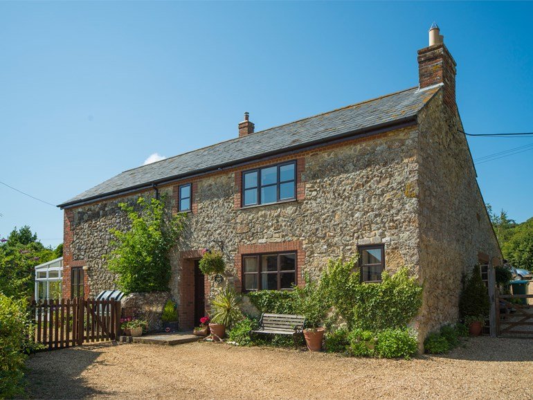
The Orchards Holiday Caravan Park
A really excellent, well-managed park set in a peaceful village location amid downs and…

Shalfleet, IoW
7.5 miles (12kms)
The route follows the Coastal Path (69 miles/111km), which is well signed on the ground with blue signs and a seagull symbol. Constant erosion of the island’s coastline means the path may be rerouted at any point, but this is usually clearly marked. Note that access for dogs to most of the island’s beaches is restricted in summer. For information about bus links and timetables, see www.islandbuses.info
The church at Shalfleet is well worth a look – the sturdy tower was constructed just a few years after the Norman Conquest and, ironically, was often used as a place of refuge from French harassment in the following centuries. There’s a delightful medieval carving depicting a man with two happy animals over the entrance door. Inside it’s refreshingly unaltered, with massive roof beams, wooden box pews, a Jacobean pulpit and beautifully carved linenfold panelling behind the altar.
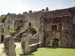
Yarmouth is one of the prettier towns on the island and has its fair share of history, earning its charter in 1332. The castle (English Heritage) was one of a number commissioned by Henry VIII to keep the French at bay, and is worth a visit – you get a good view of it from the Lymington ferry. For a small fee you can stroll on the long wooden pier, built in the 1870s and splendidly restored in the 1980s. You’ll pass attractive grand houses dating to the 18th and 19th century along the High Street, and can contrast these with the little fishermen’s cottages in the back streets. In the church, look out for the overblown memorial to Sir Robert Holmes, local dignitary, buccaneer and friend of Charles II – the statue of him originally depicted Louis XIV of France, but was captured, along with its sculptor, amid the treasures of a piratical raid, and Holmes had the artist model his own head in place of the king’s.
Turn right out of the car park and walk south to the end of the road and the hamlet of Shalfleet. Turn right at the end, by The New Inn, to pass the Church of St Michael the Archangel on the opposite side of the road. Now walk along the verge – much care is needed, as it can be busy. Follow this about 0.5 miles, past Shalfleet House. Where the road begins to dip down, turn right over a stile in the hedge.
Walk straight ahead along the edge of the field, with the hedge on your right. Follow at the bottom as the route swings left, then bear right over a footbridge across a stream. Turn right and follow the muddy path beside the stream, up steps, and fork left to meet a broad track. Turn right here, across the river, and continue ahead up a gentle slope into woodland. Keep ahead at the track crossing, then descend slightly, signed ‘Hamstead Trail’. Pass a barn on your right, and take the next track right, signed ‘Coastal Footpath, Yarmouth 5.5’. The track rises to give good views to the interior of the island. Descend gradually, passing Creek Farm. Pass a house overlooking Newtown River and continue ahead past a gate and down to a wooden jetty on the shore.
Take the footpath on the left just before the shore, first beside a fence and then along the water (may be very muddy) as it skirts a large tributary stream. Follow the path round on duckboards through the marshes, then follow the waymarker left along the edge of a field. Before the next inlet, turn left to cross a stile, and bear diagonally right across the field. Cross a stile in the corner and cross a long raised duckboard bridge. Continue on the path, and descend steps to the coastal shore at Hamstead Point. The concrete ramp and debris here all date back to the intense activities of World War II training, defence and D-Day preparations.
Turn left along the shingle storm beach. Continue on the grass behind, passing a Celtic cross memorial to three young men who drowned in two separate incidents, in 1932 and 1934. Stay on this track which leads up behind trees, along a fence beside pastures. Eventually this brings you out behind farm buildings. Keep ahead up a gravel drive, and where this swings left, walk ahead past a gate, signed ‘Yarmouth 2.75’. Cross a stile by a gate and walk ahead along the field, with the hedge to your left. Squeeze past another gate, cross a field to another stile and then bear left. Where the path forks, bear right, to cross a driveway. Cross a stile by a paddock, go through a gate and walk ahead beside a driveway, beside a modern house. At the gravel lane (Sea View Road) turn left, and keep ahead onto tarmac. Turn right down gravelled West Close, pasing well spaced houses.
At the end turn left into woodland, on a muddy path. At the Bouldnor Forest sign bear right onto a path that can be very muddy and rutted. Where the track swings left keep ahead, following the yellow waymarker. Pass a pair of boundary stones, which mark the edge of land controlled by the War Department during World War II. Continue through a cleared area of heath and gorse, with views to the headland beyond Yarmouth. Continue ahead and down, past the concrete structures of ruined Bouldnor Battery, dating from the 1930s. Enter woodland again and bear left along a duckboard. Bear right briefly to touch the shore, then follow the path left, above the eroded shoreline. At a junction of paths keep ahead. Reach a junction in front of a thatched house and turn left. Keep right at a gravel road. Walk up to meet the main road (A3054).
Cross over with care, to follow the verge through the hamlet of Bouldnor and ahead into Yarmouth. Pass the Boulnor View car park, right. (To walk along the sea wall, as an alternative, descend steps, right, opposite the Thorley Turning, and follow the path along the front.) Where the road forks, keep right, to pass a toilet block and enter the town via the High Street. Continue ahead into Yarmouth town centre – this road leads past interesting old houses and straight to the main square. (There’s a large pay-and-display car park on the southwestern edge of the town.)
Busy roadside verge, field paths, muddy woodland tracks, pavements; many stiles
Fields and woodland, open heath, village and town streets
Lead required along road and around town streets
OS Explorer OL29
Yarmouth seafront and town centre
Read our tips to look after yourself and the environment when following this walk.
There’s a timeless quality to the Isle of Wight. For many it embodies the spirit and atmosphere of English seaside holidays. Small and intimate – at just 23 miles by 13 miles – it’s a great place to get away from it all. And with its mild climate, long hours of sunshine and colourful architecture, it has something of a continental flavour.
Explore the island’s varied coastline at any time of the year using the well-established Coast Path. Even in the depths of winter, the weather conditions are often favourable for walking. The island has more than 500 miles of public rights of way in all. There are numerous other things to do too. You could plan a week’s itinerary and not set foot on the beach. The island’s history is fascinating and it was long considered as a convenient stepping stone for the French in their plan to invade the UK mainland. Various fortifications – including Fort Victoria, Carisbrooke Castle and Yarmouth Castle – reflect its key strategic role in the defence of our coastline.
Discover more than 15,000 professionally rated places to stay, eat and visit from across the UK and Ireland.
Choose a place to stay safe in the knowledge that it has been expertly assessed by trained assessors.
Search by location or the type of place you're visiting to find your next ideal holiday experience.
Read our articles, city guides and recommended things to do for inspiration. We're here to help you explore the UK.