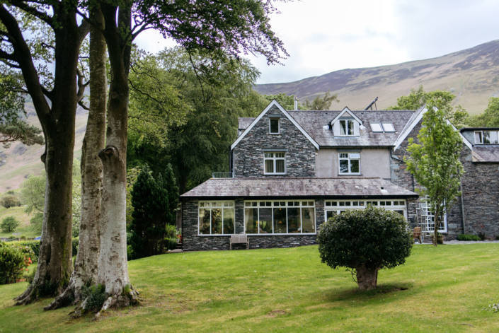
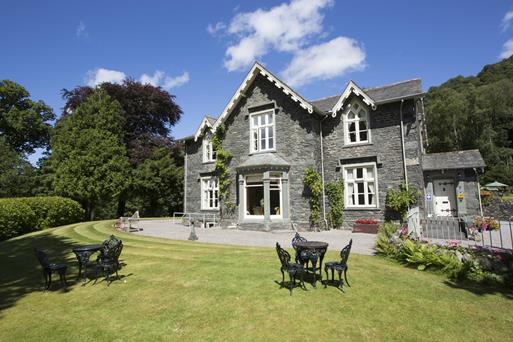


Brackenrigg
A seven-acre country estate, a few miles from Keswick and a short drive to Grasmere, with three…

4.1 miles (6.6kms)
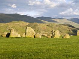
The stone circle at Castlerigg has been attracting tourists since the 17th century and featured in all the guidebooks that began to make the Lake District a destination from the 18th century onwards. There are 38 stones in a not-quite-round circle, and 10 more in a little grove to one side. Some have suggested there is a relationship between this apparently secondary arrangement and the tumulus on the summit of Great Mell Fell, several miles to the east. One can draw an alignment of a solstice sunrise, apparently, though this may be coincidental. What is known about the circle is scant. It dates from the late-neolithic/early Bronze Age, perhaps 3000–2500 bc and its one of a trio in the county that suggest there was a culture here of some sophistication. The other two – Long Meg and her Daughters near Langwathby and Swinside near Duddon Bridge – share Castlerigg’s sense of majestic isolation, but beyond that there seems a great deal of conjecture. There hasn’t even been a great deal of active archaeological investigation, though the National Trust did step in to ‘rescue’ Castlerigg as early as 1913 when there was a suggestion the stones could be fenced off and people charged for the privilege of walking among them. As recently as 2003 an axe, dated to around 3000 bc, from the Langdale ‘factory’, was recovered from a nearby field, so perhaps the people who produced this were associated in some to way to the monument builders.
No amount of speculation detracts from the grandeur of the place. The poet John Keats was clearly so impressed on his visit to the ‘Druid Stones’ in 1818 that it made up for a late dinner: ‘We had to fag up the hill rather too close to dinner time, which was rendered void by the gratification of seeing those aged stones on a gentle rise in the midst of the mountains’, he wrote to his brother the next day.
Opposite the church, climb a stile and follow the grassy path straight ahead. Keep right at a faint fork to climb a stile in a wall. The path continues through a grassy gap. Tewet Tarn comes into view ahead and the Castlerigg stone circle can be seen to the left beyond a white building in the distance. A broad grassy swathe leads down a gently sloping boggy area of open ground.
A gate leads you through a fence and, with Blencathra straight ahead, an obvious path continues to the right of the tarn and another gate. The path heads towards rock outcrops, where you turn right. Bear right beside a wall to pick up a faint track that swings downhill into a narrow enclosure. Drop to a gate in the bottom right-hand corner. Turn left along the road and left again at a T-junction. At the next junction, turn left with the signs to the stone circle and climbing wall. Just after Naddle Bridge, go through the farm gate on the left.
Always aiming for the white buildings of Goosewell Farm to the west, the right of way heads steadily uphill through a series of gates across the fields. Turn left along the road, passing the former farm buildings and climbing wall. As the road bends around to the right by a wood, look for a sign on the left to High Nest and the A591. Don’t follow it now; you’ll come back here shortly.
Continue along the road to the Castlerigg stone circle, accessed through a gate into the field on your left. Afterwards, return to the road and turn right, descending to the path sign passed earlier. Go through the gate and follow a faint path across three fields and to the right of a fenced woodland. When the trees end, continue beside the fence and then the wall to the farmhouse at High Nest. Follow the access road to a cattle grid. Here take the left turn signed towards the A591 and St John’s in the Vale. Approaching the main road, you pass through a gate to a cattle grid on the access road to Low Nest. Turn right and emerge on the verge of the busy A591.
Turn left along the verge for a few paces to another footpath sign on the left. Go through the gate and descend the field towards an access road. Turn left along the road for a short distance then branch off right on a parallel path. Cross the road and keep ahead. Keep left, following the field boundary. At the bottom, go through the gate, carrying on along a muddy farm track for 120yds (110m) to a footpath sign just over a little bridge. Turn left across the field to a bridge over Naddle Beck. On the far side continue through a gate then across a field, heading for a kissing gate where a fence meets a short section of wall. Make your way up the craggy bank, bearing slightly left up the hill. Another kissing gate leads out onto a farm track.
Almost immediately, turn left up the Old Coach Road, following it all the way to the gate by the youth centre and the start.
Grassy paths and tracks, a little road walking, 3 stiles
Fell, fields and open valley
Fields grazed by sheep so dogs should be under control throughout
OS Explorer OL4 The English Lakes (NW)
Responsibly around St John's in the Vale Church and the Diocesan Youth Centre. Don't block the turning circle and note there is no onward road beyond here, whatever SatNav might say!
None on route, nearest in Keswick (3 miles/4.8km)
Read our tips to look after yourself and the environment when following this walk.
Cumbria's rugged yet beautiful landscape is best known for the Lake District National Park that sits within its boundaries. It’s famous for Lake Windermere, England’s largest lake, and Derwent Water, ‘Queen of the English Lakes'. This beautiful countryside once inspired William Wordsworth and his home, Dove Cottage, in Grasmere is a popular museum. Another place of literary pilgrimage is Hill Top, home of Beatrix Potter, located near Windermere. Tom Kitten, Samuel Whiskers and Jemima Puddleduck were all created here.
Much of Cumbria is often overlooked in favour of the Lake Distirct. In the south, the Lune Valley remains as lovely as it was when Turner painted it. The coast is also a secret gem. With its wide cobbled streets, spacious green and views of the Solway Firth, Silloth is a fine Victorian seaside resort. Other towns along this coastline include Whitehaven, Workington and Maryport. Carlisle is well worth a look – once a Roman camp, its red-brick cathedral dates back to the early 12th century and its 11th-century castle was built by William Rufus.
Discover more than 15,000 professionally rated places to stay, eat and visit from across the UK and Ireland.
Choose a place to stay safe in the knowledge that it has been expertly assessed by trained assessors.
Search by location or the type of place you're visiting to find your next ideal holiday experience.
Read our articles, city guides and recommended things to do for inspiration. We're here to help you explore the UK.