
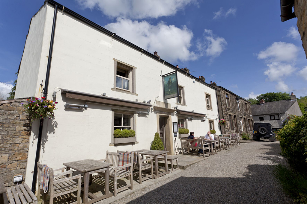


The Inn at Whitewell
Imperious old coaching inn lost in deep country with a river to fish, five-mile views, delicious…

A tough walk that gives a chance to taste the freedom of the high moors
Dunsop Bridge
10.25 miles (16.5kms)
In 1992, BT installed their 100,000th call box in Dunsop Bridge, incorporating an engraved panel that commemorates its position as being in the village nearest to the gravitational centre of Britain. The actual point lies some 4 miles (6.4km) to the north near Whitendale Hanging Stones in the middle of a peat wilderness, but is rarely visited by even the most seasoned walkers. Nevertheless, Dunsop Bridge is surrounded by truly magnificent scenery and is the starting point for many great walks. This route incorporates something that is quite a rarity in Bowland, a public footpath that runs across the tops.
To reach it you cross a stretch of upland pasture. This gives straightforward walking, rarely steep, except where it dips into Oxenhurst Clough. The clough frames a view of the small conical hill called Knot or Sugar Loaf, which began as a coral reef around 250 million years ago. The ascent to the plateau is by a well-defined ridge, giving wider views than from the level top. The prospect takes in the Hodder Valley, Stocks Reservoir and Gisburn Forest, the broader sweep of Ribblesdale and the Yorkshire hills.
The hen harrier teeters on the brink of extinction as a breeding bird in England, its moorland habitat often compromised by management for grouse shooting and the bird itself illegally persecuted by some gamekeepers. However, the United Utilities estate in Bowland, where the landowners have worked with the RSPB for over 30 years, remains one of the rare places in England where one or two pairs usually manage to nest and produce young each year. This magnificent bird is slightly smaller than a buzzard, and the male's acrobatic courtship display, described as 'sky-dancing', is a breathtaking sight that once seen, will never be forgotten. Hen harriers feed upon voles and small birds including red grouse chicks, which unfortunately brings them into conflict with gamekeepers who rear the grouse on the moor for shooting. However, studies have shown that harriers make a negligible impact upon numbers where the grouse population is healthy.
The moorland crossing may seem all too brief before the descent into Whitendale. Here there are reminders that Bowland is a significant water catchment. Although there's only one large reservoir (Stocks), water is extracted from many of the streams and rivers. The track which you join near Whitendale Farm is actually the line of a water pipe: BCWW stands for Blackburn Corporation Water Works. The main waterworks intake is a little further down the valley and from there you follow the access road most of the way back to Dunsop Bridge.
From the car park, go right, turning right again beside Puddleducks along a surfaced track. At the end, by some cottages, continue over a stile beside the river. After 70yds (64m), leave through a kissing gate from which a stepped path climbs a wooded bank to a stile.
Gradually diverging from the right fence, head across fields to meet a tarmac track near Beatrix. Go left. Some 70yds (64m) beyond a cattle grid, leave on a bend through the second of two gates on the left. Climb away by the left fence across moorland grazing, later falling to a gate. Drop through trees into Oxenhurst Clough and rise steeply from the stream through larch. Beyond the trees, carry on through a couple of gates and continue by the right fence of a final field to a track.
Follow it left for 0.75 miles (1.2km), eventually passing cottages at Burn House. Just after a right bend, branch off left across a field towards conifers. Bear right through the trees and then right again to leave over a stile near a wind turbine. Head half-left towards the right corner of more trees. Over a stile, cross a track and continue with the plantation on your left. Climb to another stile and cross a final field to a lane opposite cottages at Laythams. Go left.
Walk for 300yds (274m), taking the second track off left – a bridleway to Burnside Cottage. Through gates, head slightly right to bypass the house. Walk on above a stream, soon dropping across to continue beside its opposite bank. Through a gate at the top corner, the path rises right, later swinging left in a steady climb above the Dunsop Brook valley. Reaching marsh, keep ahead parallel to a wall. Continue for another 300yds (274m) to find a gate on the left, near a circle of stones to the right.
Through the gate, bear half-right across heather moor, soon crossing the watershed into Whitendale. Later joining a track, wind down through a gate to a junction by a wall above Whitendale Farm.
Take the path off left beside the wall, contouring above the river for 0.75 miles (1.2km). Beyond a couple of footbridges at the foot of Costy Clough, watch for a stile from which a path zigzags to the valley floor. Follow a track left.
At the end, swing right over consecutive bridges and follow a metalled drive past waterworks buildings. Continue down the valley for 1.5 miles (2.4km), passing Bishops House.
Shortly beyond a cattle grid, look for a bridge spanning the river. Continue right to pick up your outward route and head back to the village.
Field paths, rougher moorland paths, surfaced road, 9 stiles
Rough pasture, exposed moorland, sheltered valley
Grazing land, keep dogs on leads
OS Explorer OL41 Forest of Bowland & Ribblesdale
Public car park at Dunsop Bridge (pay and display)
At car park
<p>The route crosses an SSSI and vulnerable landscape, and is unsuitable for large parties.</p>
Read our tips to look after yourself and the environment when following this walk.
Lancashire was at the centre of the British cotton industry in the 19th century, which lead to the urbanization of great tracts of the area. The cotton boom came and went, but the industrial profile remains. Lancashire’s resorts, Blackpool, Southport and Morecambe Bay, were originally developed to meet the leisure needs of the cotton mill town workers. Blackpool is the biggest and brashest, celebrated for it tower, miles of promenade, and the coloured light ‘illuminations’. Amusements are taken very seriously here, day and night, and visitors can be entertained in a thousand different ways.
The former county town, Lancaster, boasts one of the younger English universities, dating from 1964. Other towns built up to accommodate the mill-workers with back-to-back terraced houses, are Burnley, Blackburn, Rochdale and Accrington. To get out of town, you can head for the Pennines, the ‘backbone of England’, a series of hills stretching from the Peak District National Park to the Scottish borders. To the north of the country is the Forest of Bowland, which despite its name is fairly open country, high up, with great views.
Discover more than 15,000 professionally rated places to stay, eat and visit from across the UK and Ireland.
Choose a place to stay safe in the knowledge that it has been expertly assessed by trained assessors.
Search by location or the type of place you're visiting to find your next ideal holiday experience.
Read our articles, city guides and recommended things to do for inspiration. We're here to help you explore the UK.