"Visit a stone-built village with a moated castle, once besieged in the Civil War, on this wander through woodland and pasture."
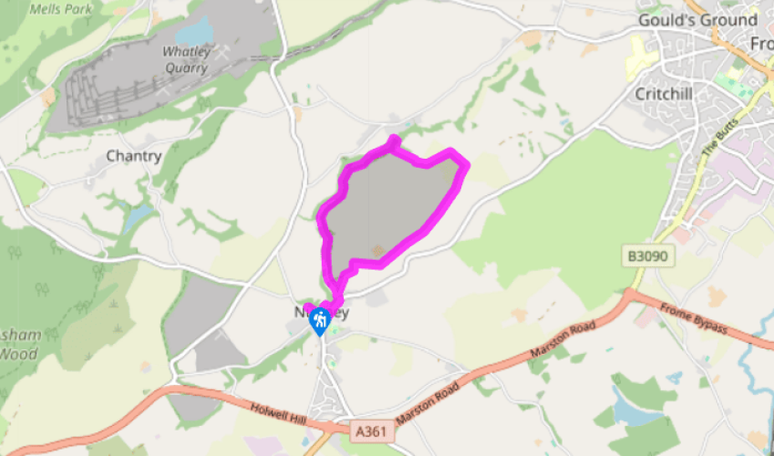
Walk directions
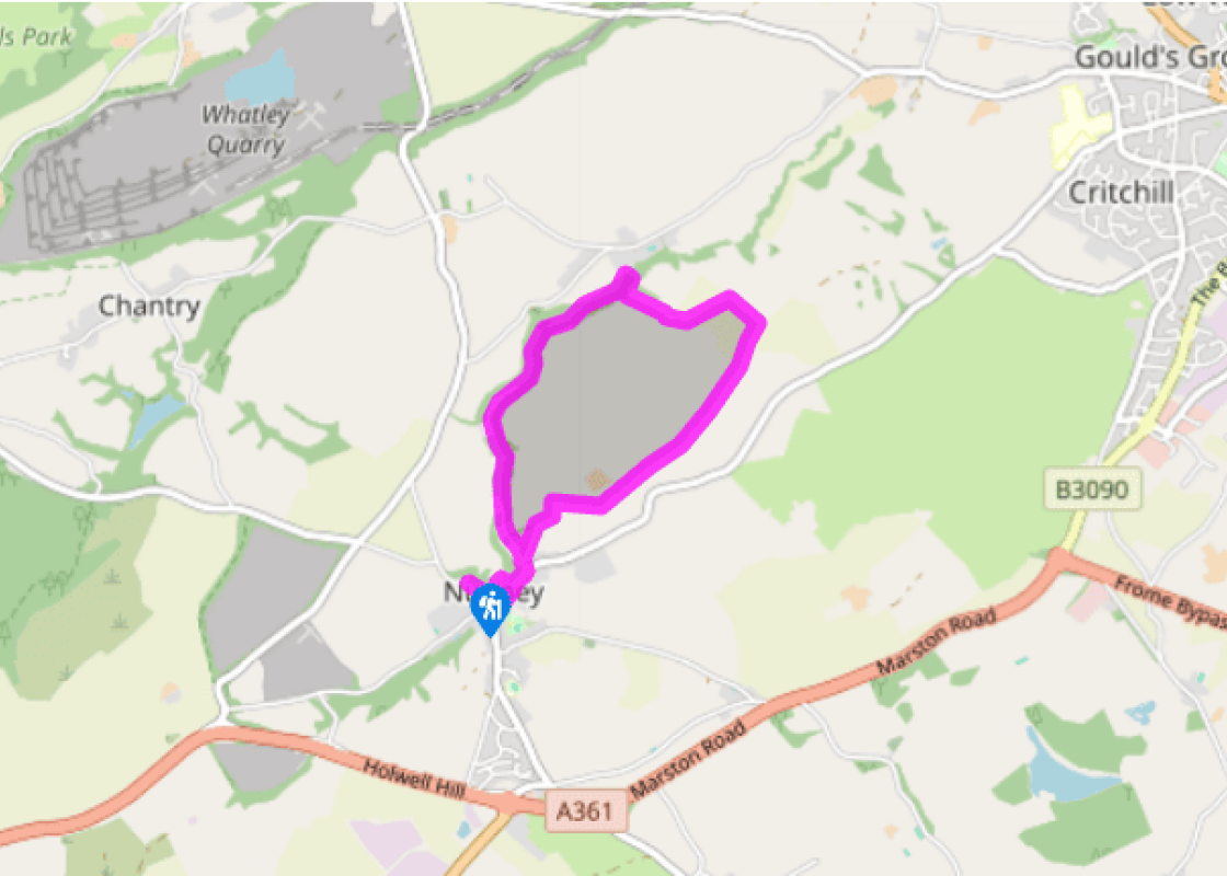
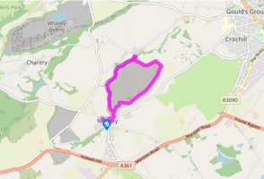
Head down into the village, turning left at De La Mare Café to Nunney Castle (entry is free). Having inspected the castle, cross a footbridge towards the church. Turn left in Church Street, past a stone cross. In another 55yds (50m), where the street starts uphill, turn left into Donkey Lane.
Follow the lane past a high wall on the left, to a gate with a signpost. Keep ahead, leaving the track after 150yds (137m) for a small gate ahead into woods. A wide path leads downstream with the Nunney Brook on its left. The sewage farm on the left is soon passed for pleasanter atmosphere of snowdrops or bluebells. After about 0.75 miles (1.2km) a track runs across the valley.
Turn left, as a signpost suggests, to cross the brook; immediately turn right past a disused stile. Continue along the stream on an often muddy path. Just after crossing concrete slabs, the path climbs away from the stream to join a track above. Turn right to cross the stream on a high, arched bridge. The track bends right, through a gate: as it bends back round to the left keep ahead to a waymarked kissing gate on the left.
Go up the right-hand side of a narrow field to a kissing gate. Continue uphill on the left-hand edge for just 65yds (60m) to a kissing gate in the hedge. Turn up right, next to the hedge, then left along the top of the field to a gap at its corner. As this is the crest of a broad ridge, there are now views ahead to the hills in the east.
Head down the left-hand side of the field into a slight dip. Ignore a half-hidden stile on the left but go through the gateway gap ahead. Now turn right and slant across the corner of the field to a visible kissing gate in the skyline hedge – this turns out to be two gates, one behind the other. Once through these, follow the left-hand edge of the long field ahead, with a tree belt to your left. At its far corner take a gateway gap to the left of a disused kissing gate and a field gate. Continue in same direction as before, but now with hedge on your right. At the field end cross a farm track via two gates. In another 150yds (137m), a kissing gate is on your right.
This leads into a narrow track between over-arching hedges. It bends to the left and then the right, then descends to become a street leading into Nunney. This runs down to join Donkey Lane on the outward route, with the church just 300yds (274m) ahead.
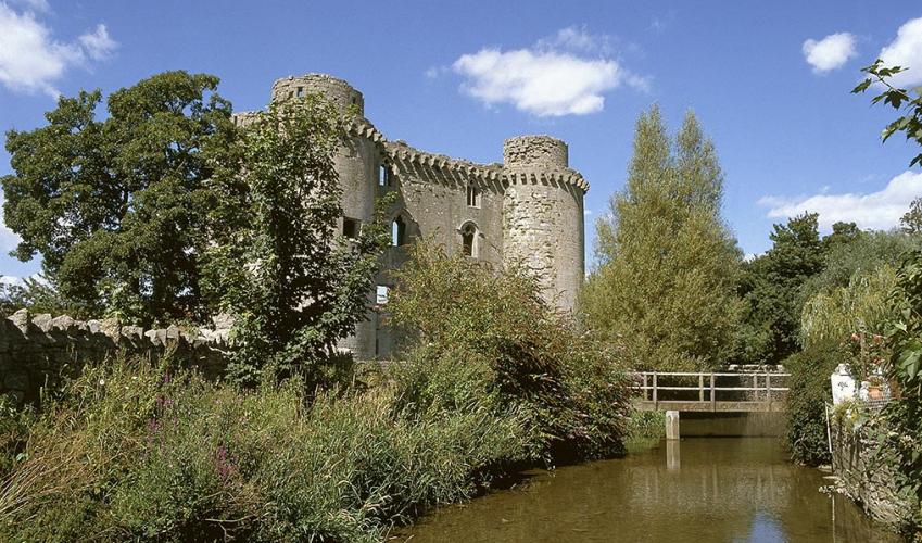
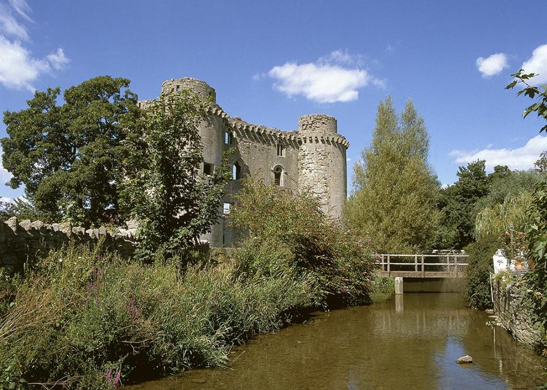
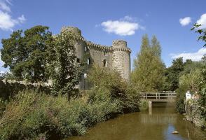
The castle at Nunney is awkward to spot, huddled down among the houses, but once found it will not be forgotten. Built in 1373 by Sir John de la Mare, it's a superb structure with large corner towers and a proper moat all the way round. Sir John had fought with the Black Prince in France, and his... gatehouse here included some of the very latest French fashions in construction. Through its ruined walls we catch glimpses of the swans and ducks in the moat and the rose-hung cottages of the village. The nearby village church, which is attractive in its own right, has interesting effigies of the De la Mere family over two centuries. Such effigies are of particular interest to costume designers, who otherwise would have no idea of what Elizabethan outfits looked like from the back. This is important when you're making a film such as Shakespeare in Love – Gwyneth Paltrow can't always be facing the camera! Also worth a look is the font cover from 1684, which is an ornate cone of carved wood. Although particular towns had particular loyalties during the Civil War (Wells for Royalist, Taunton for Parliamentarian), Somerset as a whole was not carried away into warfare. Indeed, a local, low-technology force of 'Clubmen' (the first bouncers?) was formed to discourage either side from entering the county. Armies brought inconvenience: 'such uncivil drinkers and thirsty souls that a barrel of good beer trembles at the sight of them, and the whole house nothing but a rendezvous of tobacco and spitting' wrote a Tolland farmer obliged to play host to the Parliamentarians in 1647. Still, Britain's civil wars must be considered civilised when compared with the Thirty Years' War which ravaged Germany around the same time, where the resulting famine and plague reduced the population of the countryside by a third of its former size. Taunton was besieged twice, and Bridgwater once. Somerset saw one battle, at Langport. Part of the Royalist army under Lord Goring had arrived too late to get defeated at the Battle of Naseby: Fairfax and the New Model Army caught up with them at the fords of the Wagg Rhyne and defeated them there instead. After the battle, Colonel Prater, its owner, took refuge in Nunney Castle with eight Irishmen. The villagers must have been alarmed at the prospect of a siege taking place right among their houses. In the event the castle fell without much of a fight, although one cannonball lodged in the wall of the nearby church. Afterwards the Roundheads deliberately ruined the castle to prevent its being reoccupied. Somerset's sufferings were to come 40 years later, in the Monmouth Rebellion.
Somerset remains rural and unspoiled, and ever popular areas to visit are the limestone and red sandstone Mendip Hills rising to over 1,000 feet, and by complete contrast, to the south and southwest, the flat landscape of the Somerset Levels. Another popular spot, the Quantocks, once the haunt of poets Coleridge and Wordsworth, are noted for their gentle slopes, heather-covered moorland expanses and red deer.
"Visit a stone-built village with a moated castle, once besieged in the Civil War, on this wander through woodland and pasture."
Walk details
1hr 15mins
Difficulty:
Easy
Gradient:
Gentle
Distance:
3 miles (4.8kms)
Ascent:
160ft (49m)
Walk directions
Head down into the village, turning left at De La Mare Café to Nunney Castle (entry is free). Having inspected the castle, cross a footbridge towards the church. Turn left in Church Street, past a stone cross. In another 55yds (50m), where the street starts uphill, turn left into Donkey Lane.
1 of 6
Follow the lane past a high wall on the left, to a gate with a signpost. Keep ahead, leaving the track after 150yds (137m) for a small gate ahead into woods. A wide path leads downstream with the Nunney Brook on its left. The sewage farm on the left is soon passed for pleasanter atmosphere of snowdrops or bluebells. After about 0.75 miles (1.2km) a track runs across the valley.
2 of 6
Turn left, as a signpost suggests, to cross the brook; immediately turn right past a disused stile. Continue along the stream on an often muddy path. Just after crossing concrete slabs, the path climbs away from the stream to join a track above. Turn right to cross the stream on a high, arched bridge. The track bends right, through a gate: as it bends back round to the left keep ahead to a waymarked kissing gate on the left.
3 of 6
Go up the right-hand side of a narrow field to a kissing gate. Continue uphill on the left-hand edge for just 65yds (60m) to a kissing gate in the hedge. Turn up right, next to the hedge, then left along the top of the field to a gap at its corner. As this is the crest of a broad ridge, there are now views ahead to the hills in the east.
4 of 6
Head down the left-hand side of the field into a slight dip. Ignore a half-hidden stile on the left but go through the gateway gap ahead. Now turn right and slant across the corner of the field to a visible kissing gate in the skyline hedge – this turns out to be two gates, one behind the other. Once through these, follow the left-hand edge of the long field ahead, with a tree belt to your left. At its far corner take a gateway gap to the left of a disused kissing gate and a field gate. Continue in same direction as before, but now with hedge on your right. At the field end cross a farm track via two gates. In another 150yds (137m), a kissing gate is on your right.
5 of 6
This leads into a narrow track between over-arching hedges. It bends to the left and then the right, then descends to become a street leading into Nunney. This runs down to join Donkey Lane on the outward route, with the church just 300yds (274m) ahead.
The castle at Nunney is awkward to spot, huddled down among the houses, but once found it will not be forgotten. Built in 1373 by Sir John de la Mare, it's a superb structure with large corner towers and a proper moat all the way round. Sir John had fought with the Black Prince in France, and his... gatehouse here included some of the very latest French fashions in construction. Through its ruined walls we catch glimpses of the swans and ducks in the moat and the rose-hung cottages of the village. The nearby village church, which is attractive in its own right, has interesting effigies of the De la Mere family over two centuries. Such effigies are of particular interest to costume designers, who otherwise would have no idea of what Elizabethan outfits looked like from the back. This is important when you're making a film such as Shakespeare in Love – Gwyneth Paltrow can't always be facing the camera! Also worth a look is the font cover from 1684, which is an ornate cone of carved wood. Although particular towns had particular loyalties during the Civil War (Wells for Royalist, Taunton for Parliamentarian), Somerset as a whole was not carried away into warfare. Indeed, a local, low-technology force of 'Clubmen' (the first bouncers?) was formed to discourage either side from entering the county. Armies brought inconvenience: 'such uncivil drinkers and thirsty souls that a barrel of good beer trembles at the sight of them, and the whole house nothing but a rendezvous of tobacco and spitting' wrote a Tolland farmer obliged to play host to the Parliamentarians in 1647. Still, Britain's civil wars must be considered civilised when compared with the Thirty Years' War which ravaged Germany around the same time, where the resulting famine and plague reduced the population of the countryside by a third of its former size. Taunton was besieged twice, and Bridgwater once. Somerset saw one battle, at Langport. Part of the Royalist army under Lord Goring had arrived too late to get defeated at the Battle of Naseby: Fairfax and the New Model Army caught up with them at the fords of the Wagg Rhyne and defeated them there instead. After the battle, Colonel Prater, its owner, took refuge in Nunney Castle with eight Irishmen. The villagers must have been alarmed at the prospect of a siege taking place right among their houses. In the event the castle fell without much of a fight, although one cannonball lodged in the wall of the nearby church. Afterwards the Roundheads deliberately ruined the castle to prevent its being reoccupied. Somerset's sufferings were to come 40 years later, in the Monmouth Rebellion.
Somerset remains rural and unspoiled, and ever popular areas to visit are the limestone and red sandstone Mendip Hills rising to over 1,000 feet, and by complete contrast, to the south and southwest, the flat landscape of the Somerset Levels. Another popular spot, the Quantocks, once the haunt of poets Coleridge and Wordsworth, are noted for their gentle slopes, heather-covered moorland expanses and red deer.