


Waterlake Cottage
Ground floor sleeps 4+baby. 2 bedrooms, 2 bathrooms, large kitchen/dining room, large lounge,…

Chitterne
7 miles (11.3kms)
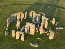
When you think of Salisbury Plain the image that usually springs to mind is an undulating chalk plateau, a hostile, desolate place with much evidence of military activity and a tangible air of ancient mystery. Salisbury Plain and the whole of North Wessex were once the most heavily populated areas in the country, inhabited by the people of the late Stone Age. Ironically, today, in this overcrowded island of ours, the Plain is one of the loneliest and least populated tracts of land in the south of England, if not all of Britain. The Plain has a timeless quality and there is a very good reason for this. The Ministry of Defence first conducted exercises on Salisbury Plain in the late 1890s and between then and World War II sizeable chunks of land were acquired for training. The MOD now own 150sq miles (390sq km) of land here, making it the largest military training area in the United Kingdom. Of this about 39sq miles (100sq km) is permanently off limits to the public, with access greatly restricted in other areas.
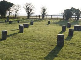
As military use of Salisbury Plain increased, new camps sprang into existence. Imber, one of the region’s best-known villages, was evacuated to enable training for Operation Overlord, crucial to the outcome of World War II, to take place in 1944. The villagers never returned to their homes after the war and the remains of Imber continue to be used for training.One of the best ways to explore Salisbury Plain is by following the 30-mile (48km) Imber Range Perimeter Path, which, although it keeps to the edge of the Plain, does evoke a strong sense of adventure and give a real flavour of the area. The views from the trail are particularly impressive. The outward leg of this walk follows the Imber Range Perimeter Path over the southern slopes of the Plain.
The backdrop is dramatic and in places you can see how Salisbury Plain has remained untouched by modern intensive farming. As a result it is one of the last surviving chalk grassland areas in Britain, probably Europe. The entire region is designated a Site of Special Scientific Interest (SSSI). Salisbury Plain also includes various archaeological sites, which have thankfully remained intact over the years, and through lack of use in recent years the place has become a fascinating haven for wildlife. Twenty pairs of stone curlews breed on the Plain and other breeding species include buzzards, barn owls, nightingales and corn buntings.
Salisbury Plain has captured the imagination of some of our greatest writers and artists, too. William Wordsworth and Thomas Hardy wrote about this unique landscape and Constable chose it as one of his subjects.
From the parking area turn left to the T-junction. Keep right, signposted Warminster and Codford, pass the Kings Head and continue along the main road through the village. When the road bends left veer right to join a byway (Imber Range Perimeter Path).
Follow the sunken track between trees and further up they give way to open downland. Cross a track and keep ahead to a copse. On reaching the Military Road continue on the Imber Range Perimeter Path. After about 200yds (183m), bear left at the fence corner and continue on the byway. Avoid a turning down to a small copse enclosing farm outbuildings and head up the slope to the next junction.
Turn left, heading south on a byway, and re-cross the Military Road at a staggered junction. Continue south on the byway, passing barns on the left. Cross the B390 road and follow the byway as it climbs steadily alongside woodland on the left. Pass a corrugated barn on the right and after about 120yds (110m) swing left through a metal gate by a cattle grid.
Follow the byway with trees and the outline of Upton Great Barrow on the left. On reaching a cattle grid and track junction keep ahead on the byway to the next gate and cattle grid. Turn left, then right after about 75yds (69m) to follow a bridleway. Across the field go through several gates and maintain direction, heading towards trees and keeping fencing on your left. Follow the path as it bends right in the field corner and drop down to a metal gate. Pass through it and follow the field-edge downhill to a concrete track.
Turn left, where the bridleway runs straight on, and follow the track to where it curves left by a gate. Keep over to the right and follow the field boundary. Make for a gate on the far side of the field and enter the next pasture. Follow the right-hand edge all the way to a stile on the right.
Cross it and keep right to a footbridge in the field corner. The bridge has stiles either end of it. Cross them and continue along the field edge for a short distance to the next stile. Cross it to the road and turn left, back to Chitterne. At the junction near the Kings Head, turn right and return to the church and parking area.
Byway, bridleway, footpath, several stretches of road, several stiles
Downland and farmland. North of the B390 the land is owned by the MOD with strict bylaws. South of the road the land is civilian-owned
On lead and under close control on outward leg of walk and on road sections
OS Explorer 143 Warminster & Trowbridge
In vicinity of Chitterne Church
None on route
Read our tips to look after yourself and the environment when following this walk.
A land shrouded in mystery, myth and legend, Wiltshire evokes images of ancient stone circles, white chalk horses carved into hillsides, crop circles and the forbidden, empty landscape of Salisbury Plain. To many M4 and A303 drivers heading out of London through the clutter of the Thames Valley, Wiltshire is where the landscape opens out and rural England begins.
Wiltshire’s charm lies in the beauty of its countryside. The expansive chalk landscapes of the Marlborough and Pewsey downs and Cranborne Chase inspire a sense of space and freedom, offering miles of uninterrupted views deep into Dorset, Somerset and the Cotswolds. Wiltshire’s thriving market towns and picturesque villages provide worthwhile visits and welcome diversions. Stroll through quaint timbered and thatched villages in the southern Woodford and Avon valleys and explore the historic streets of the stone villages of Lacock, Castle Combe and Sherston. Walk around Salisbury and discover architectural styles from the 13th century to the present and take time to visit the city’s elegant cathedral and fascinating museums. And if all of that isn’t enough, the county is also richly endowed with manor houses, mansions and beautiful gardens.
Discover more than 15,000 professionally rated places to stay, eat and visit from across the UK and Ireland.
Choose a place to stay safe in the knowledge that it has been expertly assessed by trained assessors.
Search by location or the type of place you're visiting to find your next ideal holiday experience.
Read our articles, city guides and recommended things to do for inspiration. We're here to help you explore the UK.