
Drovers Rest
Just off the A68 between the beautiful Northumberland National Park and Kielderhead National…

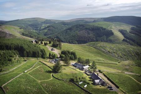
Byrness
14 miles (24.6kms)
After leaving the forests above Byrness, this walk heads for the hills and never sees forest again. It’s a long, hard route, with escape points being few and far between, but the views are far-reaching and exciting. There’s a great sense of solitude as you stride out along the border ridge, mostly in England, but occasionally straying into Scotland. The walk reaches a high point of 2,030ft (619m) at Windy Gyle before dropping to Clennell Street, where walkers need to decide which way they want to descend from the ridge to return to civilization.
From the village centre, walk southeast along the A68 and then, just before St Francis Church, take the surfaced path on the left – almost turning back on yourself. Joining a lane at the top, go through a gate just after Byrness Cottage. A path then climbs steeply up to Byrness Hill, from where there are impressive views over Redesdale.
The route heads north, from Saughy Crag to Houx Hill, over flagstones, then above Windy Crag to Ravens Knowe. The land to the east is owned by the Ministry of Defence, part of the ‘dry training area’. From Ravens Knowe the route makes for Ogre Hill and follows a clear but often boggy path downhill alongside a forest plantation to a fence and stile at the headwaters of the River Coquet.
This rather undramatic feature marks the Scottish border and it is very satisfying to climb over the ladder-stile and set foot on Scottish peat. The path sets out north, uphill, as if heading for the Highlands, but in fact the route is simply avoiding the worst of the mires of the Coquet watershed and it soon turns right to follow the valley eastwards, descending gradually to a large gate and stile beside the gathering stream.
Beyond the gate lies a scatter of grass-covered earthworks, extensive and difficult to interpret. This is Chew Green, a Roman marching camp, used for centuries as a stop-over en route to the wild north. A road runs just the other side of the Coquet and there is a small car park. It is a long drive anywhere from here; left heads along Coquetdale to Alwinton, right is an MoD road leading to Redesdale (it is only open at certain times or by special arrangement).
From Chew Green, the Way follows the grassy course of Dere Street up to the border ridge, to the right of Brownhart Law. Continuing north, Dere Street soon disappears beyond Gaisty Law towards Woden Law, where the Romans practised battle and siege tactics. The route heads north or northeast, following a path away from the border fence, linking cairns on the hilltops. The ground is peaty and often boggy but there are bridges, boardwalks or flagstones over the worst sections. Vegetation on these exposed hills is thin, usually mat-grass with some heather and drifts of purple moor-grass, which bleaches white in the winter and spring. After about a mile (1.6km) the route bears right and heads eastwards at the head of the Rennies Burn. Past the Grassy Loughs, the route meets up again with the border fence and keeps with this for many miles, so that routefinding is no longer a problem. It is easy to become disorientated in the Cheviots. The views seem to go on forever.
After a sharp turn left in the border fence, the route leads to one of the wooden Pennine Way shelters at Yearning Saddle. Although far from comfortable, the shelter offers a respite if the weather has closed in. Lamb Hill is the next summit, then Beefstand Hill, then Mozie Law. They are all excellent vantage points and the route links them like pearls on a necklace. To the north, the distinctive hills in the middle distance are the Eildon Hills, close to Melrose. On the descent the eye is caught by a very obvious path off to the right, following a grassy ridge. The path is called the Street, an ancient border crossing once used as a drove road. The Pennine Way heads eastwards, brushing the border fence at Plea Knowe at the head of the Street, then cutting the corner at Foul Step. Ahead now rises Windy Gyle, and the path leaves the border fence to climb to its summit.
Windy Gyle is certainly one of the finest features on the whole Pennine Way and from the top the panorama is breathtaking. At 2,030ft (619m), there is a view over most of the Cheviot massif. The big hills to the left of Kidland Forest are Bloodybush Edge, with Cushat Law behind. To the northeast are the even higher summits of The Cheviot and Hedgehope. The route descends northeastwards, heading down the ridge to meet another cross-border drove road called Clennell Street. This marks the end of stage seven, but walkers now need to decide whether to head northeast to the nearest road at Cocklawfoot, which is 2.2 miles (3.5km) away, or to head south to Alwinton, the nearest village, which is 7.6 miles (12.2km) away.
Some road walking at start; forest track; high ridge path, boggy in places
Short section of forest; then high, exposed hills
On lead at all times
OS Explorer OL 16
Roadside parking in Byrness
None on route
<p>This is a high and exposed hill route that is best avoided in bad weather. It ends at a remote border crossing that is 2.2 miles (3.5km) from the nearest road – at Cocklawfoot – and 7.6 miles (12.2km) from the nearest village – Alwinton. </p>
Read our tips to look after yourself and the environment when following this walk.
Discover more than 15,000 professionally rated places to stay, eat and visit from across the UK and Ireland.
Choose a place to stay safe in the knowledge that it has been expertly assessed by trained assessors.
Search by location or the type of place you're visiting to find your next ideal holiday experience.
Read our articles, city guides and recommended things to do for inspiration. We're here to help you explore the UK.