

Rhydolion
A peaceful small site with good views on a working farm close to the long sandy beach at Heels…

A dramatic coastal walk round Mynydd Cilan from Porth Neigwl (Hell’s Mouth)
Porth Neigwl
6.5 miles (10.5kms)
Porth Neigwl and Hell’s Mouth are alternative names for the wide, open bay stretching between Rhiw and Llanengan on the Llyn’s south coast. Facing southwest, into the prevailing winds, the bay bears the brunt of the powerful Atlantic swells pushing up the Irish Sea. In the days of sail, the strong winds made the bay lethal for shipping, and over 30 vessels are known to have been wrecked there within the last hundred years. It was doubtless this unenviable reputation as a ships’ graveyard that led rise to the name ‘Hell’s Mouth’. Today, these conditions attract surfers from all over the UK.
The origins of the original Welsh name is less clear. The bay may have been named after Nigel de Loreyng, who landed here after serving in the Battle of Poitiers (1356), or come from an unknown Irish word. During the early medieval period, there was considerable Irish settlement along the Llyn coast, and the peninsula’s name is itself thought to be derived from an Irish tribe called the Laigin.
Walking along the sand and shingle beach, you will witness one of the most striking examples of sea erosion in Wales. Unlike the hard, rocky headlands at either end of the bay, the soft, crumbly beach cliffs of boulder clay disintegrate easily when pounded by storm waves. As a result, the coastline at Porth Neigwl is retreating at an average rate of a foot (0.3m) a year – enough to turn Mynydd Cilan into an island within the next millennium.
Both Porth Neigwl and the headland of Mynydd Cilan are important wildlife habitats. Summer visitors include the Arctic tern and the little tern, which feed on small fish in the bay, while porpoises may occasionally be seen out at sea. Along the beach cliffs, look out for clusters of small yellow flowers on little woolly cushions: these are kidney vetch.
Mynydd Cilan’s coastal heathland provides a different but equally important habitat, dotted with small pools and criss-crossed with traditional earth banks or cloddiau. Species to look out for include stonechats, wheatears and breeding choughs, as well as reptiles like the common lizard and the adder. The heath is at its most beautiful in the summer, when the gorse and heather are both in flower and vibrant with colour.
Follow a sandy path from the car park to the beach and turn left. Near the end of the beach, climb up to the grassy bank on your left and continue to a stile. Bear half left across a field to join an ascending track. Keep ahead at a right-hand bend and descend to a stile in a valley.
Cross the stile and turn left towards another. Climb this and keep ahead up a bank, passing through a gap in a fence at the top. Turn right and follow the fence up a field, bearing left near the top to locate a waymarked gate. Continue ahead on a grassy path, joining a track by a farm.
About 120yds (110m) after the farm, turn right through a small metal gate and bear left towards some old stone outbuildings. Keep ahead past these to a cottage and continue onto a track. Bear left and then immediately right to join a path through a series of small fields towards a chapel.
Go past the chapel and turn right on a lane. After about 660yds (604m), bear left onto a track towards Muriau farm (‘Wales Coast Path’). Just before the farm, bear right at a kissing gate and descend through a series of fields. Continue down to the sea along a rough track with a stream to the right.
With the sea ahead, bear right and join a clear coastal path. Ignore any gates and stiles to the right and follow the clifftop onto open common near Trwyn Cilan. Don’t be drawn by a clear grassy track to the right, but keep ahead to follow the cliff edge out to the headland and round to the right.
About three-quarters of a mile (1.2km) to the north of Trwyn Cilan, pass to the left of a trig point and covered reservoir. With Porth Neigwl now visible ahead, continue along the cliffs, following the waymarked Wales Coast Path. This will eventually return you to the beach at Porth Neigwl where you retrace your steps back to the car park.
Well-marked coast path and field paths; some mud possible in winter
Sand and shingle beach, pastured fields, coastal heath
Should be kept on a lead in fields where cattle are likely, but could run free on the beach
OS Explorer 253 Lleyn Peninsula West
Small car park behind Porth Neigwl (Hell’s Mouth)
Community toilet at The Sun in Llanengan
<p>The Wales Coast Path to the immediate east of Porth Neigwl may be realigned as the path develops</p>
Read our tips to look after yourself and the environment when following this walk.
The county of Gwynedd is home to most of the Snowdonia National Park – including the wettest spot in Britain, an arête running up to Snowdon’s summit that receives an average annual rainfall of 4,473mm. With its mighty peaks, rivers and strong Welsh heritage (it has the highest proportion of Welsh-speakers in all of Wales), it’s always been an extremely popular place to visit and live. The busiest part is around Snowdon; around 750,000 people climb, walk or ride the train to the summit each year.
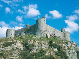
Also in Gwynedd is the Llyn Peninsula, a remote part of Wales sticking 30 miles out into the Irish Sea. At the base of the peninsula is Porthmadog, a small town linked to Snowdonia by two steam railways – the Welsh Highland Railway and the Ffestiniog Railway. Other popular places are Criccieth, with a castle on its headland overlooking the beach, Pwllheli, and Abersoch and the St Tudwal Islands. Elsewhere, the peninsula is all about wildlife, tranquillity, and ancient sacred sites. Tre’r Ceiri hill fort is an Iron Age settlement set beside the coastal mountain of Yr Eifl, while Bardsey Island, at the tip of the peninsula, was the site of a fifth-century Celtic monastery.
Discover more than 15,000 professionally rated places to stay, eat and visit from across the UK and Ireland.
Choose a place to stay safe in the knowledge that it has been expertly assessed by trained assessors.
Search by location or the type of place you're visiting to find your next ideal holiday experience.
Read our articles, city guides and recommended things to do for inspiration. We're here to help you explore the UK.