Revitalise Respite Holidays (Jubilee Lodge)
At the fringes of Epping Forest, Jubilee Lodge blends the rural attractions and seaside resorts…

A wildlife wander on the site of the former RAF Chigwell.
Roding Valley
3 miles (4.8kms)
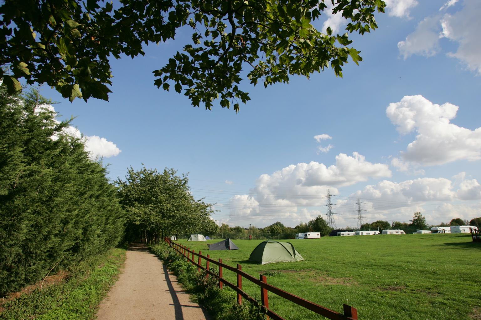
Roding Valley Meadows nature reserve covers approximately 160 acres (65ha) and is situated on traditionally managed hay meadows, which were occupied from 1938 to 1964 by RAF Chigwell. More than 3,500 people lived and worked here in more than 100 buildings, which included hangars, a theatre, a post office, a chapel and a shop. Long since demolished, it’s hard to believe that such a vibrant community once occupied this nature reserve with its peaceful paths and meadows.
The area was made a nature reserve in 1986 and is now managed by the Essex Wildlife Trust. A number of features from the former site still exist, including the rotundas from where barrage balloons were launched to protect Essex, Hertfordshire and north London from air raids during World War II.
As the largest surviving area of traditionally managed river-valley habitat in Essex, the reserve is home to a wide range of wildlife. In spring and summer you might see sedge warblers and reed buntings, and in late summer look out for flocks of finches on the seed heads of thistle and teasel. Many beautiful wild flowers, such as southern marsh orchids, also thrive in the meadows. These are managed to replicate the centuries-old system of grazing and hay-cutting.
The large grassy area of Lower Mead at Point 4 is rich in flora and cut regularly in summer for hay. When combined with winter grazing by long-horn cattle, this is a traditional method of looking after grassland and encourages wild flowers to grow. These are particularly colourful from mid-May. Devil’s-bit scabious – a tall plant with rounded purple-blue flowers that look like pin cushions – grows well here, as do the frothy, yellow flowers of lady's bedstraw, which smell of honey and hay. The nearby hedges are vital wildlife corridors and help to make up almost 10 miles (16.1km) of hedgerow that is managed by laying and coppicing.
When the M11 was constructed it sliced through the ancient green lane which you’ll walk along the route. Despite this, the old route contains an incredible variety of trees and shrubs including ash, oak, elder, blackthorn, dogwood, hornbeam, crab apple and hazel. You may also see flowering plants such as honeysuckle, bluebell and foxglove.
From the information board at the entrance by the kissing gate there are two paths. The one straight ahead is wide and gravelly, but to start the walk take the path on the right and go up the steps of the steep embankment. This narrow hillside was created from earth dug out during the construction of the M11 but is seldom used, and has become an excellent hunting ground for kestrels and sparrowhawks. Much of the original site of the RAF base now lies beneath the motorway. Also from here you can look down on the recreation area and the lake which, although not part of the reserve, is a popular spot for waterfowl. After exploring this area return to your starting point and take the main path through the kissing gate into the reserve. Follow the path through the reserve and, ignoring paths branching off to the right and left, keep ahead, passing oak and hornbeam. The concrete area you will pass marks the site of RAF Chigwell. Continue along the concrete track and join the widest track ahead through the woodland. The track curves and becomes concrete again before reaching a grassy roundabout surrounded by open meadow. The seating here provides a good picnic area and a place to watch for skylarks nesting in the meadow ahead.
Go through a gate and follow the narrow path across a field that leads away from the concrete roundabout towards the M11. Go through a hedge gap and a kissing gate where there is a ‘footpath No. 8’ waymark, and continue along an enclosed path to the right of Four Acres Field.
At the cross-path leading to a bridge over the M11, turn left away from the road along the ancient green lane which once formed part of the drovers’ and packhorse route from Epping Forest to Romford market. Turn right at a yellow-waymarked fingerpost at a cross-path, and cross a plank bridge. Go through the adjacent kissing gate and continue along the left-hand edge of a field. Cross another plank footbridge and head towards the tall, thin chimney which is a Victorian vent for underground sewers.
Go through a kissing gate into the large grassy area known as Lower Mead, following the waymark, and bear left. Go through another kissing gate and bear right. The path now continues with the River Roding to your right, providing a habitat for kingfishers, dragonflies, damselflies, bream and sticklebacks. After 300yds (274m), cross the river on Charlie Moule’s Footbridge, built in the 1950s to replace stepping stones. Turn left after the footbridge along a concrete path, with the river on your left. Follow this meandering path beside the river bank, crossing a small wooden footbridge. Later the path veers away from the river and ahead, through the trees, you will see a lake. This is a good place to watch wildfowl such as Canada geese, mallard ducks, moorhens and coots. The lake was dug to provide the nearby M11 with gravel. Keep ahead towards the lake, pass a cricket pavilion and follow the concrete path as it curves right at a yellow post. A few paces further on, cross White Bridge over the River Roding, and re-enter the nature reserve.
Turn left in the direction of the red waymark and go through a kissing gate, later bearing away from the river to join a gravel path. Turn right and retrace your steps back to the start of the walk.
Wide byways, tracks and riverside footpaths
Riverbank, open meadows and some urban views
Positively dog friendly, no stiles and off lead
OS Explorer 174 Epping Forest & Lee Valley
Small (free) car park by David Lloyd Club off Roding Lane
None on route
Read our tips to look after yourself and the environment when following this walk.
Essex is full of pleasant surprises. It has the largest coastline of any county in England, with its fair share of castles, royal connections and scenic valleys. Take Colchester, for example, which was built by the Romans and is Britain’s oldest recorded town. Its castle contains the country’s largest Norman keep and yet, a stone’s throw from here, East Anglia’s newest arts centre promises to put Colchester firmly on the map as Essex’s capital of culture.
Tidal estuaries are plentiful and their mudflats offer migrating birds a winter feeding place. Essex was known as the land of the East Saxons and for centuries people from all over Europe settled here, each wave leaving its own distinctive cultural and social mark on the landscape. Walking a little off the beaten track will lead you to the rural retreats of deepest Essex, while all over the county there are ancient monuments to explore:
Discover more than 15,000 professionally rated places to stay, eat and visit from across the UK and Ireland.
Choose a place to stay safe in the knowledge that it has been expertly assessed by trained assessors.
Search by location or the type of place you're visiting to find your next ideal holiday experience.
Read our articles, city guides and recommended things to do for inspiration. We're here to help you explore the UK.