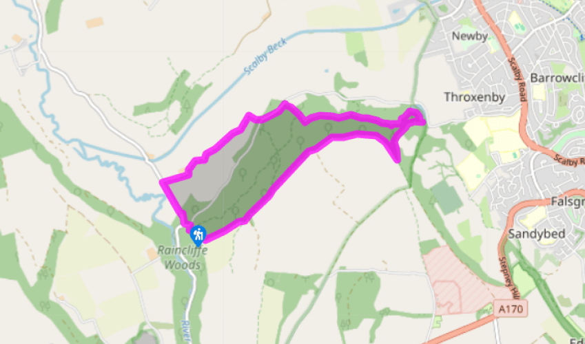
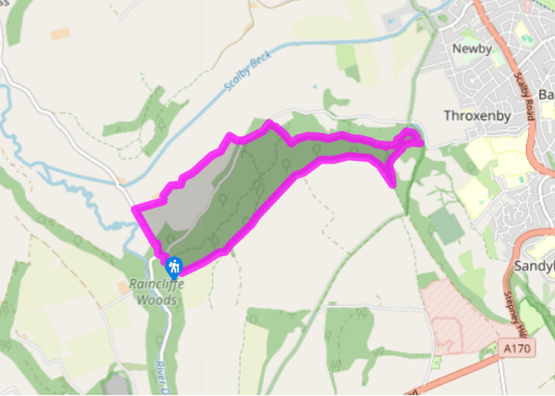
From the car park, turn left on the road, then right at the junction. Go downhill, and after the woodland ends, pass houses on the right. Opposite a bungalow, turn right down a track to Thorn Park Farm. Follow the track as it bends left by the farm buildings, then right past a cottage to a metal gate. Continue to follow the track, which bends left then right, then pass through two gateways.
Just before the next gateway, turn right and walk up the field side to go through a gateway, which takes you on a short path to the road. Go straight across onto a woodland path, bearing left parallel with the road, to reach a car park.
Go through the car park towards a signboard, then go uphill on the path ahead. Where the main path bends right, go straight ahead, more steeply, to reach a crossing, grassy track. Turn left and follow the path back into the woodland. Where it forks, take the right-hand path.
After 500yds (457m) look out for a path on the left, near a post with a red disc and white arrow, which immediately bends right over a drainage runnel. The path goes down into a small valley. Turn left, downhill, then follow the now-obvious path as it bends right again, past an old quarry. The path descends to reach Throxenby Mere. Turn right along the edge of the Mere – this part of the path is on boardwalks.
Just before you reach a picnic place, go right by a gate and take the path which goes up steeply through the woods, ignoring all joining paths until it reaches a track at the very top of the hill.
Turn right and follow the path for a mile (1.6km), parallel with first a fence and then a wall. It passes through a gateway with a stile by it and eventually reaches a gate.
Do not go through this gate out into fields, but go up to it, turn right and continue beside the wire fence on the edge of the woodland. At a post with a blue disc and arrow, where the main path swings left and another goes right, go straight ahead, downhill. When the path joins another go left, down steps and over a boardwalk bridge and down more steps to meet a crossing path.
Turn right and follow the path, which soon descends to the car park at the start of the walk.
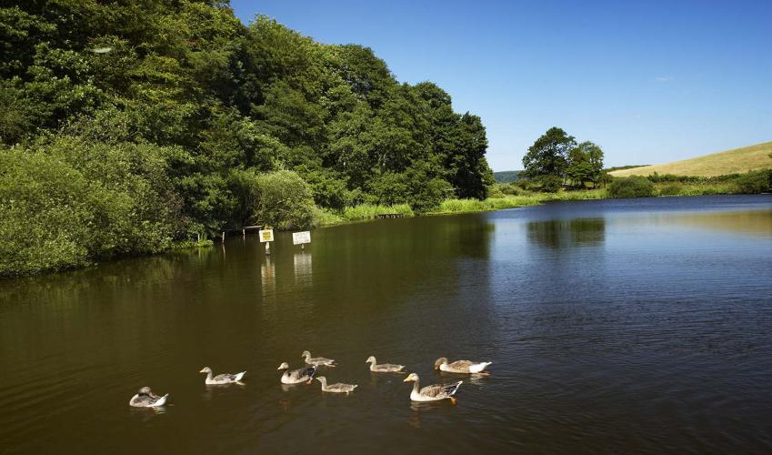
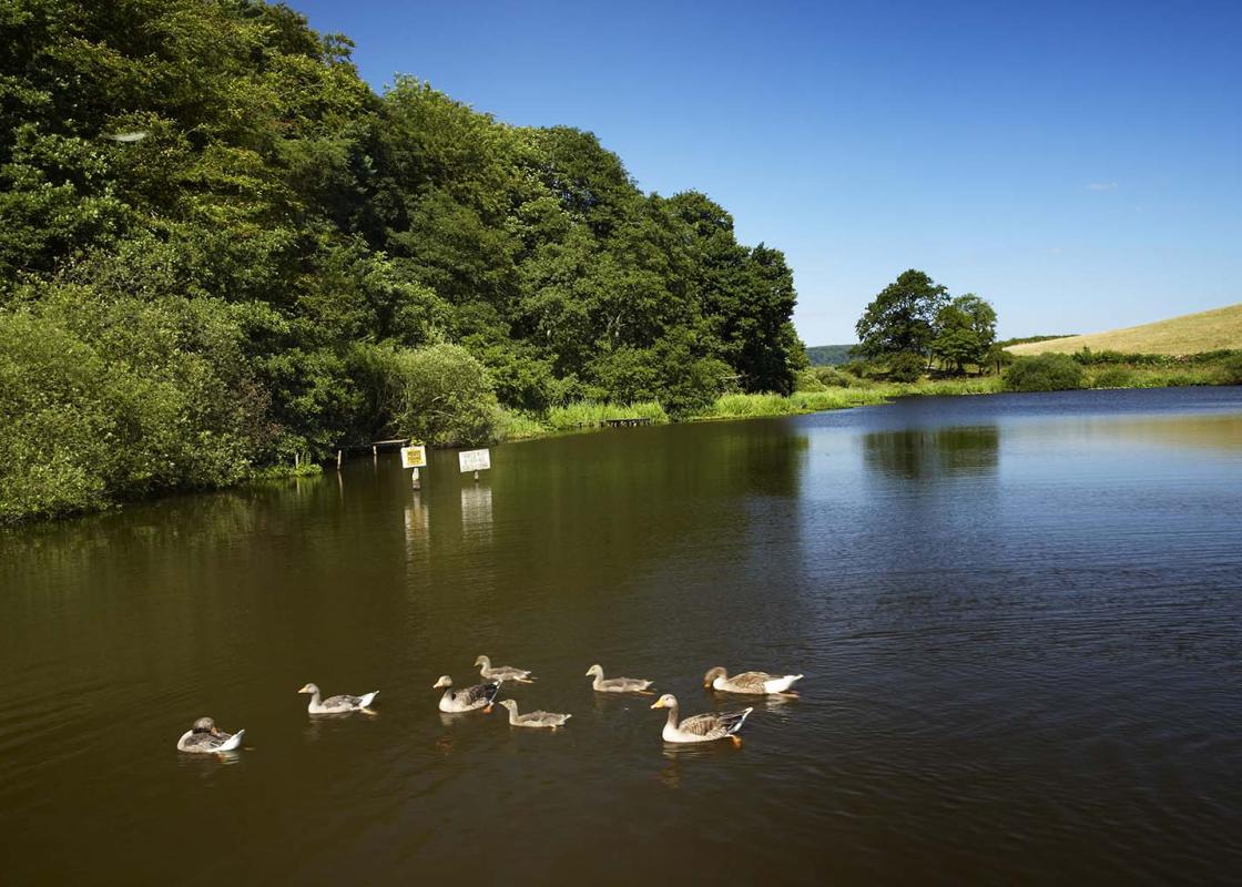
The steep hillside of Raincliffe Woods overlooks a deep valley carved out in the ice ages. Although mostly replanted in the 1950s and 1960s, the woods in places retain remnants of ancient oak and heather woodland – look out for the heather and bilberry bushes beneath oak trees that will show you... where. The woods have long been open to the public, though in the 19th century they were privately owned by the 1st Earl of Londesborough, and some of the roads and tracks were named after his family – Lady Edith’s Drive after his wife and Lady Mildred’s Ride after her sister. Lord Londesborough was the grandfather of Edith, Osbert and Sacheverell Sitwell. Osbert recalled in his autobiography Left Hand Right Hand! how he and Edith were taken in the early years of the 20th century on hair-raising drives by their grandfather in his buckboard through Raincliffe Woods. They would then walk up the steep hillsides through columbine and honeysuckle. Unfortunately, they often became lost, and the Earl’s language was, for a time, immoderate, until he remembered the children’s presence. Beetle enthusiasts wax lyrical about Throxenby Mere. The last vestiges of the huge glacial lake that formed more than 15,000 years ago, after the ice age, it contains species of rare water beetles, and is one of the places in the North of England to which coleopterists (beetle students to the layman) make tracks. You will also find the distinctive pinky-purple flowers and wide leaves of the broadleaved willowherb on its fringes. Throughout the walk you will come upon humps and banks, depressions and pits that show that this hillside has been a hive of human activity in the past. As the path approaches Throxenby Mere it crosses part of a Bronze Age dyke system, while elsewhere are medieval banks and the remains of pits for charcoal burning. You will also pass a small quarry which was used for local building stone. In the valley below Raincliffe Woods is the Sea Cut, or North Back Drain, a flood relief channel that runs for 3 miles (4.8km) from the River Derwent to Scalby Beck. Engineered in 1806 by local man, Sir George Caley, it takes excess water from the Derwent to the sea at Scalby to prevent flooding in the Vale of Pickering. Operation is by means of a sluice gate (now remotely controlled) 825yds (755m) west of Mowthorpe Bridge near the beginning of the walk. When in operation, it restores the Derwent’s link to the sea that was lost when glacial deposits blocked its original route.
North Yorkshire, with its two National Parks and two designated Areas of Outstanding Natural Beauty, is England’s largest county and one of the most rural. This is prime walking country, from the heather-clad heights of the North York Moors to the limestone country that is so typical of the Yorkshire Dales – a place of contrasts and discoveries, of history and legend.
From the car park, turn left on the road, then right at the junction. Go downhill, and after the woodland ends, pass houses on the right. Opposite a bungalow, turn right down a track to Thorn Park Farm. Follow the track as it bends left by the farm buildings, then right past a cottage to a metal gate. Continue to follow the track, which bends left then right, then pass through two gateways.
1 of 8
Just before the next gateway, turn right and walk up the field side to go through a gateway, which takes you on a short path to the road. Go straight across onto a woodland path, bearing left parallel with the road, to reach a car park.
2 of 8
Go through the car park towards a signboard, then go uphill on the path ahead. Where the main path bends right, go straight ahead, more steeply, to reach a crossing, grassy track. Turn left and follow the path back into the woodland. Where it forks, take the right-hand path.
3 of 8
After 500yds (457m) look out for a path on the left, near a post with a red disc and white arrow, which immediately bends right over a drainage runnel. The path goes down into a small valley. Turn left, downhill, then follow the now-obvious path as it bends right again, past an old quarry. The path descends to reach Throxenby Mere. Turn right along the edge of the Mere – this part of the path is on boardwalks.
4 of 8
Just before you reach a picnic place, go right by a gate and take the path which goes up steeply through the woods, ignoring all joining paths until it reaches a track at the very top of the hill.
5 of 8
Turn right and follow the path for a mile (1.6km), parallel with first a fence and then a wall. It passes through a gateway with a stile by it and eventually reaches a gate.
6 of 8
Do not go through this gate out into fields, but go up to it, turn right and continue beside the wire fence on the edge of the woodland. At a post with a blue disc and arrow, where the main path swings left and another goes right, go straight ahead, downhill. When the path joins another go left, down steps and over a boardwalk bridge and down more steps to meet a crossing path.
7 of 8
Turn right and follow the path, which soon descends to the car park at the start of the walk.
The steep hillside of Raincliffe Woods overlooks a deep valley carved out in the ice ages. Although mostly replanted in the 1950s and 1960s, the woods in places retain remnants of ancient oak and heather woodland – look out for the heather and bilberry bushes beneath oak trees that will show you... where. The woods have long been open to the public, though in the 19th century they were privately owned by the 1st Earl of Londesborough, and some of the roads and tracks were named after his family – Lady Edith’s Drive after his wife and Lady Mildred’s Ride after her sister. Lord Londesborough was the grandfather of Edith, Osbert and Sacheverell Sitwell. Osbert recalled in his autobiography Left Hand Right Hand! how he and Edith were taken in the early years of the 20th century on hair-raising drives by their grandfather in his buckboard through Raincliffe Woods. They would then walk up the steep hillsides through columbine and honeysuckle. Unfortunately, they often became lost, and the Earl’s language was, for a time, immoderate, until he remembered the children’s presence. Beetle enthusiasts wax lyrical about Throxenby Mere. The last vestiges of the huge glacial lake that formed more than 15,000 years ago, after the ice age, it contains species of rare water beetles, and is one of the places in the North of England to which coleopterists (beetle students to the layman) make tracks. You will also find the distinctive pinky-purple flowers and wide leaves of the broadleaved willowherb on its fringes. Throughout the walk you will come upon humps and banks, depressions and pits that show that this hillside has been a hive of human activity in the past. As the path approaches Throxenby Mere it crosses part of a Bronze Age dyke system, while elsewhere are medieval banks and the remains of pits for charcoal burning. You will also pass a small quarry which was used for local building stone. In the valley below Raincliffe Woods is the Sea Cut, or North Back Drain, a flood relief channel that runs for 3 miles (4.8km) from the River Derwent to Scalby Beck. Engineered in 1806 by local man, Sir George Caley, it takes excess water from the Derwent to the sea at Scalby to prevent flooding in the Vale of Pickering. Operation is by means of a sluice gate (now remotely controlled) 825yds (755m) west of Mowthorpe Bridge near the beginning of the walk. When in operation, it restores the Derwent’s link to the sea that was lost when glacial deposits blocked its original route.
North Yorkshire, with its two National Parks and two designated Areas of Outstanding Natural Beauty, is England’s largest county and one of the most rural. This is prime walking country, from the heather-clad heights of the North York Moors to the limestone country that is so typical of the Yorkshire Dales – a place of contrasts and discoveries, of history and legend.