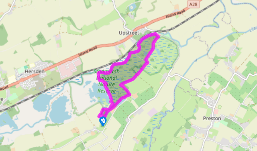
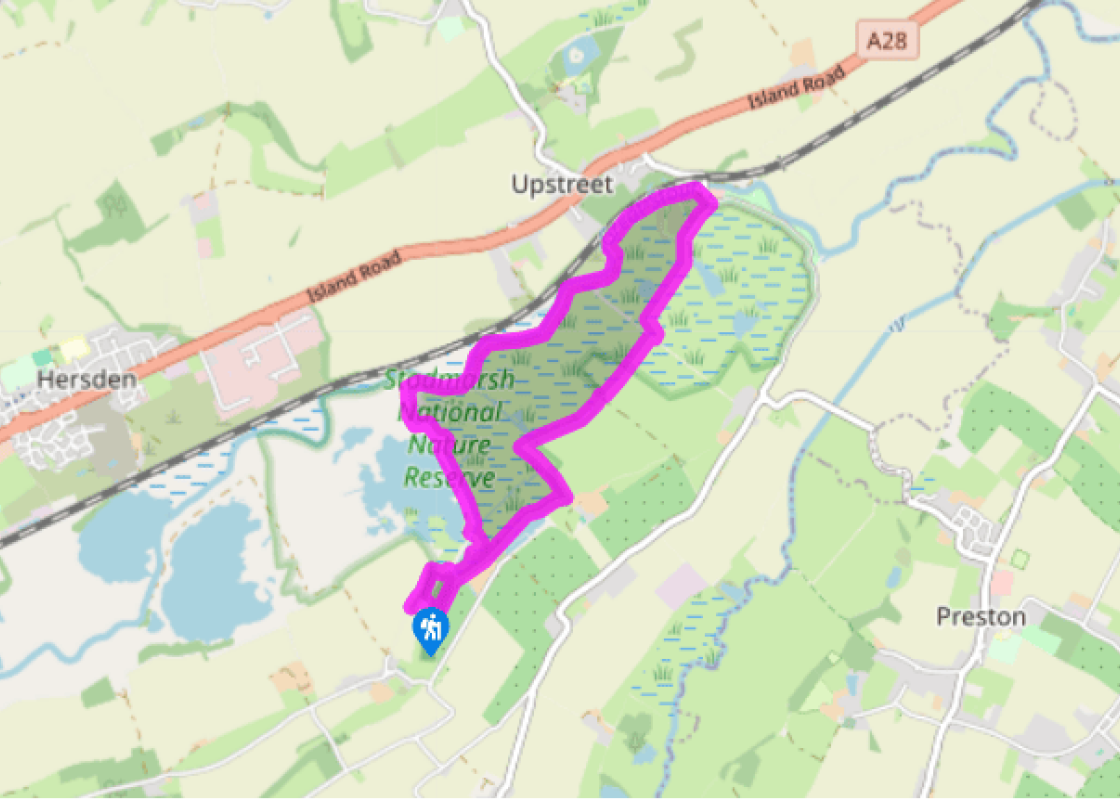
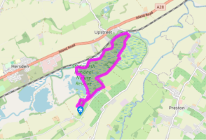
Park at the Nature Reserve’s car park near Stodmarsh village. An information board tells you about the site and its inhabitants. Now follow the signs for the nature trail, which at this point leads you through reed beds, which seem to rustle in the breeze. Cross the bridge over the stream, past benches and over another bridge. At the signpost, follow the nature trail again. The route now takes you over two more bridges and along a wide path to a walkway. Cross another bridge and walk to another path where you turn right to go along the old Lampen Wall.
Soon reach Lake Tower Hide, a large hide on stilts with a great view over the lake. The path now bears away from the lake and becomes a grassy track. Continue along this for about one mile (1.6km), with the Stour on your left, until you come to a gate that leads onto the road at Grove Ferry.
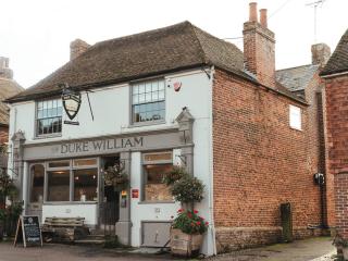
At the road is a pub, The Grove Ferry Inn, and a pick-up point for boat trips along the river. The fields bordering the river were once thickly carpeted with lavender bushes that were grown for commercial purposes. The fragrant flowers were cut by hand and then made into lavender water, which was highly sought after by wealthy people. The fields looked spectacular when the plants were in full bloom and people would come from miles around to admire them. Turn right along the road to where it bends sharp left, then follow the footpath right beside a gate and information board.
Walk ahead along the grassy path across the marshes, passing The Mound viewing point, where you have good views across the Wickhambreaux Valley. Keep to the grass track, pass a hide, then turn right at a junction of paths. In a few paces, turn left through a kissing gate and keep ahead. Cross a footbridge over a stream, ignore the footbridge on your left and continue through the nature reserve.
Pass Marsh Hide and follow the path left, soon to bear right at a footbridge. Pass a farm to your left, enter trees and turn left over a bridge to retrace your steps along the nature trail back to the car park.
Bring your binoculars for this walk as it takes you through Stodmarsh National Nature Reserve, one of England’s most diverse wetland habitats and a place that simply oozes with bird life. Hidden away in the Stour Valley, this tranquil reserve has several types of marshland, shallow lagoons and... grazing meadows. There are plenty of hides along the way, from where you can get a closer look. Come in the winter and you’ll see wildfowl, such as shoveler ducks, teal and mute swans. In the spring and autumn there are many migratory birds including reed and sedge warblers, lapwings and redshanks. Marsh harriers, ospreys, ruffs, siskins, stonechats and kingfishers have also been sighted. You might be lucky and see a bearded tit, a pretty little bird that clings to the stems of reeds and makes a distinctive ‘pinging’ call. Another bird that loves the reeds is the secretive bittern, a relative of the heron, and one of Britain’s most threatened species. You are unlikely to spot one, but you might hear its distinctive booming call. Although Stodmarsh is best known for its birds, it is also home to the water vole – ‘Ratty’ in The Wind in the Willows – a mammal which is in serious decline elsewhere. It might look as if this is a natural landscape; in fact it is entirely artificial. Early records show that monks from a nearby monastery once had a stud farm here (hence the name Stodmarsh – from the Anglo-Saxon stode (mare) and merse (marsh); essentially the stud in the marsh. They dug ditches in order to encourage flood water from the Stour on to the surrounding meadows where they grazed their horses. In the 17th century a flood defence barrier, the Lampen Wall, was built by Flemish refugees, allowing them access to the Wantsum marshes and draining the valley. However, when a coal mine opened here, the underground workings caused subsidence and the land became waterlogged. This was a blessing in disguise, as the 20th-century saw a dramatic decline in Britain’s wetlands, which in turn reduced the numbers of species dependent upon them. By the 1930s lagoons had appeared and reed beds began to grow. The colliery finally closed in 1968, leaving a precious wetland which was preserved for wildlife. To maintain this habitat and prevent these sites from reverting to scrub, the water levels in the reserve are controlled and the reed beds are managed by harvesting the reeds and grazing the surrounding meadow.
Kent is home to the White Cliffs of Dover, an English icon that marks the point where the Kent Downs AONB stretches from the Surrey Hills down to the sea. Visitors can explore historic parklands, including Knole Park and Sir Winston Churchill’s former home at Chartwell, or beautiful nature reserves, such as the coppiced woodlands of Denge Wood and Earley Wood and the ancient fine chalk woodland of Yockletts Bank.
Park at the Nature Reserve’s car park near Stodmarsh village. An information board tells you about the site and its inhabitants. Now follow the signs for the nature trail, which at this point leads you through reed beds, which seem to rustle in the breeze. Cross the bridge over the stream, past benches and over another bridge. At the signpost, follow the nature trail again. The route now takes you over two more bridges and along a wide path to a walkway. Cross another bridge and walk to another path where you turn right to go along the old Lampen Wall.
1 of 5
Soon reach Lake Tower Hide, a large hide on stilts with a great view over the lake. The path now bears away from the lake and becomes a grassy track. Continue along this for about one mile (1.6km), with the Stour on your left, until you come to a gate that leads onto the road at Grove Ferry.
2 of 5
At the road is a pub, The Grove Ferry Inn, and a pick-up point for boat trips along the river. The fields bordering the river were once thickly carpeted with lavender bushes that were grown for commercial purposes. The fragrant flowers were cut by hand and then made into lavender water, which was highly sought after by wealthy people. The fields looked spectacular when the plants were in full bloom and people would come from miles around to admire them. Turn right along the road to where it bends sharp left, then follow the footpath right beside a gate and information board.
3 of 5
Walk ahead along the grassy path across the marshes, passing The Mound viewing point, where you have good views across the Wickhambreaux Valley. Keep to the grass track, pass a hide, then turn right at a junction of paths. In a few paces, turn left through a kissing gate and keep ahead. Cross a footbridge over a stream, ignore the footbridge on your left and continue through the nature reserve.
4 of 5
Pass Marsh Hide and follow the path left, soon to bear right at a footbridge. Pass a farm to your left, enter trees and turn left over a bridge to retrace your steps along the nature trail back to the car park.
Bring your binoculars for this walk as it takes you through Stodmarsh National Nature Reserve, one of England’s most diverse wetland habitats and a place that simply oozes with bird life. Hidden away in the Stour Valley, this tranquil reserve has several types of marshland, shallow lagoons and... grazing meadows. There are plenty of hides along the way, from where you can get a closer look. Come in the winter and you’ll see wildfowl, such as shoveler ducks, teal and mute swans. In the spring and autumn there are many migratory birds including reed and sedge warblers, lapwings and redshanks. Marsh harriers, ospreys, ruffs, siskins, stonechats and kingfishers have also been sighted. You might be lucky and see a bearded tit, a pretty little bird that clings to the stems of reeds and makes a distinctive ‘pinging’ call. Another bird that loves the reeds is the secretive bittern, a relative of the heron, and one of Britain’s most threatened species. You are unlikely to spot one, but you might hear its distinctive booming call. Although Stodmarsh is best known for its birds, it is also home to the water vole – ‘Ratty’ in The Wind in the Willows – a mammal which is in serious decline elsewhere. It might look as if this is a natural landscape; in fact it is entirely artificial. Early records show that monks from a nearby monastery once had a stud farm here (hence the name Stodmarsh – from the Anglo-Saxon stode (mare) and merse (marsh); essentially the stud in the marsh. They dug ditches in order to encourage flood water from the Stour on to the surrounding meadows where they grazed their horses. In the 17th century a flood defence barrier, the Lampen Wall, was built by Flemish refugees, allowing them access to the Wantsum marshes and draining the valley. However, when a coal mine opened here, the underground workings caused subsidence and the land became waterlogged. This was a blessing in disguise, as the 20th-century saw a dramatic decline in Britain’s wetlands, which in turn reduced the numbers of species dependent upon them. By the 1930s lagoons had appeared and reed beds began to grow. The colliery finally closed in 1968, leaving a precious wetland which was preserved for wildlife. To maintain this habitat and prevent these sites from reverting to scrub, the water levels in the reserve are controlled and the reed beds are managed by harvesting the reeds and grazing the surrounding meadow.
Kent is home to the White Cliffs of Dover, an English icon that marks the point where the Kent Downs AONB stretches from the Surrey Hills down to the sea. Visitors can explore historic parklands, including Knole Park and Sir Winston Churchill’s former home at Chartwell, or beautiful nature reserves, such as the coppiced woodlands of Denge Wood and Earley Wood and the ancient fine chalk woodland of Yockletts Bank.