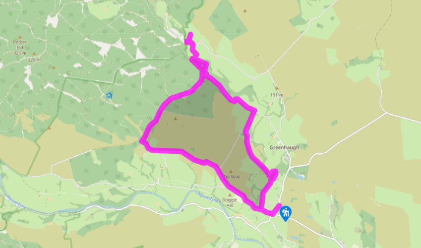
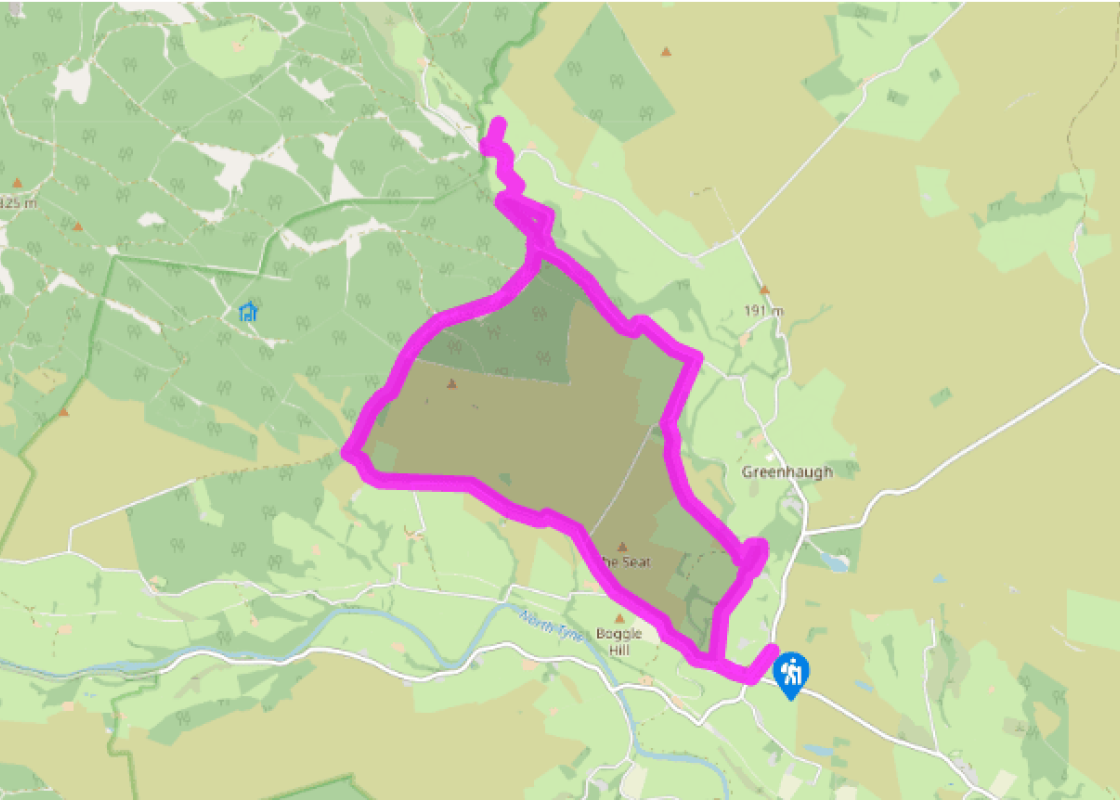
Walk downhill from the village hall to a road junction and go right. After 300yds (274m), turn right along a track beside Redmire Cottages. Keep ahead through the yard and across the field behind. Through a gap, continue to a hand gate, then bear left to another gate by Tarset Burn. Continue above the burn, eventually reaching a gated bridge. Cross and go right to a track. Follow it left up to Boughthill Farm.
Through the gated yard, climb away on a track. Where it shortly swings left, keep ahead at a waymarker, dropping steeply to cross a burn. Climb out to cross the meadow above, passing a waymarker to a gateway. Immediately beyond, go right to a hand gate then swing left beside a fence at the edge of open moor. Ignore a stile and continue to the fence corner. Swing half right, heading slightly west of north across open moor towards the corner of a distant wall that shortly comes into view. Drop beside it to a bridge.
Climb half left to a track at the top. Follow it left through a gate and on beside Thorneyburn churchyard. Emerging onto a narrow lane, turn right past the church. Reaching a T-junction go left, soon winding past Redheugh Farm, where a gate on the left leads to an 18th-century dovecote. The lane continues beyond the farm through forest to Sidwood Picnic Site.
Keep ahead, but, opposite a white house, turn off left on a path signed to an Iron Age hill-fort. Rising through the trees, it winds past a small pool before reaching the clearing of the settlement site. Keep ahead at its edge into trees beyond. Approaching a gully, wind right, dropping to a forest road. Cross to the path opposite, which winds down to Tarset Burn. Follow it right, cross a bridge and head away at the edge of meadow. Reaching trees, swing left and follow a developing grass track to a lane. To the left, it leads to a small car park below the ruin of Black Middens Bastle.
Return by the same route, but after crossing Tarset Burn, go left through a kissing gate. The path later turns from the stream and climbs to a track. Go left back to Sidwood.
Just past the house, turn off right on a bridlepath to Slaty Ford. A short distance along, watch for a waypost nudging the path right across a narrow burn. Swing left to climb beside it, eventually meeting a forest road. The path continues opposite across more open ground before rising back into trees. Later, cross another forest road, the gradient now easing over the watershed. Reaching the corner of a wall follow it on to a gate. Carry on ahead across bracken and heather moor, the path initially by the left wall, but shortly moving away on a parallel course above a developing fold on your left. The faint path eventually steepens to a tiny burn. Climb beyond to a rough track and follow it left through a gate to Slaty Ford.
After briefly sharing the stream's course, the track rises away. Follow it ahead across the hillside for 1.5 miles (2.4km), ultimately meeting the main lane. To the left, it eventually drops across Tarset Burn before rising back to Lanehead.
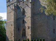
The area around Lanehead is called Tarset. The name means ‘the fold in the dry pine woods’ and is first recorded in the early 13th century. Although there is a Tarset Village Hall, there is in fact no Tarset village – only the burn, a parish name and the scant remains of Tarset Castle, south of... Lanehead. It was founded in 1267 by 'Red' John Comyn, a claimant to the Scottish throne who was stabbed at the altar of Greyfriars Church in Dumfries by Robert the Bruce in 1306. The castle was torched by the Scots in 1525 and the remains destroyed by the construction of a railway cutting in 1860. The walk first follows Tarset Burn before heading across moorland and through the fringes of Kielder Forest to visit the impressive remains of Black Middens Bastle. The fortified farmhouse comprised accommodation for livestock on the ground floor, with living quarters above, originally reached only by a ladder that could be drawn up, and offered some protection for the farmer and his family against marauding raiders. Shipshape religion The tiny hamlet of Thorneyburn mainly consists of the church and the large former rectory. Both were constructed in 1818 for trustees of Greenwich Hospital. It had been given the parish in 1735 after the former patron, the Catholic Earl of Derwentwater, had been disgraced for his part in the Old Pretender’s rebellion of 1715. The charity, established by William III in 1694 to look after naval veterans, still maintains an estate in north Northumberland, as well as its valuable landholdings in the capital. Like nearby Greystead, Wark and Humshaugh, Thorneyburn had a succession of naval chaplains as rector, and all four have very similar churches and rectories. The farmhouse at nearby Redheugh probably started life as a fortified bastle house; at the edge of the small field opposite is a pretty pyramid-roofed 18th-century dovecote. Disasters at Slaty Ford Sidwood Picnic Site is the start of a number of waymarked trails through this part of the huge Kielder Forest, including the ‘Reivers Trail’. As well as the ubiquitous pines, there are a number of ornamental trees that remain from the old Sidwood Estate. Through the woods and over the ridge is Slaty Ford – a peaceful place, but with a tragic history. In September 1796 six workers in the nearby colliery shaft were killed – either by an influx of water from a disused shaft or from an explosion; the records are unclear. On 20 September 1957 a Vickers Varsity aeroplane, on a training flight from RAF Thorney Island in Sussex, crashed here, killing all five crew members.
If it’s history you’re after, there’s heaps of it in Northumberland. On Hadrian’s Wall you can imagine scarlet-cloaked Roman legionaries keeping watch for painted Pictish warriors while cursing the English weather and dreaming of home.
Walk downhill from the village hall to a road junction and go right. After 300yds (274m), turn right along a track beside Redmire Cottages. Keep ahead through the yard and across the field behind. Through a gap, continue to a hand gate, then bear left to another gate by Tarset Burn. Continue above the burn, eventually reaching a gated bridge. Cross and go right to a track. Follow it left up to Boughthill Farm.
1 of 7
Through the gated yard, climb away on a track. Where it shortly swings left, keep ahead at a waymarker, dropping steeply to cross a burn. Climb out to cross the meadow above, passing a waymarker to a gateway. Immediately beyond, go right to a hand gate then swing left beside a fence at the edge of open moor. Ignore a stile and continue to the fence corner. Swing half right, heading slightly west of north across open moor towards the corner of a distant wall that shortly comes into view. Drop beside it to a bridge.
2 of 7
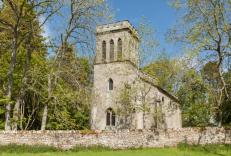
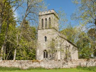
Climb half left to a track at the top. Follow it left through a gate and on beside Thorneyburn churchyard. Emerging onto a narrow lane, turn right past the church. Reaching a T-junction go left, soon winding past Redheugh Farm, where a gate on the left leads to an 18th-century dovecote. The lane continues beyond the farm through forest to Sidwood Picnic Site.
3 of 7
Keep ahead, but, opposite a white house, turn off left on a path signed to an Iron Age hill-fort. Rising through the trees, it winds past a small pool before reaching the clearing of the settlement site. Keep ahead at its edge into trees beyond. Approaching a gully, wind right, dropping to a forest road. Cross to the path opposite, which winds down to Tarset Burn. Follow it right, cross a bridge and head away at the edge of meadow. Reaching trees, swing left and follow a developing grass track to a lane. To the left, it leads to a small car park below the ruin of Black Middens Bastle.
4 of 7
Return by the same route, but after crossing Tarset Burn, go left through a kissing gate. The path later turns from the stream and climbs to a track. Go left back to Sidwood.
5 of 7
Just past the house, turn off right on a bridlepath to Slaty Ford. A short distance along, watch for a waypost nudging the path right across a narrow burn. Swing left to climb beside it, eventually meeting a forest road. The path continues opposite across more open ground before rising back into trees. Later, cross another forest road, the gradient now easing over the watershed. Reaching the corner of a wall follow it on to a gate. Carry on ahead across bracken and heather moor, the path initially by the left wall, but shortly moving away on a parallel course above a developing fold on your left. The faint path eventually steepens to a tiny burn. Climb beyond to a rough track and follow it left through a gate to Slaty Ford.
6 of 7
After briefly sharing the stream's course, the track rises away. Follow it ahead across the hillside for 1.5 miles (2.4km), ultimately meeting the main lane. To the left, it eventually drops across Tarset Burn before rising back to Lanehead.
The area around Lanehead is called Tarset. The name means ‘the fold in the dry pine woods’ and is first recorded in the early 13th century. Although there is a Tarset Village Hall, there is in fact no Tarset village – only the burn, a parish name and the scant remains of Tarset Castle, south of... Lanehead. It was founded in 1267 by 'Red' John Comyn, a claimant to the Scottish throne who was stabbed at the altar of Greyfriars Church in Dumfries by Robert the Bruce in 1306. The castle was torched by the Scots in 1525 and the remains destroyed by the construction of a railway cutting in 1860. The walk first follows Tarset Burn before heading across moorland and through the fringes of Kielder Forest to visit the impressive remains of Black Middens Bastle. The fortified farmhouse comprised accommodation for livestock on the ground floor, with living quarters above, originally reached only by a ladder that could be drawn up, and offered some protection for the farmer and his family against marauding raiders. Shipshape religion The tiny hamlet of Thorneyburn mainly consists of the church and the large former rectory. Both were constructed in 1818 for trustees of Greenwich Hospital. It had been given the parish in 1735 after the former patron, the Catholic Earl of Derwentwater, had been disgraced for his part in the Old Pretender’s rebellion of 1715. The charity, established by William III in 1694 to look after naval veterans, still maintains an estate in north Northumberland, as well as its valuable landholdings in the capital. Like nearby Greystead, Wark and Humshaugh, Thorneyburn had a succession of naval chaplains as rector, and all four have very similar churches and rectories. The farmhouse at nearby Redheugh probably started life as a fortified bastle house; at the edge of the small field opposite is a pretty pyramid-roofed 18th-century dovecote. Disasters at Slaty Ford Sidwood Picnic Site is the start of a number of waymarked trails through this part of the huge Kielder Forest, including the ‘Reivers Trail’. As well as the ubiquitous pines, there are a number of ornamental trees that remain from the old Sidwood Estate. Through the woods and over the ridge is Slaty Ford – a peaceful place, but with a tragic history. In September 1796 six workers in the nearby colliery shaft were killed – either by an influx of water from a disused shaft or from an explosion; the records are unclear. On 20 September 1957 a Vickers Varsity aeroplane, on a training flight from RAF Thorney Island in Sussex, crashed here, killing all five crew members.
If it’s history you’re after, there’s heaps of it in Northumberland. On Hadrian’s Wall you can imagine scarlet-cloaked Roman legionaries keeping watch for painted Pictish warriors while cursing the English weather and dreaming of home.