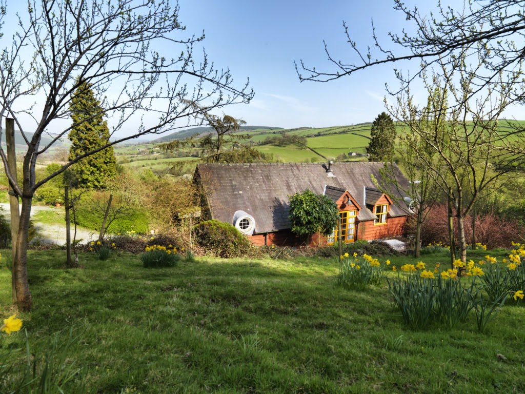


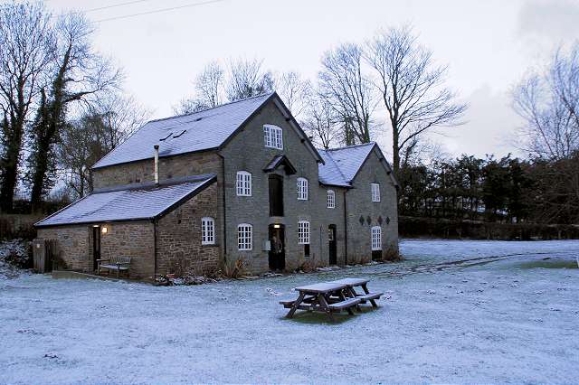
YHA Clun Mill
This beautifully restored water mill in the Shropshire village of Clun retains much of its…

Clun
5.5 miles (8.8kms)
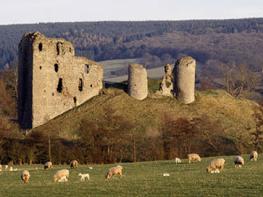
Clun is enfolded by enticing green hills on all sides. It may have been settled as early as the Bronze Age; certainly by the Iron Age there was some sort of community there. But it was the Saxons who first settled in any numbers. Later, the Norman Picot de Say built a castle here around 1099 and laid out a new town in a regular grid pattern, which still survives. Clun was granted its town charter in the 14th century and is still, strictly speaking, a town, but it looks and feels more like a village. There is lots to see, including the substantial castle ruins, 12th-century church, 15thcentury packhorse bridge, 17th-century almshouses, 18th-century town hall and many charming cottages.
Equally interesting, but not so well known, are the literary connections that abound in Clun. E M Forster visited the town, which subsequently featured as Oniton in Howard's End, published in 1910. One of his key characters, Margaret Schlegel, is totally captivated by the romance and magic of this corner of the Marches. The castle, with its great keep and commanding site, is said to have been the inspiration for Garde Doleureuse in Sir Walter Scott's novel The Betrothed, published jointly with The Talisman as Tales of the Crusaders in 1825. Scott is believed to have stayed at the Buffalo Inn while working on the book. More recently, playwright John Osborne lived near Clun and now lies buried in the churchyard. The best known literary link, however, is with A E Housman, the author of a timeless collection of poems called A Shropshire Lad. Housman famously described Clunton and Clunbury, Clungunford and Clun as 'the quietest places under the sun'.
Clun also featured in Valley With a Bright Cloud, a ghost story written by Gareth Lovatt Jones in 1980, while nearby Clunbury became the adopted home of Ida Gandy in 1930. A writer and the wife of a country doctor, Gandy set out in an old Baby Austin to see rural England. On arriving in Clunbury she was so captivated that she decided to stay. The family settled in the village and Ida continued to write, and to broadcast too, with most of her work inspired by Shropshire. Her most famous book is An Idler on the Shropshire Borders, written in 1970, around 25 years after the Gandys had left Shropshire for retirement in Dorset.
Walk down Hospital Lane to High Street and turn right to The Square. Pass the Buffalo Inn (closed at the time of writing), turn left on Buffalo Lane and cross Clun Bridge. Go up Church Street, turn right on the Knighton road, then left on Hand Causeway, signposted to Churchbank and Hobarris.
After 0.75 mile (1.2km), take a bridleway on the right, which leaves the lane on a bend by Glebe Cottage and immediately goes left into a field. Walk up the field, through a gate at the top, then straight on through two more fields to meet a lane running across the top of Clun Hill (part of the prehistoric Clun-Clee Ridgeway).
The path continues opposite, along the right-hand edges of two fields. At the end of the second one, go through a gate on the right and diagonally to the far corner of another field, then in much the same direction down the next.
Go through a gate and turn left on a byway, then right on a lane when you come to a T-junction. At Hobarris go left on to a track, just before the main farm buildings. Soon after crossing a brook, branch left along a hollow way. When this bends right, go straight on instead, over a stile into a field. Go straight uphill, joining a field-edge track. To your left, three Scots pines and a prehistoric cairn mark the summit of Pen-y-wern Hill. Turn left when you come to a lane.
At a crossroads, keep straight on, descending to the second of two bends in the lane. Ignore a signposted path on the right; instead take an unsignposted one a few paces further on. It leads into a plantation and soon bends right. About 200yds (183m) after this, branch left on a descending path.
After a further 100yds (91m) branch left again, descending through a beautiful oakwood, with scattered rowans and a ground cover of whinberries. Keep going down to meet a path at the bottom of the wood.
Turn left on the path, which almost immediately swings left, plunges back into the wood and winds through the trees to meet the lane. Turn right towards Clun.
Turn left at a junction with two tracks. Keep going along the lane until a stile on the right gives access to a field. Go diagonally left towards Clun. Join a lane, then turn right and cross a footbridge by a ford. Turn right to High Street and Hospital Lane.
Excellent, through mixed farmland (mainly pasture) and woodland
Steep-sided, round-topped hills above valley of River Clun
Keep under close control near sheep and cattle
OS Explorer 201 Knighton & Presteigne
Car park at Clun Memorial Hall, signed from High Street
At short-stay car park by castle and off High Street
Read our tips to look after yourself and the environment when following this walk.
Perhaps nowhere else in England will you find a county so deeply rural and with so much variety as Shropshire. Choose a clear day, climb to the top of The Wrekin, and look down on that ‘land of lost content’ so wistfully evoked by A E Housman. Peer through your binoculars and trace the course of Britain’s longest river as the Severn sweeps through the county, from the Breidden Hills to Wyre Forest, slicing Shropshire in two. To the north is a patchwork of dairy fields, hedgerows, copses and crops, broken at intervals by rugged sandstone ridges such as Grinshill or Nesscliffe, and dissected by a complex network of canals.
Spilling over the border into neighbouring Cheshire and North Wales is the unique meres and mosses country, with serenely smooth lakes glinting silver, interspersed with russet-tinged expanses of alder-fringed peat bog, where only the cry of the curlew disturbs the silence. South of the Severn lies the Shropshire Hills AONB. It’s only when you walk Wenlock Edge that you fully discover what a magical place it is – glorious woods and unexpectedly steep slopes plunge to innumerable secret valleys, meadows, streams and farmhouses, all tucked away, invisible from the outside world.
Discover more than 15,000 professionally rated places to stay, eat and visit from across the UK and Ireland.
Choose a place to stay safe in the knowledge that it has been expertly assessed by trained assessors.
Search by location or the type of place you're visiting to find your next ideal holiday experience.
Read our articles, city guides and recommended things to do for inspiration. We're here to help you explore the UK.