Coll Hotel
Coll Hotel is set in a remote and beautiful landscape that's well worth the journey. It sits…

A circuit of Iona to the marble quarry and the saint's landing place in Coracle Bay.
Iona
5.25 miles (8.4kms)
In the early summer of AD 563, a middle-aged cleric crossed over from Ireland with 12 companions and the intention of setting up a monastic community on the remote and windswept island of Iona.
Columba (in Gaelic, Colum Cille, 'the Dove of the Church') did not intend to bring Christianity to a new country, indeed he had left his native Ireland under a cloud. It had started with a dispute over copyright: Columba had secretly copied a psalter owned by St Finnian of Clonard, and Finnian had claimed ownership of the copy. The dispute became more complicated when a young prince accidentally killed an opponent during a game of Irish hockey and claimed sanctuary with Columba. A battle followed, for which Columba felt responsible. In penance for these events he accepted 'white martyrdom', perpetual exile.
At the centre of Columba's settlement on Iona was a church of oak logs and thatch and, around it, huts for the individual monks. Columba himself slept on the bedrock with a stone for a pillow. Larger huts of wattle were used as the dining hall, guest house, library and writing room. The monks' lives consisted of prayer, simple farming and study, and here Columba composed poetry in Latin and Irish.
Columba's Celtic Christianity spread from Iona across Scotland, and led to the Northumbrian foundation of Lindisfarne, with its rich tradition of illustrated documents such as the Lindisfarne Gospel. Here it came into contact with the Roman-style Christianity of continental Europe, brought to England by Augustine in AD 597. While the outward dispute was on the correct hairstyle for monks and the way to calculate the date of Easter, it seems that the Celtic Christianity was more personal and mystical, the Roman more authoritarian. The Roman version eventually dominated, but the Celtic was never suppressed. Columba, never officially canonised as a saint, is venerated in Scotland and Ireland to this day.
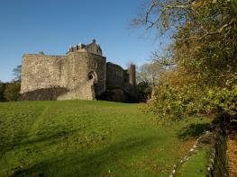
Columba's church vanished beneath a later Benedictine abbey, itself heavily restored in the 19th century. But the spirit of Columba still dominates the island. From the low hill called Dun I, on the day of his death, he blessed the island and community. The monks grew kale and oats at the machars (coastal lowlands) of Bay at the Back of the Ocean (Camus Cuil an t-Saimh), over what is today the golf course. At the southern tip of the island is Coracle Bay, traditionally named as the saint's landing place. 'That man is little to be envied, whose patriotism would not gain force upon the plain of Marathon, or whose piety would not grow warmer among the ruins of Iona,' said the renowned English writer and critic Samuel Johnson, who visited the island in 1773. Today's Iona Foundation is ecumenical – tied to no single denomination of Christianity – and has restored the buildings within a tradition of simple craftsmanship and prayer. The grave of John Smith, Labour leader in the 1990s, lies in the northeast extension of the burial ground.
Ferries cross to Iona about every hour. Once on the island, take the tarred road on the left, passing Martyr's Bay. After a second larger bay, the road bends right. Follow it across the island to a gate on to the Iona golf course (dogs on leads).
Take the sandy track ahead, then bear left in a slight dip to the shore. Turn left along the shore to a large beach. At its end, bear left up a narrow, sandy valley. After 100yds (91m) you pass a small concrete hut to join a stony track. It passes a fenced reservoir and drops to the corner of Loch Staoineig. Walk along to the left of the lochan on a well-built path, which runs gently down to Coracle Bay. You cross to the left of an area that shows the furrows of lazybed cultivation – fields drained to improve crop yields – and reach the shore just to the left of a rocky knoll.
The route ahead will follow an indistinct path. If your ferry to the mainland leaves in 2 hours time or earlier, return by the outward route and leave exploring the marble quarries for another visit. Otherwise, return inland for 200yds (183m) and turn right into a little grassy valley, passing a pointy rock. After 100yds (91m), go through a broken wall and then bear slightly left. A small path crosses heather to the eastern shoreline of the island. Bear left, above the small sea cliff, for 0.25 miles (400m). Turn sharp right into a little valley descending into the remnants of the marble quarry.
Turn inland, back up the valley and to the right of a low, ruined cottage. Follow the continuation valley to a waymarker post at its head. Continue in the same direction for about 300yds (274m) to a fence corner. Keep the fence on your left, picking a way on a patchy path through heather. Dun I with its cairn appears ahead – aim directly for it to reach the edge of fields, where a fence runs across ahead. Turn right along it to a small iron gate.
This leads to a track that passes Ruanaich farm to the tarred road of the outward walk. Cross on to a farm track, which bends to the right at Maol Farm. It reaches Baile Mor (Iona village) at the ruined nunnery. Just ahead is the abbey with its squat square tower, or turn right directly to return to the ferry pier.
Tracks, sandy paths, some rugged rock and heather
Bare gneiss rock and Atlantic Ocean
Keep on lead near sheep
OS Explorer 373 lona, Staffa & Ross of Mull
Ferry terminal at Fionnphort on Mull
Beside Martyr's Bay Bar
Read our tips to look after yourself and the environment when following this walk.
This is a county that’s all about awe-inspiring landscapes and unique island cultures. Ex-Beatle Paul McCartney put the area on the map when he wrote Mull of Kintyre, recorded in 1977 with the local pipe band backing his group. Kintyre is a long, thin peninsula that points south from the mainland, sheltering the mouth of the Firth of Clyde from the open sea. It’s very nearly an island, with just a narrow isthmus connecting it with Knapdale, to the north.
Tucked away at the end of the Firth of Clyde, Bute has been the holiday playground for generations of Glaswegians and is home to some of the finest golden beaches anywhere on the west coast. It may not boast the wild mountain grandeur of some of Scotland’s other islands, but Bute is blessed with swathes of heathery moorland and a range of low, fertile hills, perfect for walking and studying the local wildlife. Such is the variety of landscapes that make up this county.
To experience the sights and sounds of the area, visit Dunoon in late August for the Cowal Highland Gathering, when more than 150 pipe bands from all over the world compete for prestigious trophies.
Discover more than 15,000 professionally rated places to stay, eat and visit from across the UK and Ireland.
Choose a place to stay safe in the knowledge that it has been expertly assessed by trained assessors.
Search by location or the type of place you're visiting to find your next ideal holiday experience.
Read our articles, city guides and recommended things to do for inspiration. We're here to help you explore the UK.