
Trevalgan Touring Park
In an Area of Outstanding Natural Beauty and just two miles from St Ives, Trevalgan is an award-…

A varied walk along a spectacular coast and through ancient field systems.
Zennor
3.5 miles (5.6kms)
The Zennor area of west Cornwall is famous for a legend of a mermaid so enamoured with the singing of a local youth that she enticed him into the waters of nearby Pendour Cove. This walk takes you along the cliffs above the cove, where you should keep your eyes open for seals rather than mermaids. The real Zennor transcends this charming fantasy, not least because of the beauty of its location on a narrow coastal shelf between the Atlantic cliffs and the hills of the Land’s End Peninsula. Within the village itself are such features as the Church of St Senara, parts of which date from the Norman period and the 15th century. The church has a splendid three-stage tower that dominates the scene. The mermaid legend is given even greater prominence by a fine carved bench-end of the said charmer in all her glory.
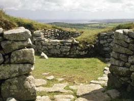
he narrow coastal shelf here is barely a mile (1.6km) wide. It represents a classic example of a wave-cut platform that once lay beneath the sea and was later left high and dry as sea levels fell. The hills above Zennor are studded with huge granite slabs and rocks, and in the small, flat fields around the village you can see the rounded tops of massive boulders protruding from the grass. The boundaries of these fields were first formed during the Iron Age, and the granite walls, or ‘hedges’ as they are called here, that still separate the fields today create a random web-like pattern that makes the area very distinctive. These Cornish hedges are made up of two walls of granite stones, with the space between filled with earth that supports an outer pelt of grass and vivid wild flowers. Somewhere beneath the coastal fields lies the boundary between the moorland granite and the more ancient rocks of the nearby coast, the greenstone and slate that make up the dramatic coal-black cliffs that rise for over 200ft (61m) from the restless sea.
The narrow lane that takes you down from Zennor village meets the coastal footpath. The first part of the walk circles Zennor Head, the most dramatic feature of this section of coast. There was mineral mining here during the 19th century, and mill wheels once ground corn beside the tumbling stream that falls into Pendour Cove, although few traces of these past industries survive today. From the high ground west of Pendour you can see the great cliffs of Zennor Head across the bay, their walls jet black in colour and mottled with patches of green lichen. The path wriggles its way along the cliff top to the lesser headland of Carnelloe, from where the walk leads inland and then back to Zennor along an ancient field path. This path is part of the ‘highway’ between farmsteads and hamlets once used by local people.
Turn left out of the car park, pass The Tinners’ Arms, then turn left again and bear round left down a lane behind the pub. Follow the lane for just over 0.5 miles (800m) to where it ends by an entrance to a house. Keep straight ahead along a narrow path for about 60yds (55m). Cross a stile onto a junction with the coast path beside a National Trust sign for Zennor Head.
Keep straight ahead along the coast path towards Zennor Head. Reach the summit of the Head, where there is a National Trust memorial plaque set into a large rock. Continue round to the right along the coast path, pass a cluster of large rocks, and then descend steeply.
Follow the path (it is close to the cliff edge in places, so take care) and climb steeply to a junction beside a small granite footpath sign. Turn right and follow a narrow path high above the sea and across the neck of Zennor Head. Turn left at a T-junction and retrace your earlier steps to where you joined the coast path at waypoint 2, by the National Trust sign for Zennor Head. Turn right and descend quite steeply and, just by a bench, descend steep steps (handrail). Descend a final flight of steps to a wooden bridge across a stream that gushes over boulders to Pendour Cove below.
Keeping left immediately at a fork, follow the rocky path steeply uphill, and pass a memorial seat. Continue uphill, ignoring a minor path going off right. The path levels off above Veor Cove.
Cross a stile and pass through a long stand of blackthorn bushes. Soon start to descend the northeast side of Carnelloe Headland. Follow the path round the base of the headland and turn steeply uphill. Turn left at a T-junction and signpost below a house, and climb steadily uphill. Follow the footpath behind the house to reach an open grassy area.
Join a wide grassy track and follow it inland, passing a mine wheel pit down the slope on the right. Reach a junction by a stream. Go through a kissing gate and keep left along a track.
Just before the main road, at Poniou, go left along a track in front of houses. Cross a bridge over a stream, and in about 30yds (27m), where the track veers sharp left, bear off it and cross a grid stile to the left of a field gate. Follow the left edge of a field and continue through several fields and over stiles.
Cross the final field and go over a stile and along a path between a hedge and a wire fence. Cross a final stile and follow a grassy track towards farm buildings. Turn right along a concrete track through Trewey Farm. At the main road turn left, with care, and in a few paces, at a junction, keep left and steeply downhill to return to the car park.
Occasionally rocky on coast path; some steep steps to descend (handrails); paths may be muddy; many stiles
Rugged coast and small fields below rocky moorland
Lead required through fields
OS Explorer 102 Land’s End
Zennor car park
None on route
Read our tips to look after yourself and the environment when following this walk.
Cornwall has just about everything – wild moorland landscapes, glorious river valley scenery, picturesque villages and miles of breathtaking coastline. With more than 80 surfing spots, there are plenty of sporting enthusiasts who also make their way here to enjoy wave-surfing, kite surfing and blokarting.
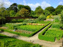
In recent years, new or restored visitor attractions have attracted even more visitors to the region; the Eden Project is famous for its giant geodesic domes housing exotic plants from different parts of the globe, while nearby the Lost Gardens of Heligan has impressive kitchen gardens and a wildlife hide.
Discover more than 15,000 professionally rated places to stay, eat and visit from across the UK and Ireland.
Choose a place to stay safe in the knowledge that it has been expertly assessed by trained assessors.
Search by location or the type of place you're visiting to find your next ideal holiday experience.
Read our articles, city guides and recommended things to do for inspiration. We're here to help you explore the UK.