


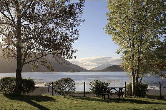
Invercoe Caravan & Camping Park
A level grass site set on the shore of Loch Leven, with excellent mountain views. The area is…

A sheltered forest ramble high above Loch Linnhe.
Inchree
2.75 miles (4.4kms)
Inchree is where General Wade's road from the Corran Ferry heads up into the hills on its way to Fort William. Today this slope, with its impressive set of waterfalls, is clothed in commercial plantations, but these are being allowed to revert to something slightly wilder.
The upper part of this walk follows the line of General Wade's road from the mid-18th century. It's hard to tell if any of the current path is original, as there’s really only one way to build a basic road without tarmac. The new path illustrates the Wade technique of jammed stones, covered with finer gravel. Where the path is carved into the hillside it shows the underlying rock to be lumpy white quartzite, the same rock that gives a whitish appearance to the tops of the hills above Glen Nevis. When the path itself was built, the big jammed stones were this same whitish quartzite while the overlying gravel was from several different quarries, in white but also in reddish granite.
Lower down, the walk features clearings left by windblown trees. In economic terms it makes sense to keep planting, even where there is a slight risk of losing trees in this way. Unusually stormy winters since 1999 have made trees more vulnerable than the planters of 30 years ago, before global warming, could have expected.
On the descent, a ravine on the left has been regenerating with a mixture of wild species and plantation escapees. The Sitka spruce is not native to Scotland, but the effect is pleasingly wild.
The slope above the forest road was clear-felled in 2002. A skyline cable was used to bring felled trees down the steep slope. This strong wire cable mounted on a standing tree trunk has to be high enough to keep the felled tree’s butt above the ground on the way down, but not so high that the leverage pulls the standing tree down. The felled tree is hauled downhill by an operator in a tractor on the forest road. If the haul-in cable should break, the suddenly released end is very dangerous, and so the tractor cab is armoured for protection. If the haul-back cable breaks, the felled tree starts coming very fast, and the operator has to drop the skyline quickly.
On a very steep slope like this one, the actual felling is the most skilled and demanding part of the job. Chainsaw operations are kept to a minimum – the trees are simply dropped to await the winch operation. Drop them wrong and they tangle up together, making the winch operation impossible. After clear-felling, this slope too has been left to its own devices with heather and self-sown spruce.
At the bottom corner of the car park is a well-built path marked by a blue-and-red waymarker. A field on its right gives views to hilltops beyond Loch Linnhe. The path crosses a footbridge to enter woodland before running gently uphill, through birchwoods with clearings of bracken and grass – these have views of Loch Linnhe itself. The Inchree waterfalls appear ahead, falling through a steep gorge lined with rhododendron. There are seven waterfalls, though only the top four are visible from here. They are particularly fine after heavy rain or during snowmelt. The path turns uphill, staying about 100yds (91m) from the falls, but with fine views of them, particularly from two viewpoint spurs on the right. Above the second viewpoint, the path bends left. Here you should ignore a small path running ahead through boggy ground. This is aiming for the top of the upper fall, but it isn’t recommended as the rocks alongside the fall are unsafe (wet quartzite is slippery) and you don’t actually get a better view of the water. Not far above, the main path runs up to a forest road.
Turn left along this. At a junction, the downward path, with red-and-green waymarkers, is a short-cut back to the car park. Your route turns uphill to the right, with a green waymarker. The wide path runs up under gloomy larches, with clearings formed by windblow. A stream runs up beside the track, which bends left to cross it. As it reaches younger trees above, it is running along the line of the old military road.
With a quarry on the left, the path reaches a forest track. Turn left, passing the quarry entrance, and in 100yds (91m) keep ahead as another forest track runs in from the right. Green waymarkers indicate the correct track. The wide, smooth road heads downhill, with a steep ravine down on its left, and views across Loch Linnhe ahead.
The forest road bends to the right, with trees on both sides: when they're next felled, this corner will again give a distant view of Inchree waterfalls. Turn down left on a steep path, which soon levels out to a footbridge. On reaching buildings, keep straight ahead under a narrow tree-belt to the car park.
Well-made paths, forest tracks
Plantation and semi-wild forest
Off lead in forest
OS Explorer 384 Glen Coe & Glen Etive
Forest Enterprise picnic place at road end, behind Inchree
Corran Ferry – bypass ferry queue and turn left into car park
<p> </p>
Read our tips to look after yourself and the environment when following this walk.
Apart from the Orkneys and the Shetlands, Highland is Scotland’s northernmost county. Probably its most famous feature is the mysterious and evocative Loch Ness, allegedly home to an ancient monster that has embedded itself in the world’s modern mythology, and the region’s tourist industry. Monster or no, Loch Ness is beautiful and it contains more water than all the lakes and reservoirs in England and Wales put together. The loch is 24 miles long, one mile wide and 750 feet deep, making it one of the largest bodies of fresh water in Europe.
At the very tip of the Highlands is John o’ Groats, said to be named after a Dutchman, Jan de Groot, who lived here in the early 16th century and operated a ferry service across the stormy Pentland Firth to Orkney. In fact, the real northernmost point of the British mainland is Dunnet Head, whose great cliffs rise imposingly above the Pentland Firth some two miles further north than John o’ Groats.
The Isle of Skye is the largest and best known of the Inner Hebrides. Its name is Norse, meaning ‘isle of clouds’, and the southwestern part of the island has some of the heaviest rainfall on the whole of the British coast. Despite this, it’s the most visited of all the islands of the Inner Hebrides. It’s dominated from every view by the high peaks of the Cuillins, which were only conquered towards the end of the 19th century.
Discover more than 15,000 professionally rated places to stay, eat and visit from across the UK and Ireland.
Choose a place to stay safe in the knowledge that it has been expertly assessed by trained assessors.
Search by location or the type of place you're visiting to find your next ideal holiday experience.
Read our articles, city guides and recommended things to do for inspiration. We're here to help you explore the UK.


