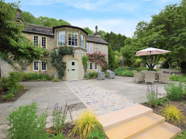

Churchdale Holidays
Churchdale Farm is a wonderful central Peak District holiday base, only two miles from Bakewell…

Enjoy sweeping views over the White Peak from a once-threatened limestone ridge near Great Longstone.
Longstone Edge
3.75 miles (6kms)
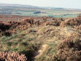
The gentle limestone scenery around the village of Great Longstone extends to the low, 3-mile (4.8km) ridge that dominates its northern horizon. Unlike the upland barriers further north and west, Longstone Edge presents a modest ripple and an inviting destination from which to look back and admire the glorious White Peak landscape that extends for many miles.
However, in recent years Longstone Edge has been under considerable threat and battles have been fought to preserve the very rock that makes up such a fine natural viewpoint. Huge chunks of the far eastern end of the hillside were eaten away by illegal quarrying, halted only after protracted legal action by the Peak District National Park Authority, supported by the local community. Licensed quarrying still continues on the Edge, but the scars will always remain as a reminder of the vulnerability of this supposedly protected landscape and the need for continued vigilance to protect it in the future.
Ironically, you can see virtually nothing of the quarrying from this walk on the southern side of Longstone Edge. There’s far more of immediate interest on the route up from Great Longstone, along a lovely walled track called Hardrake Lane. Halfway along, over the left-hand wall, are a couple of small dew ponds (you will also pass a larger one near the entrance to Stanshill Dale towards the end of the walk). Standing water has always been scarce on the porous limestone upland of the Peak District, so in the 18th and 19th centuries small circular, artificial ponds were dug in fields to collect rainwater and snow. They would be lined with clay to make them watertight, although concrete has been used in more modern versions. Contrary to their name, they had nothing to do with dew, since not enough would accumulate on even the most favourable nights. One theory is that the name originated from a Victorian pond-maker from southern England called Mr Dew. In this age of piped water and metal cattle troughs many dew ponds have disappeared, but efforts are being made to restore some of them, not least because they provide a valuable refuge for rare wildlife, like great created newts.
Once clear of the scrub-covered hillside, this walk satisfies itself with a good viewpoint above the road that climbs up from Great Longstone. Occasional trucks rumble along in the distance, serving the working quarry that still (legally) operates further along the edge. However, just over the fence to the north is a former quarry, now partly filled in and being restored to nature. It goes to show that over time some of the scars on this precious landscape can be healed.
From The White Lion pub on Great Longstone’s main street, walk up Church Lane opposite, taking the concessionary short-cut through the graveyard. About 150yds (137m) further on turn left into an unmade walled lane.
Immediately go right, through the squeeze stile in the wall, for a path slanting left across the end of the field. Turn right on to a walled path. Where this bends sharply left go straight on, through two fields, over a hard farm track, then across another field to reach a walled track at the bottom.
Turn left and follow this track, called Hardrake Lane, all the way up the shallow valley until it ends. Go through the wall gap and ahead and across a concrete farm track, through a gate and on for 100yds (91m) to a footpath sign. Turn left and head up across the open sloping field towards the scrub-covered edge.
Beyond a wooden barrier in the fence go straight on (not half left) up to steps in the wall. Go over and diagonally left for a path that slants gently up the scrubby and overgrown hillside. Ignore all paths off and stay on this route to emerge into the open. When you reach a junction with a vehicle track turn left for the upper one that continues to the top of the edge.
Go over the stile to the left of a metal gate, alongside the fence (ignoring another stile halfway along) to reach a lane. Go across the road and over the stile on the signposted public footpath to the very top of the edge. The path now drifts southwestwards and drops down through gorse to reach the lane once more. Turn right and follow the verge of this unfenced route all the way down until just before you reach a cattle grid, just before the bottom.
Turn left, back on yourself, for a path via a gate that goes out along the lower slopes of Longstone Edge. It becomes a wider track and very gradually climbs the hillside. Drop down to an old gate and just before this go hard right for a narrow slanting path below gorse bushes and down the hillside. At the bottom go over a stile and out across the middle of a huge field below to reach the gate on the far side.
Veer right into Stanshill Dale and follow the grassy path along the dale bottom. As it begins to level out make for the obvious gate in the wall above/right, then go half right through two more fields to reach the end of a long, unmade, walled lane. Go down this and at the end turn right to return to the centre of the village.
Grassy fields paths, farm tracks, surfaced lanes; several stiles
Undulating fields of pasture and scrub-covered limestone ridge
On lead around livestock but off lead on walled tracks
OS Explorer OL24 White Peak
Street-side in Great Longstone
None on route
Read our tips to look after yourself and the environment when following this walk.
The natural features of this central English county range from the modest heights of the Peak District National Park, where Kinder Scout stands at 2,088 ft (636 m), to the depths of its remarkable underground caverns, floodlit to reveal exquisite Blue John stone. Walkers and cyclists will enjoy the High Peak Trail which extends from the Derwent Valley to the limestone plateau near Buxton, and for many, the spectacular scenery is what draws them to the area.
The county is well endowed with stately homes – most notably Chatsworth, the palatial home of the Duke and Duchess of Devonshire, with its outstanding collections of paintings, statuary and art. Other gems include the well preserved medieval Haddon Hall, the Elizabethan Hardwick Hall, and Kedleston Hall, whose entrance front has been described as the grandest Palladian façade in Britain.
The spa town of Matlock is the county’s administrative centre and other major towns of interest include Derby and the old coal mining town of Chesterfield, with its crooked spire. Around the villages of Derbyshire, look out for the ancient tradition of well dressing, the decorating of springs and wells – the precious sources of life-sustaining water – with pictures formed from flowers.
Discover more than 15,000 professionally rated places to stay, eat and visit from across the UK and Ireland.
Choose a place to stay safe in the knowledge that it has been expertly assessed by trained assessors.
Search by location or the type of place you're visiting to find your next ideal holiday experience.
Read our articles, city guides and recommended things to do for inspiration. We're here to help you explore the UK.