"Walk around a once-prosperous moorland town that stood at the crossroads of history"
Walk directions
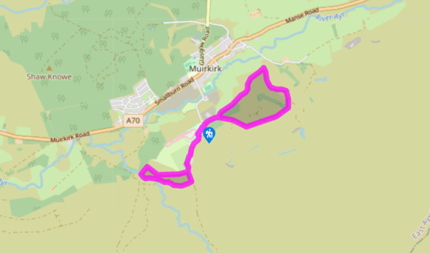
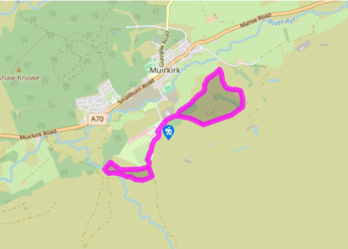
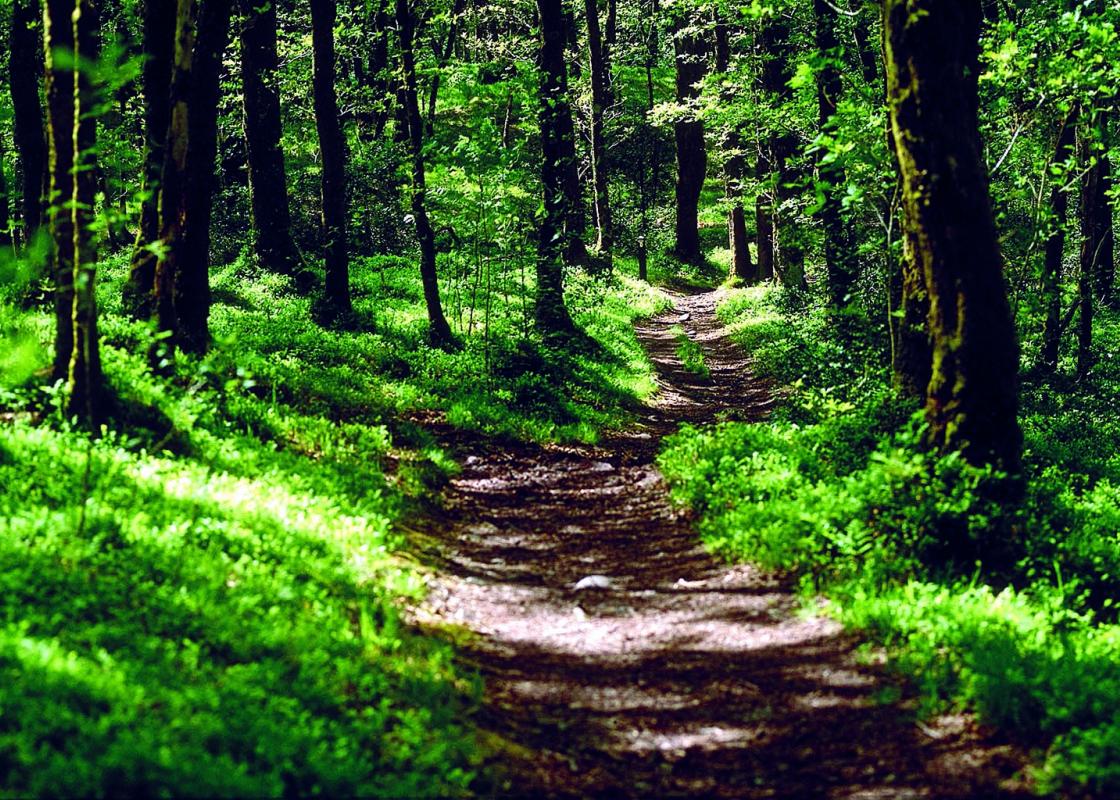
From the car park follow the blue waymarker and exit the car park via a gate on to a rough track with a high wall running along to the right. This continues as a fence and, once you are past the end of it, look out for a waymarker pole on your left.
Turn left on to a grass track. Follow this to some steps, go downhill and through a kissing gate. Turn right and walk along what may have been the bank of the 18th-century canal.
Go through several kissing gates, crossing a bridge over a burn and a gravel road between two gates. The path runs between two wire fences, along the trackbed, eventually reaching a kissing gate.
Go through the gate and turn right on to the quiet country road. Follow this past the remains of an old railway bridge, past a farm entrance on the right then go through a gate to continue on a farm road. At the next gate turn right, go through four gates and return to the car park.
Turn right and exit the car park on to Furnace Road, then turn left. Continue past the clock tower of the derelict Kames Institute and along the edge of a golf course. Go through a gate and continue, passing a cottage on the left, on to the old drove road to Sanquhar. Go through another gate and continue ahead to the McAdam memorial.
Just past this go through a gate and head along a green track on the right. Follow this track along the side of a stream until it joins a dirt track just above Tibbie's Brig. Near here, in a small clay dwelling, lived a local poetess, Tibbie Pagan, who eked out a living by singing, selling her poetry and possibly supplying illicit whisky. She is believed locally to have been the source of the song 'Ca the Yowes tae the Knowes', although Burns himself collected it from a clergyman. In 1803, she published a volume of her collected poems.
Go down to the Brig and the monument then return uphill keeping left on the access for the disabled route to McAdam's cairn. Follow this back to the drove road where you turn left to return to the car park.
In the early 17th century Muirkirk was not much more than a crude little settlement called Garan on a dirt track that ran from Ayr to Edinburgh. The building of the Moor Kirk of Kyle led eventually to a name change to Muirkirk. An abundance of natural minerals such as coal, limestone and iron ore... in the locality would inevitably make it a centre of industry and bring great prosperity. 'Tar' McAdam Coalmining was well under way when John Loudon McAdam (1756-1836) came here in 1786 to set up a tar works. Known locally as 'Tar' McAdam, he would later go on to develop his famous method of road construction and this is where he carried out his initial experiments. Furnace Road, leading to the walkers' car park, was used in his first trials and road surfaces are still referred to as 'tarmac' today. Iron and Coal Muirkirk became the site of Ayrshire's first ironworks in 1787 when James Ewing & Co opened here. Three years later a canal had been dug to transport ore and coal on a series of barges from the Lightshaw, Auldhouseburn and Crossflat mines east of the works. Tramlines ran to the west and a series of bogie tracks led from the various pits to the canals. The Kames Colliery was opened in 1799 and would become the longest operating coalmine in the area. The canal was eventually replaced by the railway when the Glasgow and South Western Railway Company opened the Auckinleck-to-Muirkirk branch line in 1848. From this main line a maze of spur lines ran to the production areas. Muirkirk became a prosperous, thriving community. It was the first town in Britain to get gas lighting following the construction of the Muirkirk Coke & Gaslight Co in 1859. At its peak, it had a population in excess of 5,000 with 1,000 employed in the ironworks alone. But nothing lasts forever. Mines become exhausted, or seams run out and industrial trends change. The ironworks ceased production in 1923, following a strike by the workers. Iron ore mining had stopped some time previously and the ore was shipped in from further afield. During the strike the furnaces cooled with iron still inside them and rather than go to the expense of restoring them the company shut down. The elaborate façade of the industrial works which locals had dubbed 'The Castle' was demolished in 1968, the same year that the Kames Colliery finally closed. By this time the railway had disappeared under the axe of Dr Beeching in the mid-1960s. With no industry left the population drifted away and Muirkirk gradually declined to the small, close-knit community that remains today.
Nestled between the Ayrshire coast, Dumfries & Galloway and South Lanarkshire, charming East Ayrshire encompasses the towns of Kilmarnock, Cumnock, New Cumnock and Stewarton. The county is home to a number of Sites of Special Scientific Interest (SSSI) in the form of lochs, glens rivers and uplands.
"Walk around a once-prosperous moorland town that stood at the crossroads of history"
Walk details
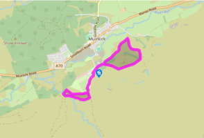
2hrs
Difficulty:
Easy
Gradient:
Moderate
Distance:
4.25 miles (6.8kms)
Ascent:
16ft (5m)
Walk directions
From the car park follow the blue waymarker and exit the car park via a gate on to a rough track with a high wall running along to the right. This continues as a fence and, once you are past the end of it, look out for a waymarker pole on your left.
1 of 7
Turn left on to a grass track. Follow this to some steps, go downhill and through a kissing gate. Turn right and walk along what may have been the bank of the 18th-century canal.
2 of 7
Go through several kissing gates, crossing a bridge over a burn and a gravel road between two gates. The path runs between two wire fences, along the trackbed, eventually reaching a kissing gate.
3 of 7
Go through the gate and turn right on to the quiet country road. Follow this past the remains of an old railway bridge, past a farm entrance on the right then go through a gate to continue on a farm road. At the next gate turn right, go through four gates and return to the car park.
4 of 7
Turn right and exit the car park on to Furnace Road, then turn left. Continue past the clock tower of the derelict Kames Institute and along the edge of a golf course. Go through a gate and continue, passing a cottage on the left, on to the old drove road to Sanquhar. Go through another gate and continue ahead to the McAdam memorial.
5 of 7
Just past this go through a gate and head along a green track on the right. Follow this track along the side of a stream until it joins a dirt track just above Tibbie's Brig. Near here, in a small clay dwelling, lived a local poetess, Tibbie Pagan, who eked out a living by singing, selling her poetry and possibly supplying illicit whisky. She is believed locally to have been the source of the song 'Ca the Yowes tae the Knowes', although Burns himself collected it from a clergyman. In 1803, she published a volume of her collected poems.
6 of 7
Go down to the Brig and the monument then return uphill keeping left on the access for the disabled route to McAdam's cairn. Follow this back to the drove road where you turn left to return to the car park.
In the early 17th century Muirkirk was not much more than a crude little settlement called Garan on a dirt track that ran from Ayr to Edinburgh. The building of the Moor Kirk of Kyle led eventually to a name change to Muirkirk. An abundance of natural minerals such as coal, limestone and iron ore... in the locality would inevitably make it a centre of industry and bring great prosperity. 'Tar' McAdam Coalmining was well under way when John Loudon McAdam (1756-1836) came here in 1786 to set up a tar works. Known locally as 'Tar' McAdam, he would later go on to develop his famous method of road construction and this is where he carried out his initial experiments. Furnace Road, leading to the walkers' car park, was used in his first trials and road surfaces are still referred to as 'tarmac' today. Iron and Coal Muirkirk became the site of Ayrshire's first ironworks in 1787 when James Ewing & Co opened here. Three years later a canal had been dug to transport ore and coal on a series of barges from the Lightshaw, Auldhouseburn and Crossflat mines east of the works. Tramlines ran to the west and a series of bogie tracks led from the various pits to the canals. The Kames Colliery was opened in 1799 and would become the longest operating coalmine in the area. The canal was eventually replaced by the railway when the Glasgow and South Western Railway Company opened the Auckinleck-to-Muirkirk branch line in 1848. From this main line a maze of spur lines ran to the production areas. Muirkirk became a prosperous, thriving community. It was the first town in Britain to get gas lighting following the construction of the Muirkirk Coke & Gaslight Co in 1859. At its peak, it had a population in excess of 5,000 with 1,000 employed in the ironworks alone. But nothing lasts forever. Mines become exhausted, or seams run out and industrial trends change. The ironworks ceased production in 1923, following a strike by the workers. Iron ore mining had stopped some time previously and the ore was shipped in from further afield. During the strike the furnaces cooled with iron still inside them and rather than go to the expense of restoring them the company shut down. The elaborate façade of the industrial works which locals had dubbed 'The Castle' was demolished in 1968, the same year that the Kames Colliery finally closed. By this time the railway had disappeared under the axe of Dr Beeching in the mid-1960s. With no industry left the population drifted away and Muirkirk gradually declined to the small, close-knit community that remains today.
Nestled between the Ayrshire coast, Dumfries & Galloway and South Lanarkshire, charming East Ayrshire encompasses the towns of Kilmarnock, Cumnock, New Cumnock and Stewarton. The county is home to a number of Sites of Special Scientific Interest (SSSI) in the form of lochs, glens rivers and uplands.