"A longer walk which climbs above the Crook O'Lune valley for a much wider view"
Walk directions
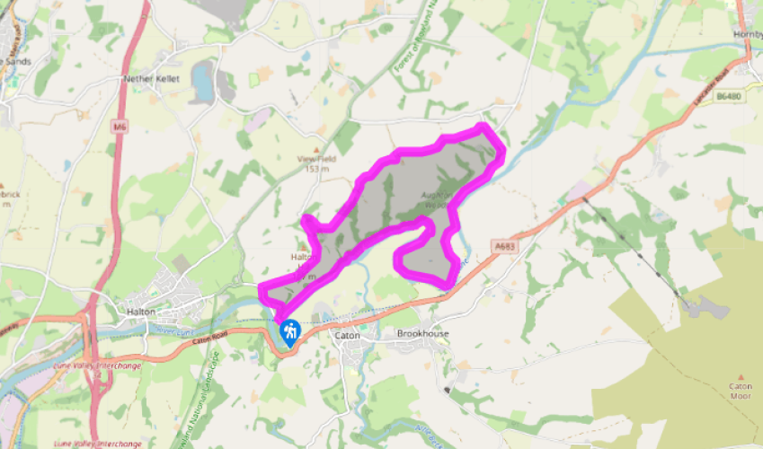
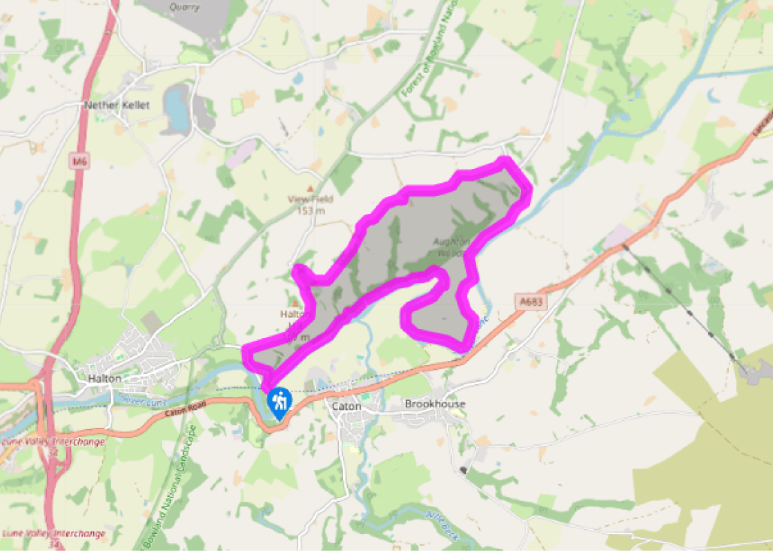
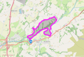
Leave the rear of the car park by the 'Artist's Easel'. Bear left through a gate and contour around a hill to meet a path beside the road. Go right to a junction and then right again to follow a lane across the open hillside.
After a mile (1.6km), turn off right along a track to Hawkshead Farm. Approaching the yard, leave left over a stile beside a barn. Skirt above the farm to another stile, over which you go left along the field top. Continue past the hedge corner to a wood. Carry on beyond up another field to Lower Highfield.
In the yard, bear right before a barn and pass through the left of two gates ahead. Follow the left boundary, swinging across the top of the field to a gate. Cut left to a ladder-stile and continue by a fence and high wall to Middle Highfield. Through a gate, bear right of the buildings to leave the field.
Go left and then right on a cobble path beside the old house. Cross a second track to a stile and keep ahead through a yard into a paddock. Walk to a stile in the far-left corner and carry on by a hedge, crossing from field to field over the hill to Far Highfield. Passing right of the buildings, cross a stile by the house. Bear right, passing a small hut and crossing a bridge to a stile. Maintaining the line, slant down the next field. Over a stile beside a gate, carry on past the end of trees to a stile onto a lane.
Walk downhill to Aughton and keep ahead at the junction, dropping steeply to Aughton Barns. Bend right past a cottage and follow the ongoing track across riverside meadows for 0.75 miles (1.2km). Rounding a bend, watch for a waypost in the left fence. Strike across the field, following an old riverbank that curves around to Over Lune Barn. Continue beside the river until it swings sharply left. Cross a gully and climb left to a stile into Burton Wood.
The path undulates across a steep bank above the river and demands care when wet. Further on, a concessionary path offers a longer loop through the wood, the two later rejoining. Leaving the trees, carry on past an aqueduct bridge and along a couple of riverside meadows. Beyond another wood, continue downstream, finally passing into more trees and rising to meet a cycle track. Double back right up to the car park.
The Lune valley below Sedburgh is called Lonsdale, not to be confused with Lunesdale, which is the upper reach footing the northern slopes of the Howgill Fells. Lonsdale is a delightful section where the hills step back behind a broad plain across which the river meanders back and forth, sometimes... even turning back on itself. The lazy river is prone to flooding and new channels can form as the river cuts through the loose silt and pebbles of the valley floor. The dale is characterised by long views, which stretch to the distant hills of the Yorkshire Dales and just a little height brings into view its famous three peaks, Pen-y-ghent, Ingleborough and Whernside. Distant views Beginning from the Crook O'Lune, where the river twists in an incredible 'U' bend that required the builders of the 'Little North Western Railway' to construct two separate bridges within the space of 250yds (229m), the walk climbs gently through parkland onto the northern heights above the valley. The way continues past a succession of farmsteads, all delighting in the name 'Highfield', through an interesting mix of woodland copses interspersing open grazing and meadows. There are superb views to the distant Yorkshire Dales and more immediately to the bulk of Caton Moor across the valley, an outlier of the Bowland Fells. A giant pudding The field path runs out above Aughton and drops through the village along a steep wooded clough to the flood plain below. Aughton itself is pretty enough but, lacking a pub, has little to distract the passer-by – unless it happens to be Pudding Festival Weekend. It was first held in 1782, when the village cooked a giant plum pudding to try out a new willow boiler. It's only held every 21 years, perhaps to allow waistlines to recover, which is just as well since the 1992 version weighed into the record books at around three tonnes. Although the 2013 creation was a mere one tonne, there was plenty of fun to be had in such local sports as duck herding and snail racing. Ancient woodland The meandering return largely follows the river, which at one point turns back on itself to run up the valley for more than 0.25 miles (400m). Beyond, the path clambers across the slope of Burton Wood, a fragment of ancient woodland that has probably only survived because the hillside is too steep to be used for anything else. With the bridge in sight marking the end of the walk, the final section is a relaxing stroll.
Lancashire was at the centre of the British cotton industry in the 19th century, which lead to the urbanization of great tracts of the area. The cotton boom came and went, but the industrial profile remains.
"A longer walk which climbs above the Crook O'Lune valley for a much wider view"
Walk details
3hrs
Difficulty:
Medium
Gradient:
Moderate
Distance:
7.5 miles (12.1kms)
Ascent:
640ft (195m)
Walk directions
Leave the rear of the car park by the 'Artist's Easel'. Bear left through a gate and contour around a hill to meet a path beside the road. Go right to a junction and then right again to follow a lane across the open hillside.
1 of 6
After a mile (1.6km), turn off right along a track to Hawkshead Farm. Approaching the yard, leave left over a stile beside a barn. Skirt above the farm to another stile, over which you go left along the field top. Continue past the hedge corner to a wood. Carry on beyond up another field to Lower Highfield.
2 of 6
In the yard, bear right before a barn and pass through the left of two gates ahead. Follow the left boundary, swinging across the top of the field to a gate. Cut left to a ladder-stile and continue by a fence and high wall to Middle Highfield. Through a gate, bear right of the buildings to leave the field.
3 of 6
Go left and then right on a cobble path beside the old house. Cross a second track to a stile and keep ahead through a yard into a paddock. Walk to a stile in the far-left corner and carry on by a hedge, crossing from field to field over the hill to Far Highfield. Passing right of the buildings, cross a stile by the house. Bear right, passing a small hut and crossing a bridge to a stile. Maintaining the line, slant down the next field. Over a stile beside a gate, carry on past the end of trees to a stile onto a lane.
4 of 6
Walk downhill to Aughton and keep ahead at the junction, dropping steeply to Aughton Barns. Bend right past a cottage and follow the ongoing track across riverside meadows for 0.75 miles (1.2km). Rounding a bend, watch for a waypost in the left fence. Strike across the field, following an old riverbank that curves around to Over Lune Barn. Continue beside the river until it swings sharply left. Cross a gully and climb left to a stile into Burton Wood.
5 of 6
The path undulates across a steep bank above the river and demands care when wet. Further on, a concessionary path offers a longer loop through the wood, the two later rejoining. Leaving the trees, carry on past an aqueduct bridge and along a couple of riverside meadows. Beyond another wood, continue downstream, finally passing into more trees and rising to meet a cycle track. Double back right up to the car park.
The Lune valley below Sedburgh is called Lonsdale, not to be confused with Lunesdale, which is the upper reach footing the northern slopes of the Howgill Fells. Lonsdale is a delightful section where the hills step back behind a broad plain across which the river meanders back and forth, sometimes... even turning back on itself. The lazy river is prone to flooding and new channels can form as the river cuts through the loose silt and pebbles of the valley floor. The dale is characterised by long views, which stretch to the distant hills of the Yorkshire Dales and just a little height brings into view its famous three peaks, Pen-y-ghent, Ingleborough and Whernside. Distant views Beginning from the Crook O'Lune, where the river twists in an incredible 'U' bend that required the builders of the 'Little North Western Railway' to construct two separate bridges within the space of 250yds (229m), the walk climbs gently through parkland onto the northern heights above the valley. The way continues past a succession of farmsteads, all delighting in the name 'Highfield', through an interesting mix of woodland copses interspersing open grazing and meadows. There are superb views to the distant Yorkshire Dales and more immediately to the bulk of Caton Moor across the valley, an outlier of the Bowland Fells. A giant pudding The field path runs out above Aughton and drops through the village along a steep wooded clough to the flood plain below. Aughton itself is pretty enough but, lacking a pub, has little to distract the passer-by – unless it happens to be Pudding Festival Weekend. It was first held in 1782, when the village cooked a giant plum pudding to try out a new willow boiler. It's only held every 21 years, perhaps to allow waistlines to recover, which is just as well since the 1992 version weighed into the record books at around three tonnes. Although the 2013 creation was a mere one tonne, there was plenty of fun to be had in such local sports as duck herding and snail racing. Ancient woodland The meandering return largely follows the river, which at one point turns back on itself to run up the valley for more than 0.25 miles (400m). Beyond, the path clambers across the slope of Burton Wood, a fragment of ancient woodland that has probably only survived because the hillside is too steep to be used for anything else. With the bridge in sight marking the end of the walk, the final section is a relaxing stroll.
Lancashire was at the centre of the British cotton industry in the 19th century, which lead to the urbanization of great tracts of the area. The cotton boom came and went, but the industrial profile remains.