"Spectacular escarpments above a wild and remote valley that shelters a touching memorial."
Walk directions
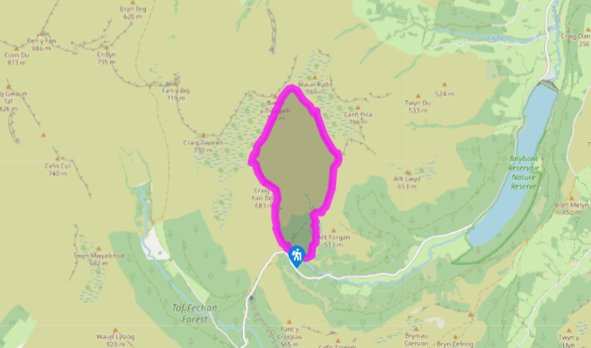
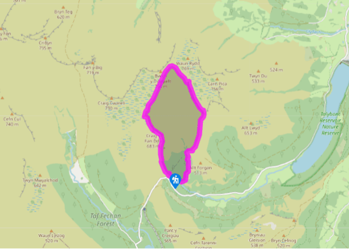
Walk back out of the car park, either crossing the cattle grid or a kissing gate to the left of it, then turn immediately right on to a stone track that heads uphill, with the stream on your left. Follow this track steeply up to the top of the escarpment and keep straight ahead to cross the narrow spur, where you bear around, slightly to the left, to follow the escarpment.
Stay on the clear path, with the escarpment to your right, for about 1.5 miles (2.4km), till you meet a number of paths at the head of the valley.
Take the sharp right turn to follow a narrow track slightly downwards, around the head of the valley, towards the cliffs that can be seen on the opposite hillside. Keep left at a fork and continue to the crash memorial.
Almost directly above the memorial, you’ll see a rocky gully leading up on to the ridge. On the left-hand side of this, as you look at it, is a faint track that climbs steeply up. Take this to the top and turn right on to a narrow but clear track. Follow this track easily above the crag, to a distinctive cairn at the southern end of the ridge. Just north of the cairn you’ll see a small stream.
Follow this down for 30ft (9m) to join a clear grassy track that trends leftwards at first, then follows a clear groove down the spur. This becomes an easy footpath that crosses a broad plateau and a bog and then leads to a junction at a wall. Turn right here and drop down to the Afon Caerfanell.
Cross the stile on your left at the bottom and follow the narrow footpath down-stream, past a number of waterfalls. Eventually you’ll pass the largest of them and come to a footbridge.
Cross the footbridge and go through a kissing gate to follow the track into the forest. Pass some ruined buildings on your right, and before you cross the small bridge, turn right on to a clear path that leads uphill into the forest with waterfalls on your left.
Continue uphill on the main track, crossing a stream and taking optional detours to the left and right to see other waterfalls. Eventually you’ll meet a broader forest track where you turn left and climb up to a gravel path where you turn left up to the car park.
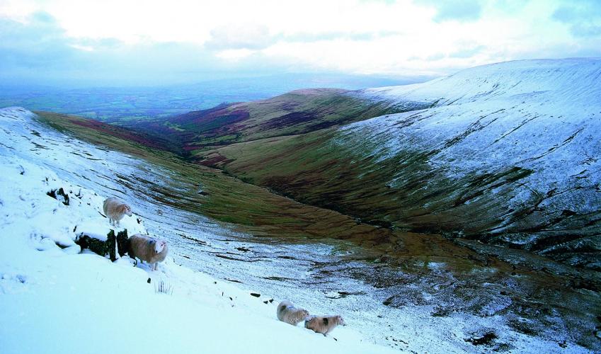
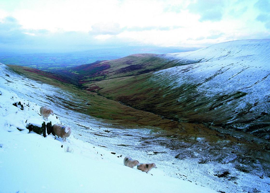
In only 5.5 miles (8.8km), this walk encapsulates almost every sort of landscape found in the National Park. It starts by climbing steeply on to an impressive peak from where you track easily along a steep sandstone escarpment, so typical of the area’s high mountain scenery. The airy path crosses... the head of a precipitous waterfall, rubs shoulders with an expansive moorland plateau and provides views that will remain in your memory for a long time. At the half-way stage, you’ll get a sneak peep of the highest peaks in the National Park as well as a bird’s-eye view over Cwm Oergwm, one of the most spectacular valleys in a wild land that’s famed for them. The return leg passes the forlorn wreckage of a Canadian warplane and a fitting memorial to those who perished in her, before dropping easily down to follow a delightful upland river past a series of tumbling waterfalls. It finishes with a steep pull up through a small plantation, with further cascades and rapids. As you approach the clearly visible cairn beneath Waun Rydd, a sharp eye will spot flashes of red, draped over the impeccable stonework. As you draw closer, you’ll see that the red is in fact, a plethora of poppy wreaths hung over a simple memorial. A bronze plaque lists the names of the young Canadians who lost their lives when Wellington bomber R1645 came down in bad weather, following a routine training flight on 6 July, 1942. The twisted wreckage, a deathly shade of dull grey, lies strewn around the bracken covered hillside below the cairn. The serenity and beauty of the Beacons’ landscape makes a fitting backdrop to the scene and it’s always difficult to pass this spot without pausing for reflection. Gigfran is Welsh for raven and the diminutive crag that shades the memorial is named after these powerful birds that can often be seen performing aerobatics above it. They are the largest members of the corvid family, easily distinguished from carrion crows, rooks, jackdaws and the rarer chough, by their size. Ravens are synonymous with remote upland areas and rugged coastal regions, where they tend to nest on crags and perform tumbling flight displays that appear more for pleasure than for purpose. Although the majority of their nourishment in the mountain environment comes from sheep carrion, they are endlessly resourceful and incredibly skillful hunters too.
The largest unitary authority in Wales, Powys covers an area of approximately 2,000 square miles. Much of that is mountainous because it actually has the lowest population density of all the Welsh counties.
"Spectacular escarpments above a wild and remote valley that shelters a touching memorial."
Walk details
3hrs 30min
Difficulty:
Medium
Gradient:
Challenging
Distance:
5.5 miles (8.8kms)
Ascent:
1542ft (470m)
Walk directions
Walk back out of the car park, either crossing the cattle grid or a kissing gate to the left of it, then turn immediately right on to a stone track that heads uphill, with the stream on your left. Follow this track steeply up to the top of the escarpment and keep straight ahead to cross the narrow spur, where you bear around, slightly to the left, to follow the escarpment.
1 of 8
Stay on the clear path, with the escarpment to your right, for about 1.5 miles (2.4km), till you meet a number of paths at the head of the valley.
2 of 8
Take the sharp right turn to follow a narrow track slightly downwards, around the head of the valley, towards the cliffs that can be seen on the opposite hillside. Keep left at a fork and continue to the crash memorial.
3 of 8
Almost directly above the memorial, you’ll see a rocky gully leading up on to the ridge. On the left-hand side of this, as you look at it, is a faint track that climbs steeply up. Take this to the top and turn right on to a narrow but clear track. Follow this track easily above the crag, to a distinctive cairn at the southern end of the ridge. Just north of the cairn you’ll see a small stream.
4 of 8
Follow this down for 30ft (9m) to join a clear grassy track that trends leftwards at first, then follows a clear groove down the spur. This becomes an easy footpath that crosses a broad plateau and a bog and then leads to a junction at a wall. Turn right here and drop down to the Afon Caerfanell.
5 of 8
Cross the stile on your left at the bottom and follow the narrow footpath down-stream, past a number of waterfalls. Eventually you’ll pass the largest of them and come to a footbridge.
6 of 8
Cross the footbridge and go through a kissing gate to follow the track into the forest. Pass some ruined buildings on your right, and before you cross the small bridge, turn right on to a clear path that leads uphill into the forest with waterfalls on your left.
7 of 8
Continue uphill on the main track, crossing a stream and taking optional detours to the left and right to see other waterfalls. Eventually you’ll meet a broader forest track where you turn left and climb up to a gravel path where you turn left up to the car park.
In only 5.5 miles (8.8km), this walk encapsulates almost every sort of landscape found in the National Park. It starts by climbing steeply on to an impressive peak from where you track easily along a steep sandstone escarpment, so typical of the area’s high mountain scenery. The airy path crosses... the head of a precipitous waterfall, rubs shoulders with an expansive moorland plateau and provides views that will remain in your memory for a long time. At the half-way stage, you’ll get a sneak peep of the highest peaks in the National Park as well as a bird’s-eye view over Cwm Oergwm, one of the most spectacular valleys in a wild land that’s famed for them. The return leg passes the forlorn wreckage of a Canadian warplane and a fitting memorial to those who perished in her, before dropping easily down to follow a delightful upland river past a series of tumbling waterfalls. It finishes with a steep pull up through a small plantation, with further cascades and rapids. As you approach the clearly visible cairn beneath Waun Rydd, a sharp eye will spot flashes of red, draped over the impeccable stonework. As you draw closer, you’ll see that the red is in fact, a plethora of poppy wreaths hung over a simple memorial. A bronze plaque lists the names of the young Canadians who lost their lives when Wellington bomber R1645 came down in bad weather, following a routine training flight on 6 July, 1942. The twisted wreckage, a deathly shade of dull grey, lies strewn around the bracken covered hillside below the cairn. The serenity and beauty of the Beacons’ landscape makes a fitting backdrop to the scene and it’s always difficult to pass this spot without pausing for reflection. Gigfran is Welsh for raven and the diminutive crag that shades the memorial is named after these powerful birds that can often be seen performing aerobatics above it. They are the largest members of the corvid family, easily distinguished from carrion crows, rooks, jackdaws and the rarer chough, by their size. Ravens are synonymous with remote upland areas and rugged coastal regions, where they tend to nest on crags and perform tumbling flight displays that appear more for pleasure than for purpose. Although the majority of their nourishment in the mountain environment comes from sheep carrion, they are endlessly resourceful and incredibly skillful hunters too.
The largest unitary authority in Wales, Powys covers an area of approximately 2,000 square miles. Much of that is mountainous because it actually has the lowest population density of all the Welsh counties.