Around Druridge Bay

NEAREST LOCATION

Druridge Bay

RECOMMENDED BY
DISTANCE

6.5 miles (10.4kms)

ASCENT
120ft (37m)
TIME
2hrs 15min
GRADIENT
DIFFICULTY
Easy
STARTING POINT
NU282024

About the walk

The story of Druridge Bay's pools begins 300 million years ago, when the area basked in a warm climate and was cloaked in a dense forest swamp. The gradual accumulation of decaying vegetation eventually gave rise to extensive coal deposits, which today extend far out to sea. Although coal was dug from shallow drifts or bell pits since the medieval period, it was only during the Industrial Revolution that mining began in earnest. Pits were sunk ever deeper, and mining developed as a major industry along the northeast coast, with villages such as nearby Broomhill springing up to house miners and their families.

Opencast mining

As the 20th century progressed, many pits became worked out or uneconomic, yet with the onset of World War II, the need for coal had never been greater. A new approach was tried, with the country's first opencast operation beginning on Town Moor, near Newcastle. Cheaper and simpler than deep mining, the scale of opencast workings increased, as the equipment needed to excavate and move immense quantities of rock was improved.

Work began on the Radcliffe site in September 1971, and a staggering 100 million tons of overlying rock was removed to extract some 2.5 million tons of coal. Within seven years all the coal was out, leaving behind a crater 170ft (52m) deep. The Northumberland Wildlife Trust bought part of the site in 1983 and has turned the derelict wasteland into the nature-rich lakes and islands we see today.

Nature reserves

Hauxley Pool is typical of the several flooded workings along the coast, and although huge numbers of trees, shrubs and other plants were originally brought in, there is now a remarkably natural feel to the water and its surroundings. As the fertility of the once-barren land has been improved, many species have become established on the banks, and in spring and summer the place is alive with colour from bloody cranesbill, yellow wort, kidney vetch and a host of other flowers. Look carefully and you'll spot the delicate pink petals of ragged robin, a rare sight in today's countryside.

The attraction for many visitors, however, is the variety and numbers of birds that visit these coastal lakes, a spectacle that is ever-changing throughout the year. Resident populations are joined by those migrating between the summer feeding and breeding grounds in the far north and the warmer climes of Africa, where many spend the winter. Dunlin, whimbrel and sanderling are amongst the many species passing through, while redshank, plover and bar-tailed godwit are some that winter here. You will also see whooper and Bewick swans as well as many favourites such as tits, finches, blackbirds and robins.

Walk directions

A waymarked footpath beside the Rangers' office winds into the nature reserve, where several hides overlook the lake. Swing left towards the coast, shortly rounding a bend to a junction. Go left, leaving the reserve through a gate onto a crossing track. 

Turn right. Within 200yds (183m), as a wooden lookout post comes into view over to the left, watch for a path leaving through the dunes. Drop to the shore and follow it south past the rocky carrs of the point and on along a vast sweep of open beach.

After 1.75 miles (2.8km), wooden steps take the path off the sands onto the dunes. Cross a tarmac lane and continue beside a marshy area into woodland. Keep ahead, crossing a drive and the main car park to the Druridge Bay Country Park Visitor Centre, where there is a cafe and toilets.

Walk down to the lake and follow a path around the shore to the left. Pass a car park and launching slipway, later reaching stepping-stones across the head of the lake. You can cross here or alternatively, turn left and then right on a path skirting a small nature sanctuary. Keep right at the next two junctions to cross a footbridge over the stream feeding the lake. Swing right through a gateway and follow the stream back to the stepping-stones.

This side of the lake has a more ‘natural’ feel, the path winding through trees to emerge beside a lushly vegetated shoreline where swans like to feed. After crossing a bridge over the lake’s outflow, carry on back to the visitor centre.

Retrace your steps to Hauxley, using the lookout post as your marker for leaving the beach. The cist and burial remains displayed in the country park's visitor centre were discovered near by in the dunes overlooking the southern edge of Bondi Carrs. The site was discovered in 1983, when coastal erosion exposed the first cist. Subsequent archaeological excavations have shown it to be part of a Bronze Age cemetery, beneath which is evidence of Mesolithic occupation dating back 7,000 years. Unfortunately, unless excavations are under way, there is nothing to see at the site.

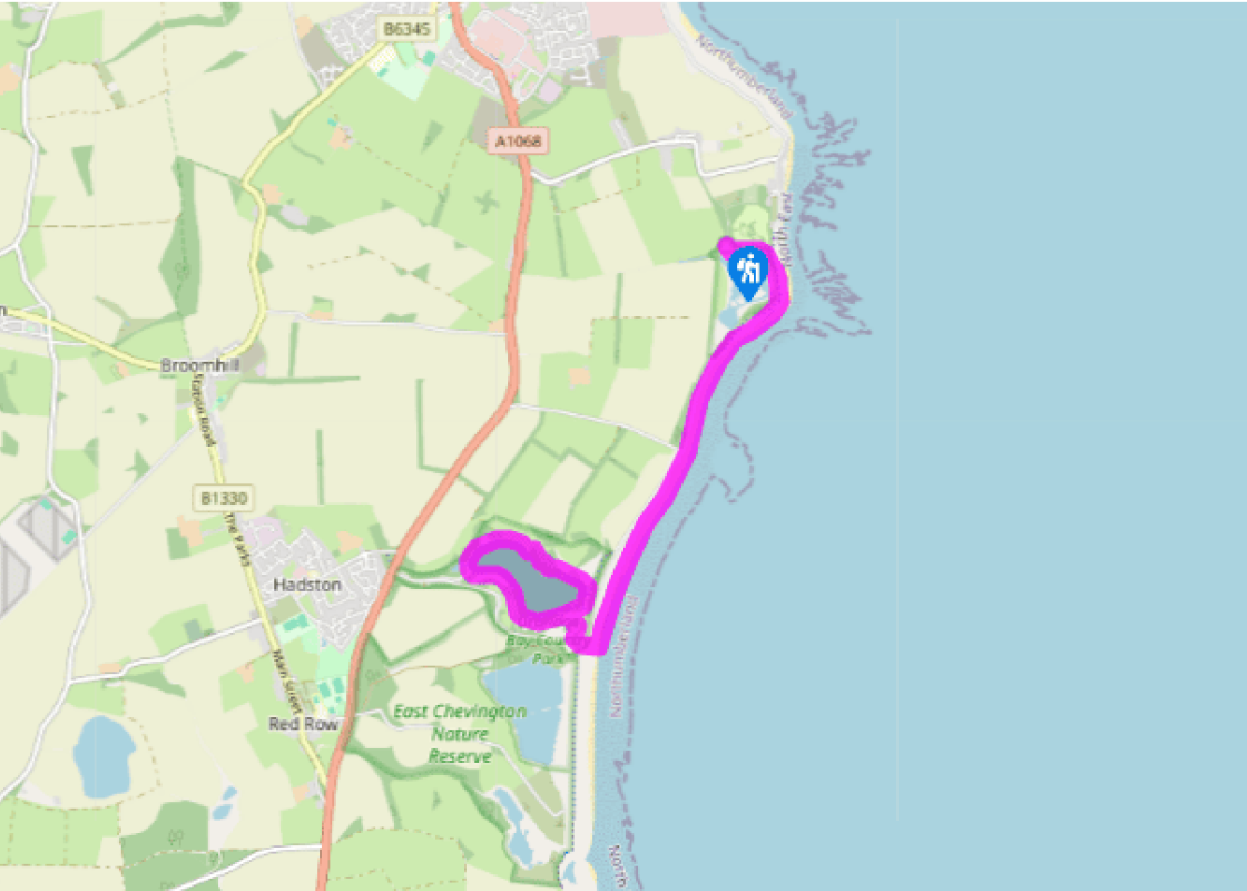
Additional information
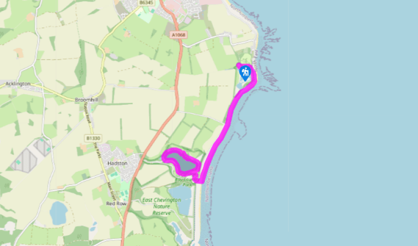
Paths and tracks, with good walk on beach, no stiles

Dunes, seashore and lakeside

On lead within nature reserve

OS Explorers 325 Morpeth & Blyth; 332 Alnwick & Amble

Car park at Hauxley Nature Reserve

Druridge Bay Country Park Visitor Centre

<p>Check tides; beach not always passable at high water but parallel lane offers an alternative.</p>

Been on this walk?

Send us photos or a comment about this route.

Know a good walk?

Share your route with us.

WALKING IN SAFETY

Read our tips to look after yourself and the environment when following this walk.

Find out more

About the area

Discover Northumberland

If it’s history you’re after, there’s heaps of it in Northumberland. On Hadrian’s Wall you can imagine scarlet-cloaked Roman legionaries keeping watch for painted Pictish warriors while cursing the English weather and dreaming of home. Desolate battlefield sites and hulking fortresses such as Alnwick, Dunstanburgh, Bamburgh and Warkworth are reminders that this, until not so very long ago, was a contested border region. The ruins of Lindisfarne bear witness to the region’s early Christian history.

Northumberland also has some of Britain’s best beaches. On summer days, and even in winter, you’ll see surfers and other brave souls making the most of the coast. Inland, there are some great walks and bike rides in the dales of the Cheviot Hills and the Simonsides – just hilly enough to be interesting, without being brutally steep. There's dramatic scenery in the High Pennines, where waterfalls plunge into deep valleys, and there are swathes of heather-scented moorland. Northumberland National Park covers over 400 square miles of moorland and valleys with clear streams and pretty, stone-built villages. It’s just the place for wildlife watching too. You’ll find flocks of puffins, guillemots and other seabirds around the Farne Islands, and seals and dolphins offshore.

Why choose Rated Trips?

Your trusted guide to rated places across the UK
icon example
The best coverage

Discover more than 15,000 professionally rated places to stay, eat and visit from across the UK and Ireland.

icon example
Quality assured

Choose a place to stay safe in the knowledge that it has been expertly assessed by trained assessors.

icon example
Plan your next trip

Search by location or the type of place you're visiting to find your next ideal holiday experience.

icon example
Travel inspiration

Read our articles, city guides and recommended things to do for inspiration. We're here to help you explore the UK.