"A tour of the cliff tops and beaches in the Pembrokeshire Coast National Park."
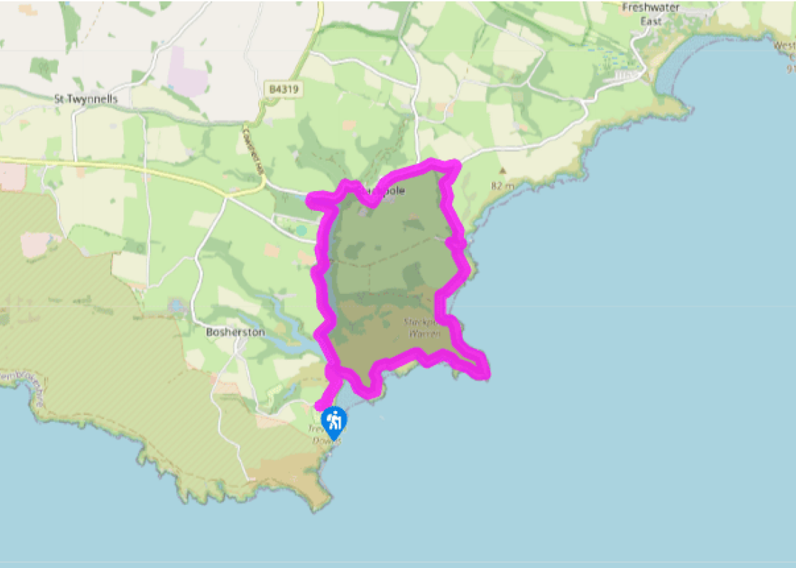
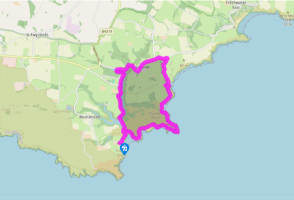
Walk directions
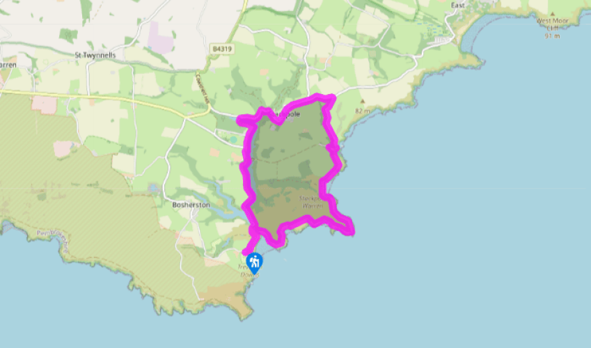
From the car park, head back to the National Trust building at the head of the lane and bear right, down a tarmac path and a set of steps, to the beach. Cross the beach and keep left to walk up the creek to a footbridge.
Go over the footbridge and turn left then shortly afterwards turn right at a fingerpost marked Stackpole Quay. Walk above rocky outcrops, above the beach, to a gate. Follow the grassy path around the headland and back inland to a gate above Saddle Bay. Continue around a large blowhole and up to a gate above a deeply cloven zawn (inlet), known as the Raming Hole.
Go through a gate a few hundred yards later and hug the coastline on your right to walk around Stackpole Head. As you turn back inland, pass a blowhole and then go through a gate to drop down to Barafundle Bay. Cross the back of the beach and climb up the steps on the other side to an archway in the wall. Continue through a gate and down some steps to Stackpole Quay.
Turn left, above the tiny harbour, and drop to pass the Boathouse Café on your left before turning sharp right on to a road. Follow this past some buildings on the right and up to a T-junction, where you turn left.
From here to Point 6 there is no pavement so care should be taken as vehicles can approach quickly along this section of winding road. Drop down into Stackpole village, pass the Stackpole Inn on the right, and continue around a series of bends until you come to a road on the left, over a bridge.
Cross the bridge and turn left to follow a good path along the side of the lake. Continue along this, ignoring a path off to the right, and turn left at a T-junction next to a building. Carry on along the lakeside to a bridge.
Don’t cross the bridge, but drop down on to a narrow path that keeps straight ahead and follow it with the lake on your left. Continue ahead to another bridge, cross it, then carry on with the lake now on your right. This path leads to the footbridge that you crossed at Point 2. Retrace your steps across the beach and up the steps back to the car park.
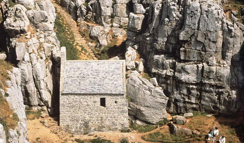
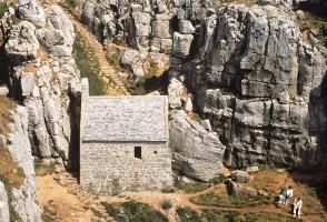
The limestone headlands of St Govan’s and Stackpole make up some of the most impressive coastline in south Pembrokeshire. Their grass-covered, plateau-like tops are very different to the relentlessly undulating ground covered by most of the coast path and, as a result, an excursion around this most... southerly point of Pembrokeshire is surprisingly relaxing. The cliffs, however, make up only a short section of a varied walk that crosses two of the region’s finest beaches and also explores some beautiful inland waters. Broad Haven is often referred to as Broad Haven South, to avoid confusion with the town and beach of the same name in St Brides Bay. The beach here is a broad gem of white sand, backed by rolling dunes and flanked by impressive headlands. Barafundle Bay is equally as picturesque, but also benefits from a lack of road access that keeps it relatively quiet for most of the year. The final attraction of this simple circuit is the three-fingered waterway that probes deeply inland from Broad Haven. The wooded shores and mirror-calm waters make a refreshing change and a lovely contrast to the wildness of the coast. The cliffs between Linney Head, closed to the public as part of the MOD firing range, and Stackpole Head, which is visited on this walk, are made up of carboniferous limestone and comprise some of the best limestone coastal scenery in Britain. Exposed to the full force of the Atlantic at their feet, they are often overhanging and also contain many caves and blowholes. A few spectacular sea stacks have survived the battering and now stud the coast a short distance offshore – Church Rock, seen on this walk, just off Broad Haven Beach, is one of the finest examples. The area is also one of the most popular rock climbing locations in the country. This series of interconnecting lakes was created at the turn of the 19th-century by Baron Cawdor, once the owner of the Stackpole Estate. He dammed a small tidal creek, which then flooded the three tributary valleys. Subsequent drifting of sand has created a large marram grass-covered dune system behind the beach. The lakes are rich in wildlife, with herons prowling the shallows, swans, ducks, moorhens and coots all visible on the surface, and shyer creatures such as kingfishers often spotted. The Lily Ponds are managed as a National Nature Reserve, and the lilies themselves are at their best in June, while the woodland is a magnificent spectacle in spring and autumn.
Wales meets the Atlantic Ocean in spectacular fashion at Pembrokeshire. Unlike the West Country, Pembrokeshire can offer the coast without the crowds, and quaint fishing villages without those huge coach parks.
"A tour of the cliff tops and beaches in the Pembrokeshire Coast National Park."
Walk details
2hrs 30min
Difficulty:
Easy
Gradient:
Gentle
Distance:
6 miles (9.7kms)
Ascent:
390ft (119m)
Walk directions
From the car park, head back to the National Trust building at the head of the lane and bear right, down a tarmac path and a set of steps, to the beach. Cross the beach and keep left to walk up the creek to a footbridge.
1 of 7
Go over the footbridge and turn left then shortly afterwards turn right at a fingerpost marked Stackpole Quay. Walk above rocky outcrops, above the beach, to a gate. Follow the grassy path around the headland and back inland to a gate above Saddle Bay. Continue around a large blowhole and up to a gate above a deeply cloven zawn (inlet), known as the Raming Hole.
2 of 7
Go through a gate a few hundred yards later and hug the coastline on your right to walk around Stackpole Head. As you turn back inland, pass a blowhole and then go through a gate to drop down to Barafundle Bay. Cross the back of the beach and climb up the steps on the other side to an archway in the wall. Continue through a gate and down some steps to Stackpole Quay.
3 of 7
Turn left, above the tiny harbour, and drop to pass the Boathouse Café on your left before turning sharp right on to a road. Follow this past some buildings on the right and up to a T-junction, where you turn left.
4 of 7
From here to Point 6 there is no pavement so care should be taken as vehicles can approach quickly along this section of winding road. Drop down into Stackpole village, pass the Stackpole Inn on the right, and continue around a series of bends until you come to a road on the left, over a bridge.
5 of 7
Cross the bridge and turn left to follow a good path along the side of the lake. Continue along this, ignoring a path off to the right, and turn left at a T-junction next to a building. Carry on along the lakeside to a bridge.
6 of 7
Don’t cross the bridge, but drop down on to a narrow path that keeps straight ahead and follow it with the lake on your left. Continue ahead to another bridge, cross it, then carry on with the lake now on your right. This path leads to the footbridge that you crossed at Point 2. Retrace your steps across the beach and up the steps back to the car park.
The limestone headlands of St Govan’s and Stackpole make up some of the most impressive coastline in south Pembrokeshire. Their grass-covered, plateau-like tops are very different to the relentlessly undulating ground covered by most of the coast path and, as a result, an excursion around this most... southerly point of Pembrokeshire is surprisingly relaxing. The cliffs, however, make up only a short section of a varied walk that crosses two of the region’s finest beaches and also explores some beautiful inland waters. Broad Haven is often referred to as Broad Haven South, to avoid confusion with the town and beach of the same name in St Brides Bay. The beach here is a broad gem of white sand, backed by rolling dunes and flanked by impressive headlands. Barafundle Bay is equally as picturesque, but also benefits from a lack of road access that keeps it relatively quiet for most of the year. The final attraction of this simple circuit is the three-fingered waterway that probes deeply inland from Broad Haven. The wooded shores and mirror-calm waters make a refreshing change and a lovely contrast to the wildness of the coast. The cliffs between Linney Head, closed to the public as part of the MOD firing range, and Stackpole Head, which is visited on this walk, are made up of carboniferous limestone and comprise some of the best limestone coastal scenery in Britain. Exposed to the full force of the Atlantic at their feet, they are often overhanging and also contain many caves and blowholes. A few spectacular sea stacks have survived the battering and now stud the coast a short distance offshore – Church Rock, seen on this walk, just off Broad Haven Beach, is one of the finest examples. The area is also one of the most popular rock climbing locations in the country. This series of interconnecting lakes was created at the turn of the 19th-century by Baron Cawdor, once the owner of the Stackpole Estate. He dammed a small tidal creek, which then flooded the three tributary valleys. Subsequent drifting of sand has created a large marram grass-covered dune system behind the beach. The lakes are rich in wildlife, with herons prowling the shallows, swans, ducks, moorhens and coots all visible on the surface, and shyer creatures such as kingfishers often spotted. The Lily Ponds are managed as a National Nature Reserve, and the lilies themselves are at their best in June, while the woodland is a magnificent spectacle in spring and autumn.
Wales meets the Atlantic Ocean in spectacular fashion at Pembrokeshire. Unlike the West Country, Pembrokeshire can offer the coast without the crowds, and quaint fishing villages without those huge coach parks.