"Discover the surprising history of a true border town."
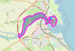
Walk directions
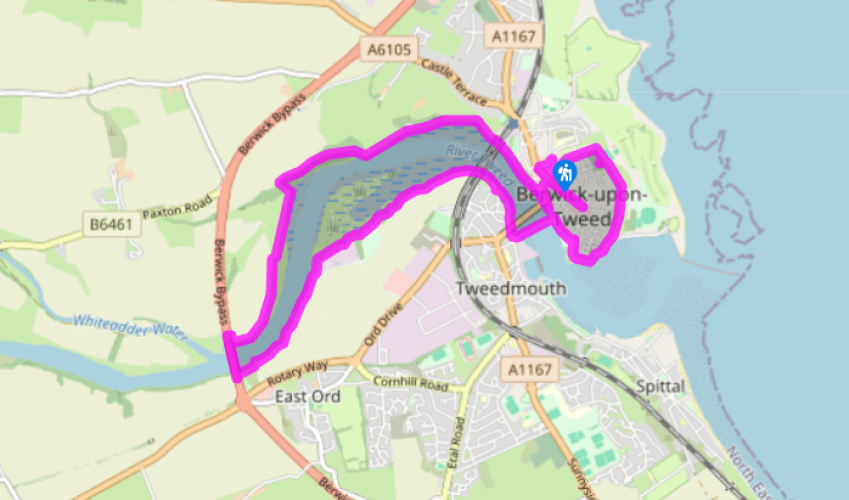
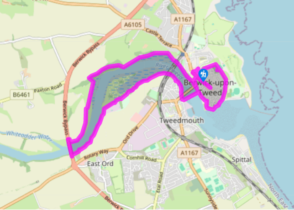
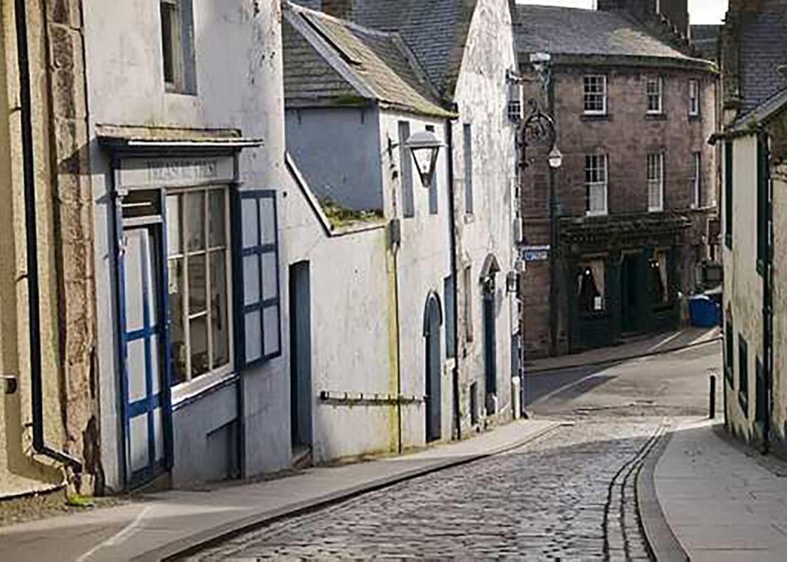
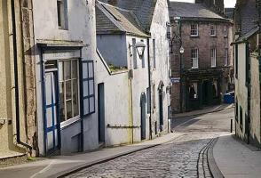
Leaving the car park, turn left beneath Scots Gate to first see the old town hall at the far end of Marygate. Return to Scots Gate, swinging left immediately before it along Bank Hill. Double back right onto the town walls by Meg’s Mount and walk past the Cumberland Bastion.
The next battery, Brass Bastion, lies at the northern corner of the town. Some 100yds (91m) beyond, a path descends inside the wall to meet The Parade by the corner of the parish church graveyard. Turn right past the barracks to the church – both are well worth visiting.
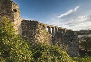
Return to the walls and continue around, passing Windmill Bastion and the site of the earlier Edward VI fort. Beyond King's Mount, the walls rise above the Tweed Estuary before turning upriver at Coxon's Tower, past elegant Georgian terraces and on above the old quay.
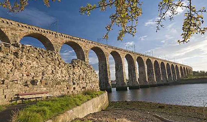
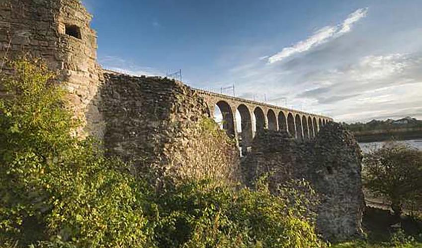
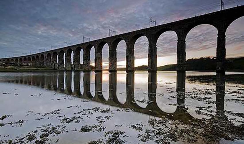
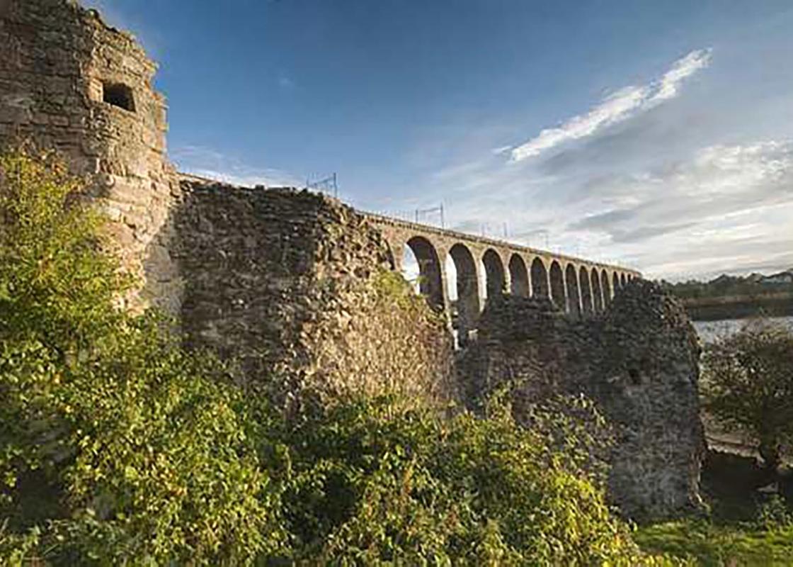
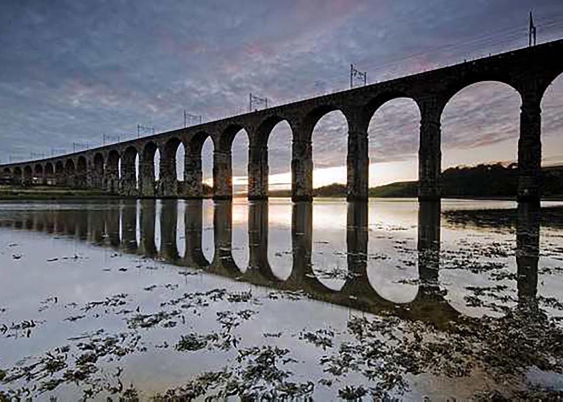
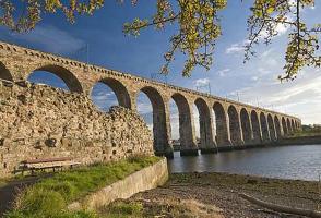
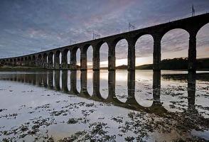
Leave the walls at Bridge End and cross the Old Bridge. Turn right past the war memorial, go beneath the modern Royal Tweed Bridge and remain by the river beyond, shortly passing below Stephenson's railway viaduct.
The way continues upstream along a sometimes muddy path. Where the bank widens to a rough meadow, keep left to pick up a good trail below a wooded bank. Beyond, continue through gates above flood marsh, eventually reaching a stile and gate. Carry on along a contained path beside trees that screen a water treatment plant, ultimately emerging onto a tarmac track. Turn right.
Almost immediately, bear off right at the edge of a field above the steep river bank. Continue beside the next field but, towards its far end, look for a stepped path descending to cross a stream. Climb to a stile and walk through a picnic area and car park to come out by a roundabout.
Keep right and follow the A1 across the Tweed. At the end of the crash barrier by a sign to Berwick drop right. Go over a couple of stiles and wind through scrub onto the edge of riverside pasture. Initially follow the left boundary, but later move right to rejoin the river. Eventually, after crossing a bridge over a side stream, bear right to a gate. Carry on through trees, rising to a path at the top of the bank.
Go right, eventually dropping from the wood by a cottage, where a riverside promenade leads back, through the castle wall to Berwick. Just beyond the Royal Tweed Bridge, double back left beneath it and continue beside the town walls to return to Scots Gate.
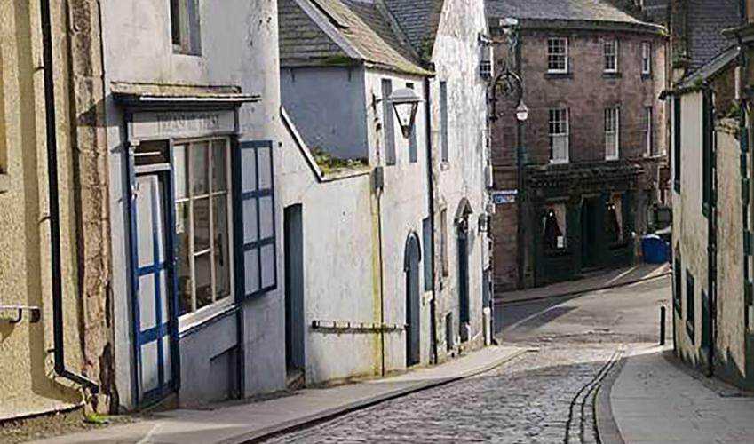
Overlooking the Tweed Estuary, Berwick is a true Border town which, despite standing on the northern bank, is actually in England. Yet in the 12th century it was a Scottish Royal Burgh and the country's most prosperous port, busy with the export of grain from a richly fertile hinterland. The town... first fell into English hands in 1174, but for the next 300 years was repeatedly attacked by one side or the other as each tried to wrest control. It changed ownership so many times that the long-suffering inhabitants must have wondered just whose side they were on. An English fortress When the political shuttlecock finally came to rest in 1482, Berwick found itself in England, although it retained the status of an independent state until 1836. However, the Scottish threat remained and, cut off from the surrounding countryside that had once made it rich, prosperity continued to be elusive until renewed threats of the 'Auld Alliance' prompted Elizabeth I to commission new fortifications in 1557. Wiping away much of the town's medieval walls, no longer effective against modern artillery, she spent £128,000 to enclose the town within thick ramparts and complex projecting bastions, from which defensive artillery could rake attacking forces. She probably wasted her money because the expected attack never came and the economic boost to the town was short-lived. A developing town It was not until the succession of James VI of Scotland to the English throne in 1603 that the town embarked on its road to recovery. The graceful bridge was built and the harbour developed and, by the middle of the 18th century, there was a regular packet service to London carrying both passengers and cargo. For the first time the salmon, for which the Tweed is still renowned, appeared in the capital's markets, kept fresh during the voyage by ice produced on the quayside. The boom continued into the 19th century, with a spate of elegant building catering for the civil, military, religious and domestic needs of the town. Perversely, the spanner that brought the economic wheel to a halt was the very thing that might have been envisaged to do just the opposite – the arrival of the railway. While it opened up many new areas and industries by providing cheap, fast and convenient transport for freight and people, it did no good at all for the coastal seafaring trade. The port, previously the key to the town's success, gradually dwindled and with it the trade it had once brought. Despite that, Berwick continues as a busy and attractive market town, with much of interest to see as you wander around its Elizabethan defences, unique for their completeness.
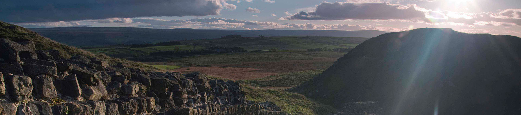
If it’s history you’re after, there’s heaps of it in Northumberland. On Hadrian’s Wall you can imagine scarlet-cloaked Roman legionaries keeping watch for painted Pictish warriors while cursing the English weather and dreaming of home.
"Discover the surprising history of a true border town."
Walk details
2hrs 15min
Difficulty:
Easy
Gradient:
Gentle
Distance:
6.5 miles (10.4kms)
Ascent:
400ft (122m)
Walk directions
Leaving the car park, turn left beneath Scots Gate to first see the old town hall at the far end of Marygate. Return to Scots Gate, swinging left immediately before it along Bank Hill. Double back right onto the town walls by Meg’s Mount and walk past the Cumberland Bastion.
1 of 8
The next battery, Brass Bastion, lies at the northern corner of the town. Some 100yds (91m) beyond, a path descends inside the wall to meet The Parade by the corner of the parish church graveyard. Turn right past the barracks to the church – both are well worth visiting.
2 of 8
Return to the walls and continue around, passing Windmill Bastion and the site of the earlier Edward VI fort. Beyond King's Mount, the walls rise above the Tweed Estuary before turning upriver at Coxon's Tower, past elegant Georgian terraces and on above the old quay.
3 of 8
Leave the walls at Bridge End and cross the Old Bridge. Turn right past the war memorial, go beneath the modern Royal Tweed Bridge and remain by the river beyond, shortly passing below Stephenson's railway viaduct.
4 of 8
The way continues upstream along a sometimes muddy path. Where the bank widens to a rough meadow, keep left to pick up a good trail below a wooded bank. Beyond, continue through gates above flood marsh, eventually reaching a stile and gate. Carry on along a contained path beside trees that screen a water treatment plant, ultimately emerging onto a tarmac track. Turn right.
5 of 8
Almost immediately, bear off right at the edge of a field above the steep river bank. Continue beside the next field but, towards its far end, look for a stepped path descending to cross a stream. Climb to a stile and walk through a picnic area and car park to come out by a roundabout.
6 of 8
Keep right and follow the A1 across the Tweed. At the end of the crash barrier by a sign to Berwick drop right. Go over a couple of stiles and wind through scrub onto the edge of riverside pasture. Initially follow the left boundary, but later move right to rejoin the river. Eventually, after crossing a bridge over a side stream, bear right to a gate. Carry on through trees, rising to a path at the top of the bank.
7 of 8
Go right, eventually dropping from the wood by a cottage, where a riverside promenade leads back, through the castle wall to Berwick. Just beyond the Royal Tweed Bridge, double back left beneath it and continue beside the town walls to return to Scots Gate.
Overlooking the Tweed Estuary, Berwick is a true Border town which, despite standing on the northern bank, is actually in England. Yet in the 12th century it was a Scottish Royal Burgh and the country's most prosperous port, busy with the export of grain from a richly fertile hinterland. The town... first fell into English hands in 1174, but for the next 300 years was repeatedly attacked by one side or the other as each tried to wrest control. It changed ownership so many times that the long-suffering inhabitants must have wondered just whose side they were on. An English fortress When the political shuttlecock finally came to rest in 1482, Berwick found itself in England, although it retained the status of an independent state until 1836. However, the Scottish threat remained and, cut off from the surrounding countryside that had once made it rich, prosperity continued to be elusive until renewed threats of the 'Auld Alliance' prompted Elizabeth I to commission new fortifications in 1557. Wiping away much of the town's medieval walls, no longer effective against modern artillery, she spent £128,000 to enclose the town within thick ramparts and complex projecting bastions, from which defensive artillery could rake attacking forces. She probably wasted her money because the expected attack never came and the economic boost to the town was short-lived. A developing town It was not until the succession of James VI of Scotland to the English throne in 1603 that the town embarked on its road to recovery. The graceful bridge was built and the harbour developed and, by the middle of the 18th century, there was a regular packet service to London carrying both passengers and cargo. For the first time the salmon, for which the Tweed is still renowned, appeared in the capital's markets, kept fresh during the voyage by ice produced on the quayside. The boom continued into the 19th century, with a spate of elegant building catering for the civil, military, religious and domestic needs of the town. Perversely, the spanner that brought the economic wheel to a halt was the very thing that might have been envisaged to do just the opposite – the arrival of the railway. While it opened up many new areas and industries by providing cheap, fast and convenient transport for freight and people, it did no good at all for the coastal seafaring trade. The port, previously the key to the town's success, gradually dwindled and with it the trade it had once brought. Despite that, Berwick continues as a busy and attractive market town, with much of interest to see as you wander around its Elizabethan defences, unique for their completeness.
If it’s history you’re after, there’s heaps of it in Northumberland. On Hadrian’s Wall you can imagine scarlet-cloaked Roman legionaries keeping watch for painted Pictish warriors while cursing the English weather and dreaming of home.