"A walk of big skies and far-reaching views to one of Dartmoor’s most impressive prehistoric sites."
Walk directions
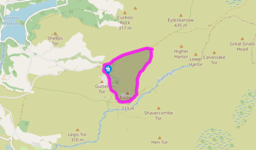
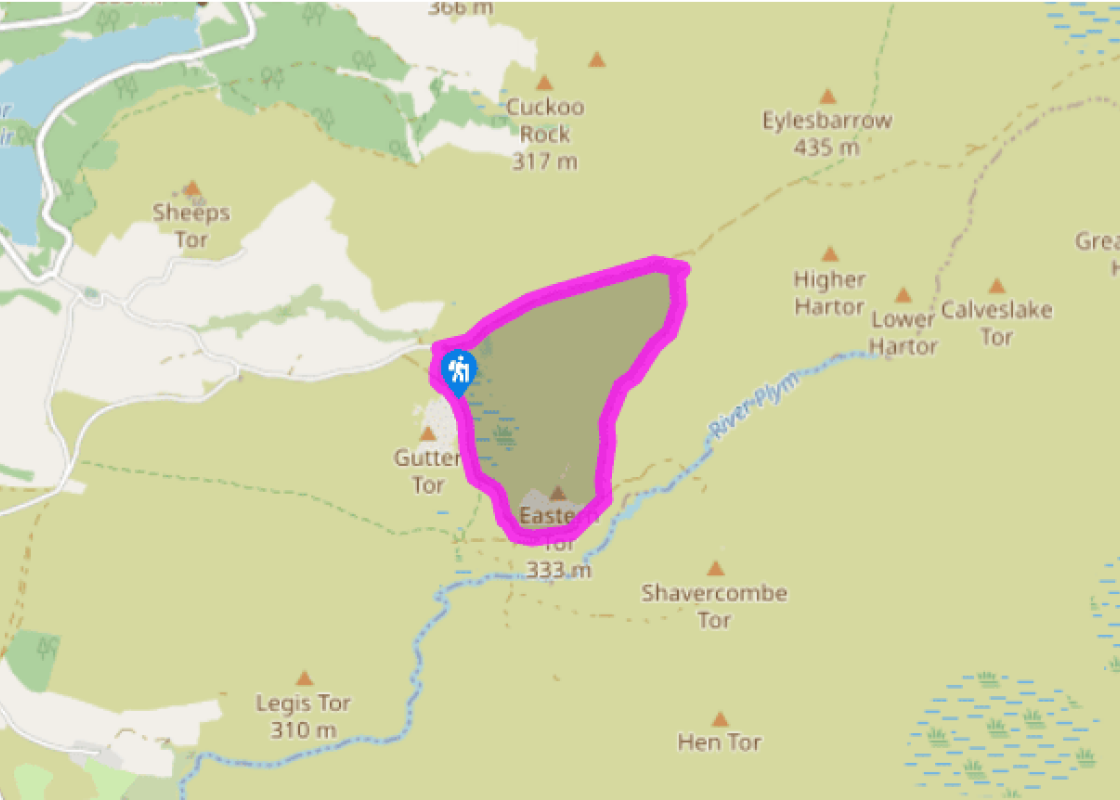
Start from a rough parking area just above the ford of the Sheepstor Brook, near the old Scout Hut at Gutter Tor. Cross the bridge over the stream and follow the rough track to the left of the Scout Hut into broad, sweeping moorland, ascending gently. Look left to see huge, blocky Sheeps Tor, and pointed Leather Tor to its right, both rising above Burrator Reservoir.
Follow the broad track – rocky underfoot – which eventually leads to Eylesbarrow Tin Mine. Before reaching the mine the track levels, with views to Shavercombe and Legis Tors on the south side of the Plym Valley.
Just past a pathside boundary stone of 1917, bear right on a track that descends gently to meet a crossroads of rough paths, with the rounded corner of a dilapidated wall opposite.
Turn right and walk along the edge of Drizzlecombe, with boggy ground below left. Soon pass the remains of old buildings, with sweeping views ahead across Ditsworthy Warren. Where an indistinct track bears left across the combe, keep straight on.
Soon cross a leat. Continue on a broad, grassy path that runs ahead through bracken, with Drizzlecombe below left. The route runs to the left of Eastern Tor ahead. Look left to see the Drizzlecombe Longstone, with another standing stone to its right, and another ahead and to the right of the path. Cross a narrow path and keep ahead, soon bearing slightly left with the grassy path towards the River Plym, passing a recumbent gatepost on the way.
Meet a cart track that runs left towards the stone rows, and turn right. Follow the rutted track parallel to the River Plym. Scrubby conifers and dilapidated walls appear ahead, marking the site of Ditsworthy Warren House, overlooking the Plym Valley.
Pass the house, and cross a small stream to meet a broad and muddy track. Bear right along it; craggy Gutter Tor soon comes into view ahead, and later the conifers around the Scout Hut, right.
Pass round a gate. A few paces later, bear right across rough grassland to meet the approach lane to the parking area, and turn right to return to your car.
Within minutes of starting this walk you’ll be rewarded with expansive views of some of the widest landscapes Dartmoor has to offer. The focus of the route is Drizzlecombe, which is also known as ‘Thrushelcombe’ – the old moorland name for a thrush was drishel. It's a broad sweep of sloping... moorland above the banks of the infant River Plym, renowned for its wealth of prehistoric monuments. The moor’s tallest standing stone or menhir is the Drizzlecombe longstone, 15ft (4.5m) high, and passed at Point 5. This triangular route, largely along rough tracks, is easy to follow, despite passing through a very remote landscape. A long history The Drizzlecombe Valley is an important archaeological site for its wealth of Bronze Age monuments, including the impressive Giant’s Cairn. The extensive array includes three stone rows, standing stones, cists, cairns, pounds and hut circles, and evidence of a settlement 4,000 years ago at Whittenknowles Rocks. Ditsworthy Warren Remotely situated Ditsworthy Warren House, reached at the end of Point 6, dates from the 16th century. Once known as Ware’s Warren, after the family who lived there, Ditsworthy Warren was at one time the largest commercial rabbit warren on Dartmoor, covering almost 1,100 acres (445ha) and rearing rabbits for food and skins – the practice was banned in the 1950s. More recently the house was used as the location for the Narracott family’s home in the 2011 movie War Horse, much of which was filmed in the surrounding area.
Devon sums up all that is best about the British landscape, with its magnificent coastlines, two historic cities, the world-famous Dartmoor National Park and south Devon’s glorious English Riviera. A fashionable and much-loved holiday destination, hiking and cycling in the National Parks is extremely popular among visitors, with a great choice of off-road routes.
"A walk of big skies and far-reaching views to one of Dartmoor’s most impressive prehistoric sites."
Walk details
1hr 30min
Difficulty:
Medium
Gradient:
Gentle
Distance:
3 miles (4.8kms)
Ascent:
197ft (60m)
Walk directions
Start from a rough parking area just above the ford of the Sheepstor Brook, near the old Scout Hut at Gutter Tor. Cross the bridge over the stream and follow the rough track to the left of the Scout Hut into broad, sweeping moorland, ascending gently. Look left to see huge, blocky Sheeps Tor, and pointed Leather Tor to its right, both rising above Burrator Reservoir.
1 of 8
Follow the broad track – rocky underfoot – which eventually leads to Eylesbarrow Tin Mine. Before reaching the mine the track levels, with views to Shavercombe and Legis Tors on the south side of the Plym Valley.
2 of 8
Just past a pathside boundary stone of 1917, bear right on a track that descends gently to meet a crossroads of rough paths, with the rounded corner of a dilapidated wall opposite.
3 of 8
Turn right and walk along the edge of Drizzlecombe, with boggy ground below left. Soon pass the remains of old buildings, with sweeping views ahead across Ditsworthy Warren. Where an indistinct track bears left across the combe, keep straight on.
4 of 8
Soon cross a leat. Continue on a broad, grassy path that runs ahead through bracken, with Drizzlecombe below left. The route runs to the left of Eastern Tor ahead. Look left to see the Drizzlecombe Longstone, with another standing stone to its right, and another ahead and to the right of the path. Cross a narrow path and keep ahead, soon bearing slightly left with the grassy path towards the River Plym, passing a recumbent gatepost on the way.
5 of 8
Meet a cart track that runs left towards the stone rows, and turn right. Follow the rutted track parallel to the River Plym. Scrubby conifers and dilapidated walls appear ahead, marking the site of Ditsworthy Warren House, overlooking the Plym Valley.
6 of 8
Pass the house, and cross a small stream to meet a broad and muddy track. Bear right along it; craggy Gutter Tor soon comes into view ahead, and later the conifers around the Scout Hut, right.
7 of 8
Pass round a gate. A few paces later, bear right across rough grassland to meet the approach lane to the parking area, and turn right to return to your car.
Within minutes of starting this walk you’ll be rewarded with expansive views of some of the widest landscapes Dartmoor has to offer. The focus of the route is Drizzlecombe, which is also known as ‘Thrushelcombe’ – the old moorland name for a thrush was drishel. It's a broad sweep of sloping... moorland above the banks of the infant River Plym, renowned for its wealth of prehistoric monuments. The moor’s tallest standing stone or menhir is the Drizzlecombe longstone, 15ft (4.5m) high, and passed at Point 5. This triangular route, largely along rough tracks, is easy to follow, despite passing through a very remote landscape. A long history The Drizzlecombe Valley is an important archaeological site for its wealth of Bronze Age monuments, including the impressive Giant’s Cairn. The extensive array includes three stone rows, standing stones, cists, cairns, pounds and hut circles, and evidence of a settlement 4,000 years ago at Whittenknowles Rocks. Ditsworthy Warren Remotely situated Ditsworthy Warren House, reached at the end of Point 6, dates from the 16th century. Once known as Ware’s Warren, after the family who lived there, Ditsworthy Warren was at one time the largest commercial rabbit warren on Dartmoor, covering almost 1,100 acres (445ha) and rearing rabbits for food and skins – the practice was banned in the 1950s. More recently the house was used as the location for the Narracott family’s home in the 2011 movie War Horse, much of which was filmed in the surrounding area.
Devon sums up all that is best about the British landscape, with its magnificent coastlines, two historic cities, the world-famous Dartmoor National Park and south Devon’s glorious English Riviera. A fashionable and much-loved holiday destination, hiking and cycling in the National Parks is extremely popular among visitors, with a great choice of off-road routes.